Location
Latitude: |
46-48-01.7050N (46.800474) |
Longitude: |
102-48-15.9670W (-102.804435) |
Elevation: |
2592.1 feet MSL (790 m MSL) |
Magnetic Variation: |
7 E (as of April 2024 from WMM2020 model) |
Time Zone: |
UTC -7.0 (Standard Time) UTC -6.0 (Daylight Savings Time) |
From City: |
05 N.M. S of Dickinson, North Dakota |
Found On: |
Billings Chart |
FAA Region: |
AGL |
Contacts
Manager: |
Publicly owned: |
| KELLY BRAUN 11120 42ND ST SW DICKINSON, ND 58601-9282 701-483-1062 |
DICKINSON ARPT AUTHORITY 11120 42ND ST SW DICKINSON, ND 58601-9282 701-483-1062 |
Operations
Airport Status: |
Operational |
Facility Use: |
Public |
Type: |
Airport |
Activation Date: |
10/1938 |
Control tower: |
No |
Attendance (Months/Days/Hours): |
Months/Days/Hours ALL/ALL/0700-1600 |
Boundary ARTCC: |
ZMP (Minneapolis) |
Responsible ARTCC: |
ZMP (Minneapolis) |
Lighting Schedule: |
SEE RMK |
Segmented Circle Indicator: |
Yes |
Traffic Pattern Altitude (MSL): |
3592 feet (1095 m) |
NOTAMs Facility: |
DIK |
NOTAM-D Service: |
Yes |
International Airport of Entry: |
No |
Customs Landing Rights: |
No |
Military Landing Rights: |
Yes |
Civil/Military Joint Use: |
No |
Aircraft Rescue and Firefighting: |
Class I ARFF Index: A Air Carrier Service: Scheduled Certification Date: 07/2006 |
Based Aircraft
| Single Engine: | 32 |
| Multi Engine: | 3 |
Annual Operations (as of 12/31/2022)
| Total Operations: | 4490 | |
| Commercial: | 1452 | 32.3% |
| Air Taxi: | 1000 | 22.3% |
| GA Local: | 1202 | 26.8% |
| GA Itinerant: | 824 | 18.4% |
| Military Aircraft: | 12 | 0.3% |
Communications
| CTAF: | 123.000 |
| Unicom: | 123.000 |
| ASOS: | 118.375 (701-227-0280) |
- APCH/DEP SVC PRVDD BY MINNEAPOLIS ARTCC ON FREQS 124.25/236.825 (DICKINSON RCAG).
- COMMUNICATIONS PRVDD BY GRAND FORKS RADIO ON FREQ 122.2 (DICKINSON RCO).
Fixed Based Operators (FBOs) & Fuel
(Click on a business for detail)
Please help us keep this information up to date. This is a FREE SERVICE just like everything else on Airport Guide! If you see that a business needs to be added, modified, or deleted please fill out our Update Form.
To add, modify, or delete a business click here.
Please help us keep this information up to date. This is a FREE SERVICE just like everything else on Airport Guide! If you see that a business needs to be added, modified, or deleted please fill out our Update Form.
Area Code: 701 |
| Business Name | Frequency | Phone | Fuel Grade |
|---|---|---|---|
| Dickinson Air Service
Update FBO info |
Unicom 123.0 | 225-4221 | 100LL, Jet A |
Flight Service Stations
| Primary | Alternate | |
| FSS on Field: | ||
| FSS Name (ID): | Grand Forks(GFK) | |
| Frequency: | ||
| Toll Free Phone: | 1-800-WX-BRIEF |
Instrument Procedures / Charts
FAA Terminal Procedures valid from 0901Z 03/21/24 to 0901Z 04/18/24.
There are various types of charts available for an airport. They are listed in the Page Type column. Here is a legend for those types:
APD - Airport Diagram
DP - Departure Procedure Charts
HOT - Hot Spots
IAP - Instrument Approach Procedure Charts
MIN - Minimums
STAR - Standard Terminal Arrival Charts
| Page Type | Page Name | Volume | Action Since Last Cycle |
|---|---|---|---|
| APD | AIRPORT DIAGRAM | NC-1 | |
| IAP | ILS OR LOC RWY 32 | NC-1 | |
| IAP | RNAV (GPS) RWY 07 | NC-1 | |
| IAP | RNAV (GPS) RWY 14 | NC-1 | |
| IAP | RNAV (GPS) RWY 25 | NC-1 | |
| IAP | RNAV (GPS) RWY 32 | NC-1 | |
| IAP | VOR-A | NC-1 | |
| MIN | ALTERNATE MINIMUMS | NC-1 | |
| MIN | TAKEOFF MINIMUMS | NC-1 |
Terminal Procedures are only available for airports in several countries with more being added all the time. If you are looking for a specific country's charts, please send an email to support(at)airportguide.com stating the country name. This will be used to prioritize the implementation.
Navigation Aids (Navaids) near DIK
| Dist (NM) | ID | Morse Code | Name | Type | Freq | True Hdg | Mag Hdg |
|---|---|---|---|---|---|---|---|
| 3.8 | DIK | _ . . . . _ . _ | Dickinson | VORTAC | 112.90 | 19 | 12 |
| 7.7 | DI | _ . . . . | Noson | NDB | 353 | 150 | 143 |
| 45.0 | BOD | _ . . . _ _ _ _ . . | Bowman | NDB | 374 | 215 | 208 |
| 60.3 | LEM | . _ . . . _ _ | Lemmon | VOR | 111.40 | 150 | 143 |
| 65.7 | BKU | _ . . . _ . _ . . _ | Timber | NDB | 344 | 246 | 239 |
| 78.3 | SDY | . . . _ . . _ . _ _ | Sidney | NDB | 359 | 314 | 307 |
| 79.6 | BUA | _ . . . . . _ . _ | Buffalo | DME | 109.4 | 200 | 193 |
| 84.1 | SF | . . . . . _ . | Yuson | NDB | 275 | 340 | 333 |
| 84.3 | GDV | _ _ . _ . . . . . _ | Glendive | NDB | 410 | 284 | 276 |
| 84.3 | GDV | _ _ . _ . . . . . _ | Glendive | DME | 114.35 | 284 | 276 |
| 86.7 | ISN | . . . . . _ . | Williston | NDB | 275 | 338 | 331 |
| 87.9 | BIS | _ . . . . . . . . | Bismarck | VOR-DME | 115.65 | 90 | 84 |
| 88.9 | BI | _ . . . . . | Jadan | NDB | 230 | 93 | 87 |
| 95.2 | ISN | . . . . . _ . | Williston | VOR-DME | 116.30 | 336 | 329 |
Nearby Airports with Fuel
| Dist (NM) | Name (Airport IDs) | True Hdg | Mag Hdg | Fuel Grade |
|---|---|---|---|---|
| 0.0 | Dickinson/Theodore Roosevelt Regional Airport (DIK KDIK DIK) |
0 | 353 | 100LL, Jet A |
| 47.5 | Hettinger/Jb Lindquist Regional Airport (KHEI HEI) |
172 | 165 | 100LL, Jet A |
| 58.0 | Mercer County Regional Airport (KHZE HZE) |
59 | 53 | 100LL, Jet A |
| 65.9 | Baker Municipal Airport (KBHK BHK) |
246 | 238 | 100LL, Jet A+ |
| 73.2 | Parshall-Hankins Airport (Y74) |
21 | 14 | 100LL |
| 78.2 | Bison Municipal Airport (6V5) |
169 | 162 | 100LL |
| 78.4 | Sidney-Richland Regional Airport (SDY KSDY SDY) |
314 | 306 | 100LL, Jet A |
| 78.5 | Mandan Regional/Lawler Field Airport (Y19) |
90 | 84 | 100LL, Jet A |
| 79.8 | Washburn Municipal Airport (5C8) |
64 | 58 | 100LL |
| 84.5 | Dawson Community Airport (GDV KGDV GDV) |
284 | 276 | 100LL, Jet A+ |
| 84.6 | Bismarck Municipal Airport (BIS KBIS BIS) |
90 | 84 | 100LL, Jet A |
| 91.5 | Stanley Municipal Airport (08D) |
9 | 2 | 100LL, Jet A+, MOGAS |
| 94.9 | Tioga Municipal Airport (VEX D60) |
357 | 350 | 100LL, Jet A |
Notices to Airmen (NOTAMS)
Remarks
| A110-10 | HAYING OPNS ADJ TO ALL SFCS JUN - SEP. |
| A110-11 | CROP DUSTING OPNS INVOF ARPT. |
| A110-12 | PAEW ON MOVEMENT AREAS DURG WINTER (OCT-APR). |
| A110-14 | AIRFIELD SFC CONDS UNMON BTN 2300-0430. |
| A110-17 | FOR CD IF UNA TO CTC ON FSS FREQ, CTC MINNEAPOLIS ARTCC AT 651-463-5588. |
| A110-9 | CONC APRON FOR HEAVY ACFT PARKING. |
| A17 | FOR SVC AFT HRS CALL (701) 264-9966. |
| A30-07/25 | RWY 7/25 NOT AVBL FOR SKEDD ACR OPNS WITH MORE THAN 9 PSGR SEATS OR UNSKED ACR AT LEAST 31 PSGR SEATS. |
| A81-APT | ACTVT MALSR RWY 32; REIL RWY 14, 07 & 25; PAPI RWY 07, 25, 14 & 32; HIRL RWY 14/32 - CTAF. MIRL RWY 07/25 PRESET ON LOW INTST DUSK-2200; TO INCR INTST AFT 2200 - CTAF. |
| E147 | TPA SNGL ENG 1010 FT AGL; MULT ENG 1510 FT AGL. |
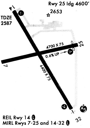
Runways
Runway Summary
| Runways: | 07/25 14/32 |
| Longest Runway: | 14/32 is 7301 ft (2225 m) long |
| Runways with an Instrument Approach: | 32 |
DIK Airport Runway Details
| Runway 07/25 | 4700 ft x 75 ft (1433 m x 23 m) | |
| Runway Length Source: | 3RD PARTY SURVEY as of 05/30/2020 | |
| Surface: | Asphalt - Good condition - Saw-cut or plastic grooved | |
| Runway Pavement Class: | 5 /F/D/W/T | |
| Runway Edge Lights: | Medium Intensity | |
Runway Weight Bearing Capacity (in thousands of pounds) |
||
| Single Wheel Landing Gear: | 16.0 | |
| Dual Wheel Landing Gear: | 20.0 | |
Runway 07 |
Runway 25 |
|
Elevation: |
2571.7 | 2592.1 |
Latitude: |
46-47-46.4864N | 46-47-54.7544N |
Longitude: |
102-48-41.9961W | 102-47-35.5371W |
|
Runway True Alignment: |
080 | 260 |
Glide Path Angle: |
3.0 degrees | 3.0 degrees |
Runway Markings Type: |
Nonprecision Instrument | Nonprecision Instrument |
Runway Markings Condition: |
Fair | Good |
Object at End: |
ROAD | |
Object Height: |
28 | |
Distance from End: |
790 | |
Object Centerline Offset: |
300 ft. left of centerline | |
Visual Glide Slope Indicators: |
2-Light PAPI On Left Side Of Runway | 2-Light PAPI On Left Side Of Runway |
REIL: |
Yes | Yes |
Threshold Crossing Height: |
28 | 28 |
Declared Distances |
||
Take Off Run Avbl. (TORA): |
4700 | 4700 |
Take Off Distance Avbl. (TODA): |
4700 | 4700 |
Actual Stop Dist. Avbl. (ASDA): |
4700 | 4700 |
Landing Dist. Avbl. (LDA): |
4700 | 4700 |
| Runway 14/32 | 7301 ft x 150 ft (2225 m x 46 m) | |
| Runway Length Source: | 3RD PARTY SURVEY as of 05/30/2020 | |
| Surface: | Asphalt - Good condition - Saw-cut or plastic grooved | |
| Runway Pavement Class: | 25 /R/B/W/T | |
| Runway Edge Lights: | High Intensity | |
Runway Weight Bearing Capacity (in thousands of pounds) |
||
| Single Wheel Landing Gear: | 60.0 | |
| Dual Wheel Landing Gear: | 90.0 | |
| Dual Tandem Wheel Landing Gear: | 90.0 | |
Runway 14 |
Runway 32 |
|
Elevation: |
2581.8 | 2581.5 |
Latitude: |
46-48-40.1637N | 46-47-37.5138N |
Longitude: |
102-48-46.5306W | 102-47-54.6822W |
|
Runway True Alignment: |
150 | 330 |
ILS Type: |
ILS/DME | |
Glide Path Angle: |
3.0 degrees | 3.0 degrees |
Runway Markings Type: |
Precision Instrument | Precision Instrument |
Runway Markings Condition: |
Good | Good |
Object at End: |
POLE | ROAD |
Object Height: |
65 | 37 |
Distance from End: |
2686 | 2344 |
Object Centerline Offset: |
300 ft. left of centerline | |
Visual Glide Slope Indicators: |
4-Light PAPI On Left Side Of Runway | 4-Light PAPI On Left Side Of Runway |
Approach Light System: |
1,400 Foot Medium Intensity Approach Lighting System With Runway Alignment Indicator Lights | |
REIL: |
Yes | No |
Threshold Crossing Height: |
50 | 50 |
Declared Distances |
||
Take Off Run Avbl. (TORA): |
7301 | 7301 |
Take Off Distance Avbl. (TODA): |
7301 | 7301 |
Actual Stop Dist. Avbl. (ASDA): |
7301 | 7301 |
Landing Dist. Avbl. (LDA): |
7301 | 7301 |
Services
Airframe Repair: |
Major |
Powerplant Repair: |
Major |
Bulk Oxygen: |
None |
Fuel Available: |
100LL, Jet A |
Landing Fees: |
No |
Parking: |
Hangars and tiedowns available |
Maps & Diagrams
DIK Sectional
Flight Planning
at skyvector.com
at skyvector.com