Location
Latitude: |
41-09-20.3000N (41.155639) |
Longitude: |
104-48-37.7000W (-104.810472) |
Elevation: |
6159.9 feet MSL (1878 m MSL) |
Magnetic Variation: |
7.7 E (as of April 2024 from WMM2020 model) |
Time Zone: |
UTC -7.0 (Standard Time) UTC -6.0 (Daylight Savings Time) |
From City: |
01 N.M. N of Cheyenne, Wyoming |
Found On: |
Cheyenne Chart |
FAA Region: |
ANM |
Contacts
Manager: |
Publicly owned: |
| TIM BRADSHAW 1401 AIRPORT PARKWAY CHEYENNE, WY 82001 307-426-4151 |
CHEYENNE ARPT BOARD PO BOX 2210 CHEYENNE, WY 82003 307-634-7071 |
Operations
Airport Status: |
Operational |
Facility Use: |
Public |
Type: |
Airport |
Activation Date: |
10/1937 |
Control tower: |
Yes |
Attendance (Months/Days/Hours): |
Months/Days/Hours ALL/ALL/0600-2200 |
Boundary ARTCC: |
ZDV (Denver) |
Responsible ARTCC: |
ZDV (Denver) |
Lighting Schedule: |
SEE RMK |
Segmented Circle Indicator: |
Yes |
Traffic Pattern Altitude (MSL): |
7160 feet (2182 m) |
NOTAMs Facility: |
CYS |
NOTAM-D Service: |
Yes |
Military Landing Rights: |
Yes |
Aircraft Rescue and Firefighting: |
Class I ARFF Index: A Air Carrier Service: Scheduled Certification Date: 05/1973 |
Based Aircraft
| Single Engine: | 30 |
| Multi Engine: | 7 |
| Jet Engine: | 2 |
| GA Helicopters: | 2 |
| Military Aircraft: | 8 |
Annual Operations (as of 12/31/2020)
| Total Operations: | 33250 | |
| Commercial: | 39 | 0.1% |
| Air Taxi: | 1083 | 3.3% |
| GA Local: | 17715 | 53.3% |
| GA Itinerant: | 3126 | 9.4% |
| Military Aircraft: | 11287 | 33.9% |
Communications
| CTAF: | 118.700 |
| Unicom: | 122.950 |
| Tower: | CHEYENNE 118.7 257.8 Hrs: 0600-2200 |
| Ground: | 121.9 254.275 |
| Approach: | CHEYENE 124.55 263.075 Hrs: 0600-2200 DENVER ARTCC Hrs: 2200-0600 |
| Departure: | CHEYENE 124.55 263.075 Hrs: 0600-2200 DENVER ARTCC Hrs: 2200-0600 |
| ATIS: | 134.425 278.3 Hrs: 24 |
| ASOS: | (307-632-7680) |
| ANG COMD POST: | 257.1 |
| EMERG: | 121.5 |
| ANG OPS: | 257.1 |
| ARNG OPS: | 134.1 ;CALL STEAMBOAT |
| ARNG OPS: | 242.4 ;CALL STEAMBOAT |
| EMERG: | 243.0 |
- APCH/DEP CTL SVC PRVDD BY DENVER ARTCC (ZDV) ON FREQS 125.9/284.7 (CHEYENNE RCAG) WHEN CHEYENNE APCH CTL (CYS) CLSD.
Fixed Based Operators (FBOs) & Fuel
(Click on a business for detail)
Please help us keep this information up to date. This is a FREE SERVICE just like everything else on Airport Guide! If you see that a business needs to be added, modified, or deleted please fill out our Update Form.
To add, modify, or delete a business click here.
Please help us keep this information up to date. This is a FREE SERVICE just like everything else on Airport Guide! If you see that a business needs to be added, modified, or deleted please fill out our Update Form.
Area Code: 307 |
| Business Name | Frequency | Phone | Fuel Grade |
|---|---|---|---|
| Cheyenne Airmotive
Update FBO info |
778-2000 | ||
| Sky Harbor Air Services
Update FBO info |
Unicom 122.95 | 634-4417 | 100LL, Jet A |
Flight Service Stations
| Primary | Alternate | |
| FSS on Field: | N | |
| FSS Name (ID): | Casper(CPR) | |
| Frequency: | ||
| Toll Free Phone: | 1-800-WX-BRIEF |
Instrument Procedures / Charts
FAA Terminal Procedures valid from 0901Z 03/21/24 to 0901Z 04/18/24.
There are various types of charts available for an airport. They are listed in the Page Type column. Here is a legend for those types:
APD - Airport Diagram
DP - Departure Procedure Charts
HOT - Hot Spots
IAP - Instrument Approach Procedure Charts
MIN - Minimums
STAR - Standard Terminal Arrival Charts
| Page Type | Page Name | Volume | Action Since Last Cycle |
|---|---|---|---|
| APD | AIRPORT DIAGRAM | NW-1 | |
| HOT | HOT SPOT | NW-1 | |
| IAP | ILS OR LOC RWY 27 | NW-1 | |
| IAP | RNAV (GPS) RWY 09 | NW-1 | |
| IAP | RNAV (GPS) RWY 13 | NW-1 | |
| IAP | RNAV (GPS) RWY 27 | NW-1 | |
| IAP | RNAV (GPS) RWY 31 | NW-1 | |
| IAP | VOR OR TACAN-A | NW-1 | |
| MIN | ALTERNATE MINIMUMS | NW-1 | |
| MIN | RADAR MINIMUMS | NW-1 | |
| MIN | TAKEOFF MINIMUMS | NW-1 |
Terminal Procedures are only available for airports in several countries with more being added all the time. If you are looking for a specific country's charts, please send an email to support(at)airportguide.com stating the country name. This will be used to prioritize the implementation.
Navigation Aids (Navaids) near CYS
| Dist (NM) | ID | Morse Code | Name | Type | Freq | True Hdg | Mag Hdg |
|---|---|---|---|---|---|---|---|
| 3.7 | CYS | _ . _ . _ . _ _ . . . | Cheyenne | VORTAC | 113.10 | 27 | 19 |
| 40.8 | GLL | _ _ . . _ . . . _ . . | Gill | VOR-DME | 114.20 | 163 | 155 |
| 42.5 | LAR | . _ . . . _ . _ . | Laramie | VOR-DME | 117.60 | 285 | 277 |
| 48.1 | FN | . . _ . _ . | Colln | NDB | 400 | 188 | 180 |
| 50.0 | DC | _ . . _ . _ . | Buffs | NDB | 348 | 170 | 162 |
| 62.1 | TOR | _ _ _ _ . _ . | Torrington | NDB | 293 | 28 | 20 |
| 65.2 | GYZ | _ _ . _ . _ _ _ _ . . | Camp Guernsey | NDB | 280 | 3 | 355 |
| 67.8 | MBW | _ _ _ . . . . _ _ | Medicine Bow | VOR-DME | 116.85 | 308 | 300 |
| 70.6 | BF | _ . . . . . _ . | Creve | NDB | 263 | 56 | 49 |
| 74.3 | BFF | _ . . . . . _ . . . _ . | Scottsbluff | VORTAC | 112.60 | 52 | 45 |
| 76.0 | BJC | _ . . . . _ _ _ _ . _ . | Jeffco | VOR-DME | 115.40 | 191 | 183 |
| 76.1 | DVV | _ . . . . . _ . . . _ | Mile High | VORTAC | 114.70 | 173 | 165 |
| 77.4 | DEN | _ . . . _ . | Denver | VOT | 110.00 | 174 | 166 |
| 80.9 | DEN | _ . . . _ . | Denver | VOR-DME | 117.90 | 175 | 167 |
| 80.9 | BAJ | _ . . . . _ . _ _ _ | Batten | NDB | 392 | 117 | 110 |
| 82.7 | SNY | . . . _ . _ . _ _ | Sidney | VOR-DME | 115.90 | 91 | 84 |
| 83.6 | FT | . . _ . _ | Skipi | NDB | 321 | 168 | 160 |
| 86.9 | BKF | _ . . . _ . _ . . _ . | Buckley | TACAN | 109.60 | 178 | 170 |
| 88.4 | FQF | . . _ . _ _ . _ . . _ . | Falcon | VORTAC | 116.30 | 174 | 166 |
| 92.8 | SAA | . . . . _ . _ | Saratoga | NDB | 266 | 281 | 273 |
Nearby Airports with Fuel
Notices to Airmen (NOTAMS)
Remarks
| A110-10 | PILOTS SHOULD AVOID F.E. WARREN AFHP AT ALL TIMES. |
| A110-11 | MILITARY: RSTD: ANG PPR REQ TO PRK ON MIL RAMP. |
| A110-12 | MILITARY: ANG: LMTD DEICE SVC AVBL TO MIL ACFT WITH ANG PPR. PPR DSN 388-6355/6879, C307-772-6355/6879. |
| A110-13 | HEAVY COPTER TFC 2 NM SW OF ARPT, SFC TO 1000 FT DUR DALGT, WEEKDAYS. |
| A110-14 | RSTD: TWY C CLSD NORTH OF TWY F, TWY D, AND G CLSD INDEFLY. |
| A110-15 | CAUTION: TWY B1, C AND E HOLD SHORT LINES FOR ALL RWYS |
| A110-16 | BASH PHASE II, INCR BIRD HAZ MAY-SEP. |
| A110-17 | MILITARY: INFO: SEE FLIP AP/1 SUPPLEMENTARY ARPT INFO. |
| A110-18 | MILITARY: ANG: BASE OPS NML OPR 1300-2230Z++ MON-THU, LTD FRI, CLSD SAT, SUN AND HOL. |
| A110-19 | MILITARY: ANG: ALL TRAN ACFT CTC ANG COWBOY OPS 15 MIN PRIOR TO LDG. |
| A110-20 | MILITARY: ANG: COMD POST DSN388-6470, C307-772-6470 NML OPR 1300-2230Z++ MON-THU, LTD FRI, CLSD SAT, SUN, AND HOL. |
| A110-21 | MILITARY: ANG: SPOT 9 CLSD ON PRK RAMP UFN. |
| A110-22 | MILITARY: SVC: FUEL: A++(MIL) AVBL AT ANG |
| A110-23 | MILITARY: ANG: NO TWY EDGE LGT ON TWY C & TWY F. NSTD WHITE AGE BOX MKGS ON APN. NST FIRE LANE MRKS ON APN. |
| A110-24 | MILITARY: ANG: CSTMS/AG - SVC UNAVBL. |
| A110-25 | RWY: RWY 09/27 & RWY 13/31 HAVE PAINTED ASSAULT LNDG ZONE MKGS. |
| A110-26 | FOR CD CTC CHEYENNE APCH AT 307-772-6032, WHEN APCH CLSD CTC DENVER ARTCC AT 303-651-4257. |
| A110-27 | EMERG AFT TWR CLSD CTC ARFF 307-772-6338. |
| A110-4 | RCR AVBL ON REQ FM ATCT 0600-2200 30 MIN PRIOR NOTICE REQUIRED. |
| A110-8 | BIRD ACTIVITY INVOF ARPT. |
| A24 | TIEDOWN FEE. |
| A26 | PPR FOR UNSKED ACR OPNS WHEN ATCT CLSD CALL AMGR 307-638-3872. |
| A57-09 | APCH RATIO 17:1 FM DSPLCD THR. |
| A58-13 | +9 FT FENCE, 199 FT FM RWY END, 400 FT RGT. |
| A70-FUEL-10 | 0LL AFTER HOURS FUEL CALL 307-634-7079. |
| A81-APT | ACTVT MALSR RWY 27; REIL RWY 09, 13, 31; PAPI RWY 09, 27, 13, 31; HIRL RWY 09/27; MIRL RWY 13/31 - CTAF |
Runways
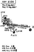
Runway Summary
| Runways: | 09/27 13/31 |
| Longest Runway: | 09/27 is 9270 ft (2825 m) long |
| Runways with an Instrument Approach: | 27 |
CYS Airport Runway Details
| Runway 09/27 | 9270 ft x 150 ft (2825 m x 46 m) | |
| Runway Length Source: | 3RD PARTY SURVEY as of 05/24/2013 | |
| Surface: | Concrete - Fair condition - Saw-cut or plastic grooved | |
| Runway Edge Lights: | High Intensity | |
Runway Weight Bearing Capacity (in thousands of pounds) |
||
| Single Wheel Landing Gear: | 75.0 | |
| Dual Wheel Landing Gear: | 140.0 | |
| Dual Tandem Wheel Landing Gear: | 150.0 | |
| Dual Dual Tandem Wheel Landing Gear: | 250.0 | |
Runway 09 |
Runway 27 |
|
Elevation: |
6145.8 | 6094.4 |
Latitude: |
41-09-24.3480N | 41-09-15.8885N |
Longitude: |
104-49-16.1482W | 104-47-15.5205W |
|
Runway True Alignment: |
095 | 275 |
ILS Type: |
ILS/DME | |
Glide Path Angle: |
3.0 degrees | 3.0 degrees |
Traffic Pattern: |
Left | Left |
Runway Markings Type: |
Precision Instrument | Precision Instrument |
Runway Markings Condition: |
Good | Good |
Visual Glide Slope Indicators: |
4-Light PAPI On Left Side Of Runway | 4-Light PAPI On Left Side Of Runway |
Runway Visual Range (RVR): |
Rollout | Touchdown |
Approach Light System: |
1,400 Foot Medium Intensity Approach Lighting System With Runway Alignment Indicator Lights | |
REIL: |
Yes | |
Threshold Crossing Height: |
50 | 55 |
Threshold Elevation: |
6143.5 | 6099.4 |
Displaced Threshold: |
610 | 675 |
Threshold Latitude: |
41-09-23.7927N | 41-09-16.5057N |
Threshold Longitude: |
104-49-08.2150W | 104-47-24.3043W |
Declared Distances |
||
Take Off Run Avbl. (TORA): |
9270 | 9270 |
Take Off Distance Avbl. (TODA): |
9270 | 9270 |
Actual Stop Dist. Avbl. (ASDA): |
8595 | 8660 |
Landing Dist. Avbl. (LDA): |
7985 | 7985 |
| Runway 13/31 | 6690 ft x 150 ft (2039 m x 46 m) | |
| Runway Length Source: | 3RD PARTY SURVEY as of 05/24/2013 | |
| Surface: | Concrete - Fair condition - Saw-cut or plastic grooved | |
| Runway Edge Lights: | Medium Intensity | |
Runway Weight Bearing Capacity (in thousands of pounds) |
||
| Single Wheel Landing Gear: | 75.0 | |
| Dual Wheel Landing Gear: | 120.0 | |
| Dual Tandem Wheel Landing Gear: | 150.0 | |
| Dual Dual Tandem Wheel Landing Gear: | 200.0 | |
Runway 13 |
Runway 31 |
|
Elevation: |
6159.9 | 6124.5 |
Latitude: |
41-09-43.9767N | 41-08-57.0245N |
Longitude: |
104-49-38.7385W | 104-48-37.2206W |
|
Runway True Alignment: |
135 | 315 |
Glide Path Angle: |
3.0 degrees | 3.0 degrees |
Traffic Pattern: |
Left | Left |
Runway Markings Type: |
Nonprecision Instrument | Nonprecision Instrument |
Runway Markings Condition: |
Good | Good |
Object at End: |
FENCE | |
Object Height: |
9 | |
Distance from End: |
200 | |
Visual Glide Slope Indicators: |
4-Light PAPI On Left Side Of Runway | 4-Light PAPI On Left Side Of Runway |
REIL: |
Yes | Yes |
Threshold Crossing Height: |
55 | 55 |
Threshold Elevation: |
6154.8 | 6129.7 |
Displaced Threshold: |
1060 | 1160 |
Threshold Latitude: |
41-09-36.5351N | 41-09-05.1636N |
Threshold Longitude: |
104-49-28.9860W | 104-48-47.8821W |
Declared Distances |
||
Take Off Run Avbl. (TORA): |
5530 | 6690 |
Take Off Distance Avbl. (TODA): |
6690 | 6690 |
Actual Stop Dist. Avbl. (ASDA): |
5890 | 6040 |
Landing Dist. Avbl. (LDA): |
4830 | 4880 |
Services
Airframe Repair: |
Major |
Powerplant Repair: |
Minor |
Bottled Oxygen: |
Low Pressure |
Bulk Oxygen: |
None |
Fuel Available: |
100LL, Jet A |
Landing Fees: |
No |
Parking: |
Hangars and tiedowns available |
Maps & Diagrams
CYS Sectional
Flight Planning
at skyvector.com
at skyvector.com