Location
Latitude: |
37-13-31.1350N (37.225315) |
Longitude: |
089-34-14.7340W (-89.570759) |
Elevation: |
341.5 feet MSL (104 m MSL) |
Magnetic Variation: |
2.3 W (as of April 2024 from WMM2020 model) |
Time Zone: |
UTC -6.0 (Standard Time) UTC -5.0 (Daylight Savings Time) |
From City: |
05 N.M. SW of Cape Girardeau, Missouri |
Found On: |
St Louis Chart |
FAA Region: |
ACE |
Contacts
Manager: |
Publicly owned: |
| MS. KATRINA D. AMOS PO BOX 617 CAPE GIRARDEAU, MO 63702 573-334-6230 |
CITY OF CAPE GIRARDEAU CITY HALL, 401 INDEPENDENCE CAPE GIRARDEAU, MO 63701 573-334-1212 |
Operations
Airport Status: |
Operational |
Facility Use: |
Public |
Type: |
Airport |
Activation Date: |
04/1943 |
Control tower: |
Yes |
Attendance (Months/Days/Hours): |
Months/Days/Hours ALL/MON-FRI/0600-1900 |
Boundary ARTCC: |
ZME (Memphis) |
Responsible ARTCC: |
ZME (Memphis) |
Lighting Schedule: |
SEE RMK |
Segmented Circle Indicator: |
No |
Traffic Pattern Altitude (MSL): |
1342 feet (409 m) |
NOTAMs Facility: |
CGI |
NOTAM-D Service: |
Yes |
International Airport of Entry: |
No |
Customs Landing Rights: |
No |
Military Landing Rights: |
Yes |
Civil/Military Joint Use: |
No |
Aircraft Rescue and Firefighting: |
Class I ARFF Index: A Air Carrier Service: Scheduled Certification Date: 05/1973 |
Based Aircraft
| Single Engine: | 55 |
| Multi Engine: | 6 |
| Jet Engine: | 5 |
| GA Helicopters: | 10 |
Annual Operations (as of 12/31/2023)
| Total Operations: | 40349 | |
| Air Taxi: | 1283 | 3.2% |
| GA Local: | 20808 | 51.6% |
| GA Itinerant: | 17926 | 44.4% |
| Military Aircraft: | 332 | 0.8% |
Communications
| CTAF: | 125.525 |
| Unicom: | 122.950 |
| Tower: | CAPE GIRARDEAU 125.525 Hrs: 0700-1700 |
| Ground: | 124.7 |
| Approach: | MEMPHIS ARTCC |
| Departure: | MEMPHIS ARTCC |
| ASOS: | 120.55 (573-335-3811) |
- APCH/DEP SVC PRVDD BY MEMPHIS ARTCC ON FREQS 133.65/292.15 (PADUCAH RCAG).
- ATCT OPERATED BY CITY OF CAPE GIRARDEAU.
Fixed Based Operators (FBOs) & Fuel
(Click on a business for detail)
Please help us keep this information up to date. This is a FREE SERVICE just like everything else on Airport Guide! If you see that a business needs to be added, modified, or deleted please fill out our Update Form.
To add, modify, or delete a business click here.
Please help us keep this information up to date. This is a FREE SERVICE just like everything else on Airport Guide! If you see that a business needs to be added, modified, or deleted please fill out our Update Form.
Area Code: 573 |
| Business Name | Frequency | Phone | Fuel Grade |
|---|---|---|---|
| Cape Avionics, Inc.
Update FBO info |
334-8599 |
Flight Service Stations
| Primary | Alternate | |
| FSS on Field: | ||
| FSS Name (ID): | Saint Louis(STL) | |
| Frequency: | ||
| Toll Free Phone: | 1-800-WX-BRIEF |
Instrument Procedures / Charts
FAA Terminal Procedures valid from 0901Z 03/21/24 to 0901Z 04/18/24.
There are various types of charts available for an airport. They are listed in the Page Type column. Here is a legend for those types:
APD - Airport Diagram
DP - Departure Procedure Charts
HOT - Hot Spots
IAP - Instrument Approach Procedure Charts
MIN - Minimums
STAR - Standard Terminal Arrival Charts
| Page Type | Page Name | Volume | Action Since Last Cycle |
|---|---|---|---|
| APD | AIRPORT DIAGRAM | NC-3 | Changed |
| HOT | HOT SPOT | NC-3 | |
| IAP | ILS OR LOC RWY 10 | NC-3 | Changed |
| IAP | LOC BC RWY 28 | NC-3 | Changed |
| IAP | RNAV (GPS) RWY 02 | NC-3 | Changed |
| IAP | RNAV (GPS) RWY 10 | NC-3 | Changed |
| IAP | RNAV (GPS) RWY 20 | NC-3 | Changed |
| IAP | RNAV (GPS) RWY 28 | NC-3 | Changed |
| MIN | ALTERNATE MINIMUMS | NC-3 | |
| MIN | TAKEOFF MINIMUMS | NC-3 |
Terminal Procedures are only available for airports in several countries with more being added all the time. If you are looking for a specific country's charts, please send an email to support(at)airportguide.com stating the country name. This will be used to prioritize the implementation.
Navigation Aids (Navaids) near CGI
| Dist (NM) | ID | Morse Code | Name | Type | Freq | True Hdg | Mag Hdg |
|---|---|---|---|---|---|---|---|
| 0.2 | CGI | _ . _ . _ _ . . . | Cape Girardeau | DME | 112.9 | 329 | 331 |
| 6.4 | CG | _ . _ . _ _ . | Dutch | NDB | 248 | 285 | 287 |
| 19.3 | CIR | _ . _ . . . . _ . | Cairo | NDB | 397 | 120 | 122 |
| 25.0 | CHQ | _ . _ . . . . . _ _ . _ | Charleston | NDB | 208 | 155 | 157 |
| 37.4 | CNG | _ . _ . _ . _ _ . | Cunningham | VOR-DME | 113.10 | 110 | 113 |
| 41.4 | MWA | _ _ . _ _ . _ | Marion | DME | 110.4 | 39 | 42 |
| 41.5 | FAM | . . _ . . _ _ _ | Farmington | VORTAC | 115.70 | 310 | 312 |
| 41.7 | MD | _ _ _ . . | Cabbi | NDB | 388 | 21 | 23 |
| 43.3 | BDD | _ . . . _ . . _ . . | Bellgrade | NDB | 254 | 96 | 99 |
| 43.4 | MAW | _ _ . _ . _ _ | Malden | TACAN | 111.20 | 202 | 204 |
| 46.6 | MW | _ _ . _ _ | Jonny | NDB | 382 | 37 | 40 |
| 49.3 | FD | . . _ . _ . . | Earli | NDB | 278 | 227 | 229 |
| 52.1 | PRI | . _ _ . . _ . . . | Perrine | NDB | 367 | 308 | 310 |
| 60.2 | HSB | . . . . . . . _ . . . | Harrisburg-Raleigh | NDB | 230 | 53 | 56 |
| 62.2 | UC | . . _ _ . _ . | Obion | NDB | 212 | 153 | 155 |
| 68.5 | EU | . . . _ | Murey | NDB | 368 | 115 | 118 |
| 70.0 | FES | . . _ . . . . . | Festus | NDB | 269 | 326 | 328 |
| 73.4 | DYR | _ . . _ . _ _ . _ . | Dyersburg | TACAN | 116.80 | 170 | 172 |
| 74.3 | ENL | . _ . . _ . . | Centralia | VORTAC | 115.00 | 15 | 18 |
| 74.9 | BL | _ . . . . _ . . | Belleville | NDB | 362 | 353 | 355 |
Nearby Airports with Fuel
Notices to Airmen (NOTAMS)
Remarks
| A110-1 | (E110) STANDBY GEN FOR FAA FAC ONLY |
| A110-2 | NORTHERN 100 FT TWY 'C' NOT VISIBLE FM CONTROL TOWER. |
| A110-3 | FOR CD CTC MEMPHIS ARTCC AT 901-368-8453/8449. |
| A26 | RWY 02/20 NOT AVBL FOR SCHEDULED ACR OPNS WITH MORE THAN 9 PSGR SEATS OR UNSCHEDULED ACR AT LEAST 31 PSGR SEATS |
| A81-APT | ACTVT MALSR RWY 10; ODALS RWY 28; HIRL RWY 10/28; MIRL RWY 02/20 - CTAF. |
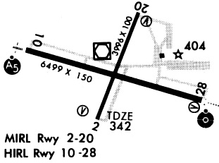
Runways
Runway Summary
| Runways: | 02/20 10/28 |
| Longest Runway: | 10/28 is 6500 ft (1981 m) long |
| Runways with an Instrument Approach: | 10 |
CGI Airport Runway Details
| Runway 02/20 | 3997 ft x 100 ft (1218 m x 30 m) | |
| Runway Length Source: | 3RD PARTY SURVEY as of 07/13/2022 | |
| Surface: | Asphalt/Concrete - Fair condition - No special surface treatment | |
| Runway Pavement Class: | 16 /R/D/W/T | |
| Runway Edge Lights: | Medium Intensity | |
Runway Weight Bearing Capacity (in thousands of pounds) |
||
| Single Wheel Landing Gear: | 45.0 | |
| Dual Wheel Landing Gear: | 60.0 | |
| Dual Tandem Wheel Landing Gear: | 100.0 | |
Runway 02 |
Runway 20 |
|
Elevation: |
341.5 | 335.7 |
Latitude: |
37-13-14.8868N | 37-13-51.7296N |
Longitude: |
089-34-22.2126W | 089-34-04.3380W |
|
Runway True Alignment: |
021 | 201 |
Glide Path Angle: |
4.0 degrees | 3.0 degrees |
Traffic Pattern: |
Left | Left |
Runway Markings Type: |
Nonprecision Instrument | Nonprecision Instrument |
Runway Markings Condition: |
Good | Good |
Object at End: |
TREE | |
Object Height: |
70 | |
Distance from End: |
1500 | |
Object Centerline Offset: |
450 ft. left of centerline | |
Visual Glide Slope Indicators: |
4-Box VASI On Left Side Of Runway | 4-Box VASI On Left Side Of Runway |
Threshold Crossing Height: |
50 | 44 |
Declared Distances |
||
Take Off Run Avbl. (TORA): |
3997 | 3997 |
Take Off Distance Avbl. (TODA): |
3997 | 3997 |
Actual Stop Dist. Avbl. (ASDA): |
3997 | 3997 |
Landing Dist. Avbl. (LDA): |
3997 | 3997 |
| Runway 10/28 | 6500 ft x 150 ft (1981 m x 46 m) | |
| Runway Length Source: | 3RD PARTY SURVEY as of 07/13/2022 | |
| Surface: | Asphalt/Concrete - Fair condition - Saw-cut or plastic grooved | |
| Runway Pavement Class: | 30 /R/D/W/T | |
| Runway Edge Lights: | High Intensity | |
Runway Weight Bearing Capacity (in thousands of pounds) |
||
| Single Wheel Landing Gear: | 93.0 | |
| Dual Wheel Landing Gear: | 125.0 | |
| Dual Tandem Wheel Landing Gear: | 215.0 | |
Runway 10 |
Runway 28 |
|
Elevation: |
336.9 | 340.6 |
Latitude: |
37-13-38.5505N | 37-13-21.0429N |
Longitude: |
089-34-54.2950W | 089-33-36.9684W |
|
Runway True Alignment: |
106 | 286 |
ILS Type: |
ILS/DME | |
Glide Path Angle: |
0.0 degrees | 3.0 degrees |
Traffic Pattern: |
Left | Left |
Runway Markings Type: |
Precision Instrument | Nonprecision Instrument |
Runway Markings Condition: |
Good | Good |
Object at End: |
TREE | |
Object Height: |
160 | |
Distance from End: |
5600 | |
Object Centerline Offset: |
450 ft. left of centerline | |
Visual Glide Slope Indicators: |
2-Box VASI On Left Side Of Runway | |
Runway Visual Range (RVR): |
Touchdown | Rollout |
Approach Light System: |
1,400 Foot Medium Intensity Approach Lighting System With Runway Alignment Indicator Lights | Omnidirectional Approach Lighting System |
Threshold Crossing Height: |
38 | |
Declared Distances |
||
Take Off Run Avbl. (TORA): |
6500 | 6500 |
Take Off Distance Avbl. (TODA): |
6500 | 6500 |
Actual Stop Dist. Avbl. (ASDA): |
6500 | 6500 |
Landing Dist. Avbl. (LDA): |
6500 | 6500 |
Services
Airframe Repair: |
Major |
Powerplant Repair: |
Major |
Fuel Available: |
100LL, Jet A |
Landing Fees: |
No |
Parking: |
Tiedowns available |
Maps & Diagrams
CGI Sectional
Flight Planning
at skyvector.com
at skyvector.com