Location
Latitude: |
41-28-21.7760N (41.472716) |
Longitude: |
085-15-38.8710W (-85.260798) |
Elevation: |
1004.3 feet MSL (306 m MSL) |
Magnetic Variation: |
5.8 W (as of April 2024 from WMM2020 model) |
Time Zone: |
UTC -5.0 (Standard Time) UTC -4.0 (Daylight Savings Time) |
From City: |
02 N.M. N of Kendallville, Indiana |
Found On: |
Chicago Chart |
FAA Region: |
AGL |
Contacts
Manager: |
Publicly owned: |
| JOHN KLINE 363 E. AIRPORT RD. KENDALLVILLE, IN 46755 260-349-0350 |
KENDALLVILLE BOAC 363 E AIRPORT RD KENDALLVILLE, IN 46755 260-349-0350 |
Operations
Airport Status: |
Operational |
Facility Use: |
Public |
Type: |
Airport |
Activation Date: |
11/1946 |
Control tower: |
No |
Attendance (Months/Days/Hours): |
Months/Days/Hours ALL/MON - SAT/0800-1700 |
Boundary ARTCC: |
ZAU (Chicago) |
Responsible ARTCC: |
ZAU (Chicago) |
Lighting Schedule: |
SEE RMK |
Segmented Circle Indicator: |
Yes |
Traffic Pattern Altitude (MSL): |
2004 feet (611 m) |
NOTAMs Facility: |
HUF |
NOTAM-D Service: |
Yes |
International Airport of Entry: |
No |
Customs Landing Rights: |
No |
Military Landing Rights: |
Yes |
Civil/Military Joint Use: |
No |
Based Aircraft
| Single Engine: | 25 |
| Multi Engine: | 1 |
| Gliders: | 7 |
Annual Operations (as of 12/31/2019)
| Total Operations: | 6078 | |
| Air Taxi: | 244 | 4.0% |
| GA Local: | 4072 | 67.0% |
| GA Itinerant: | 1762 | 29.0% |
Communications
| CTAF: | 122.800 |
| Unicom: | 122.800 |
| Approach: | FORT WAYNE 127.2 ;SW/NW OF ACTIVE RWY 127.2 ;SW/NW OF ACTIVE RWY 127.2 ;SW/NW OF ACTIVE RWY 127.2 ;SW/NW OF ACTIVE RWY 127.2 ;SW/NW OF ACTIVE RWY |
| Departure: | FORT WAYNE 127.2 ;SW/NW OF ACTIVE RWY 127.2 ;SW/NW OF ACTIVE RWY 127.2 ;SW/NW OF ACTIVE RWY 127.2 ;SW/NW OF ACTIVE RWY 127.2 ;SW/NW OF ACTIVE RWY |
| AWOS-3P: | 119.925 (260-347-2967) |
- APCH CTL SECTORIZATION BASED UPON FORT WAYNE RWY USAGE.
Fixed Based Operators (FBOs) & Fuel
(Click on a business for detail)
Please help us keep this information up to date. This is a FREE SERVICE just like everything else on Airport Guide! If you see that a business needs to be added, modified, or deleted please fill out our Update Form.
To add, modify, or delete a business click here.
Please help us keep this information up to date. This is a FREE SERVICE just like everything else on Airport Guide! If you see that a business needs to be added, modified, or deleted please fill out our Update Form.
Area Code: 219 |
| Business Name | Frequency | Phone | Fuel Grade |
|---|---|---|---|
| Kendallville Flying Service, Inc.
Update FBO info |
Unicom 122.8 | 347-9260 | 80, 100LL, Jet A |
| Sky Tractors, Inc.
Update FBO info |
347-4444 |
Flight Service Stations
| Primary | Alternate | |
| FSS on Field: | N | |
| FSS Name (ID): | Terre Haute(HUF) | |
| Frequency: | ||
| Toll Free Phone: | 1-800-WX-BRIEF |
Instrument Procedures / Charts
FAA Terminal Procedures valid from 0901Z 03/21/24 to 0901Z 04/18/24.
There are various types of charts available for an airport. They are listed in the Page Type column. Here is a legend for those types:
APD - Airport Diagram
DP - Departure Procedure Charts
HOT - Hot Spots
IAP - Instrument Approach Procedure Charts
MIN - Minimums
STAR - Standard Terminal Arrival Charts
| Page Type | Page Name | Volume | Action Since Last Cycle |
|---|---|---|---|
| IAP | RNAV (GPS) RWY 10 | EC-2 | |
| IAP | RNAV (GPS) RWY 28 | EC-2 | |
| MIN | ALTERNATE MINIMUMS | EC-2 | |
| MIN | TAKEOFF MINIMUMS | EC-2 |
Terminal Procedures are only available for airports in several countries with more being added all the time. If you are looking for a specific country's charts, please send an email to support(at)airportguide.com stating the country name. This will be used to prioritize the implementation.
Navigation Aids (Navaids) near C62
| Dist (NM) | ID | Morse Code | Name | Type | Freq | True Hdg | Mag Hdg |
|---|---|---|---|---|---|---|---|
| 12.7 | ANQ | . _ _ . _ _ . _ | Angola | NDB | 347 | 37 | 43 |
| 17.2 | OLK | _ _ _ . _ . . _ . _ | Webster Lake | VOR | 110.40 | 218 | 224 |
| 17.3 | GW | _ _ . . _ _ | Shenk | NDB | 227 | 124 | 130 |
| 21.8 | IRS | . . . _ . . . . | Sturgis | NDB | 382 | 339 | 345 |
| 29.8 | FWA | . . _ . . _ _ . _ | Fort Wayne | VORTAC | 117.80 | 173 | 179 |
| 29.8 | FWA | . . _ . . _ _ . _ | Fort Wayne Baer | VOT | 111.00 | 173 | 179 |
| 32.7 | HAI | . . . . . _ . . | Three Rivers | NDB | 407 | 333 | 339 |
| 34.6 | GSH | _ _ . . . . . . . . | Goshen | VORTAC | 113.70 | 275 | 281 |
| 38.2 | HHG | . . . . . . . . _ _ . | Huntington | NDB | 417 | 193 | 199 |
| 41.3 | AZ | . _ _ _ . . | Austn | NDB | 371 | 343 | 349 |
| 41.8 | LFD | . _ . . . . _ . _ . . | Litchfield | VOR-DME | 111.20 | 31 | 37 |
| 45.2 | SB | . . . _ . . . | Misha | NDB | 341 | 288 | 294 |
| 46.8 | VFU | . . . _ . . _ . . . _ | Stanley | NDB | 411 | 141 | 147 |
| 47.7 | AZO | . _ _ _ . . _ _ _ | Kalamazoo | DME | 109 | 344 | 350 |
| 49.0 | IWH | . . . _ _ . . . . | Wabash | NDB | 329 | 209 | 215 |
| 50.2 | BTL | _ . . . _ . _ . . | Battle Creek | VORTAC | 109.40 | 0 | 6 |
| 50.7 | GIJ | _ _ . . . . _ _ _ | Gipper | VORTAC | 115.40 | 290 | 295 |
| 51.3 | USE | . . _ . . . . | Fulton | NDB | 375 | 80 | 86 |
| 52.9 | CPB | _ . _ . . _ _ . _ . . . | Culver | NDB | 391 | 253 | 258 |
| 53.5 | BT | _ . . . _ | Batol | NDB | 272 | 3 | 9 |
Nearby Airports with Fuel
Notices to Airmen (NOTAMS)
Remarks
| A110-3 | GLIDER OPS MAY-NOV 0900-SS. |
| A110-5 | FOR CD CTC CHICAGO ARTCC AT 630-906-8921. |
| A17 | EMERG - 574-276-3933. |
| A30-10/28 | 160 FT CROPS N OF CNTRLN ENTIRE LEN. |
| A30A-10 | 5 FT TRRN DOWN SLOPE 100 FT FM RWY END. |
| A43-28 | UNUSBL BYD 9 DEGS RIGHT OF CNTRLN. |
| A81-APT | ACTVT REIL RWY 10 & 28; PAPI RWY 10 & 28; MIRL RWY 10/28 - CTAF. |
Runways
Runway Summary
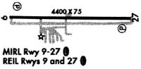
| Runways: | 10/28 |
| Longest Runway: | 10/28 is 4400 ft (1341 m) long |
| Runways with an Instrument Approach: |
C62 Airport Runway Details
| Runway 10/28 | 4400 ft x 75 ft (1341 m x 23 m) | |
| Runway Length Source: | 3RD PARTY SURVEY as of 07/30/2022 | |
| Surface: | Asphalt - Good condition - No special surface treatment | |
| Runway Edge Lights: | Medium Intensity | |
Runway Weight Bearing Capacity (in thousands of pounds) |
||
| Single Wheel Landing Gear: | 12.5 | |
Runway 10 |
Runway 28 |
|
Elevation: |
999.7 | 1004.2 |
Latitude: |
41-28-22.3899N | 41-28-21.1600N |
Longitude: |
085-16-07.7582W | 085-15-09.9847W |
|
Runway True Alignment: |
092 | 272 |
Glide Path Angle: |
3.5 degrees | 3.5 degrees |
Traffic Pattern: |
Left | Left |
Runway Markings Type: |
Nonprecision Instrument | Nonprecision Instrument |
Runway Markings Condition: |
Good | Good |
Object at End: |
TREES | TREES |
Object Height: |
40 | 40 |
Distance from End: |
945 | 990 |
Object Centerline Offset: |
250 ft. left of centerline | 140 ft. right of centerline |
Visual Glide Slope Indicators: |
2-Light PAPI On Left Side Of Runway | 2-Light PAPI On Left Side Of Runway |
REIL: |
Yes | Yes |
Touchdown Lights: |
No | No |
Centerline Lights: |
No | No |
Threshold Crossing Height: |
28 | 31 |
Services
Airframe Repair: |
Major |
Powerplant Repair: |
Major |
Fuel Available: |
100LL, Jet A |
Landing Fees: |
No |
Parking: |
Hangars and tiedowns available |
Other Services: |
Great place, not open 24 hours, tie downs, and open T hangers |
Maps & Diagrams
C62 Sectional
Flight Planning
at skyvector.com
at skyvector.com