Location
Latitude: |
71-17-05.5000N (71.284861) |
Longitude: |
156-46-06.9000W (-156.768583) |
Elevation: |
48.9 feet MSL (15 m MSL) |
Magnetic Variation: |
11.3 E (as of April 2024 from WMM2020 model) |
Time Zone: |
UTC -9.0 (Standard Time) UTC -8.0 (Daylight Savings Time) |
From City: |
00 N.M. SE of Barrow, Alaska |
Found On: |
Point Barrow Chart |
FAA Region: |
AAL |
Contacts
Manager: |
Publicly owned: |
| JOHN OLSEN 30651 EMAIKSOUN ROAD UTQIAGVIK, AK 99723 907-852-5851 |
ALASKA DOT&PF NORTHERN REGION 2301 PEGER RD FAIRBANKS, AK 99701 907-451-2206 |
Operations
Airport Status: |
Operational |
Facility Use: |
Public |
Type: |
Airport |
Control tower: |
No |
Attendance (Months/Days/Hours): |
Months/Days/Hours ALL/ALL/0600-2030 |
Boundary ARTCC: |
ZAN (Anchorage) |
Responsible ARTCC: |
ZAN (Anchorage) |
Lighting Schedule: |
SEE RMK |
Segmented Circle Indicator: |
Yes |
Traffic Pattern Altitude (MSL): |
1049 feet (320 m) |
NOTAMs Facility: |
BRW |
NOTAM-D Service: |
Yes |
International Airport of Entry: |
No |
Customs Landing Rights: |
No |
Military Landing Rights: |
Yes |
Civil/Military Joint Use: |
No |
Aircraft Rescue and Firefighting: |
Class I ARFF Index: B Air Carrier Service: Scheduled Certification Date: 03/2005 |
Based Aircraft
| Single Engine: | 3 |
| Multi Engine: | 1 |
| Jet Engine: | 1 |
| GA Helicopters: | 3 |
Annual Operations (as of 12/31/2018)
| Total Operations: | 12010 | |
| Commercial: | 1460 | 12.2% |
| Air Taxi: | 6000 | 50.0% |
| GA Local: | 3000 | 25.0% |
| GA Itinerant: | 1500 | 12.5% |
| Military Aircraft: | 50 | 0.4% |
Communications
| CTAF: | 123.600 |
| Approach: | ANCHORAGE ARTCC |
| Departure: | ANCHORAGE ARTCC |
| ATIS: | Hrs: 24. |
| ASOS: | 132.150 (907-852-3112) |
| AFIS: | 132.15 |
- COMMUNICATIONS PRVDD BY BARROW FSS ON FREQ 123.6 (CTAF).
- APCH/DEP SVC PRVDD BY ANCHORAGE ARTCC ON FREQS 135.3/239.25 (BARROW RCAG).
- AFIS FREQUENCY 132.15. OPERATES SAME HRS AS BRW FSS, 0600-2200; OT CTC FAIRBANKS FSS.
Fixed Based Operators (FBOs) & Fuel
(Click on a business for detail)
Please help us keep this information up to date. This is a FREE SERVICE just like everything else on Airport Guide! If you see that a business needs to be added, modified, or deleted please fill out our Update Form.
To add, modify, or delete a business click here.
Please help us keep this information up to date. This is a FREE SERVICE just like everything else on Airport Guide! If you see that a business needs to be added, modified, or deleted please fill out our Update Form.
Area Code: 907 |
| Business Name | Frequency | Phone | Fuel Grade |
|---|---|---|---|
| Cape Smythe Air Service
Website Update FBO info |
Unicom 133.55 | 852-8333 | 100LL, Jet A |

|
 Independent |
100LL - 3.25 USD per gallon on 8/18/01 |
24 Hour Self Serve Credit Card Pumps |
|
|
Independent |
Jet A - 3.00 USD per gallon on 8/18/01 |
24 Hour Self Serve Credit Card Pumps |
| Eskimos, Inc.
Update FBO info |
852-3835, 852-9477 | 100LL, Jet A | |
|
|
Independent |
100LL - 3.22 USD per gallon on 8/18/01 |
Trucks |
|
|
Independent |
Jet A - 2.48 USD per gallon on 8/18/01 |
Trucks |
Flight Service Stations
| Primary | Alternate | |
| FSS on Field: | Y | |
| FSS Name (ID): | Barrow(BRW) | Fairbanks (FAI) |
| Frequency: | ||
| Toll Free Phone: | LC852-2511 | 1-866-248-6516 |
Instrument Procedures / Charts
FAA Terminal Procedures valid from 0901Z 03/21/24 to 0901Z 04/18/24.
There are various types of charts available for an airport. They are listed in the Page Type column. Here is a legend for those types:
APD - Airport Diagram
DP - Departure Procedure Charts
HOT - Hot Spots
IAP - Instrument Approach Procedure Charts
MIN - Minimums
STAR - Standard Terminal Arrival Charts
| Page Type | Page Name | Volume | Action Since Last Cycle |
|---|---|---|---|
| IAP | ILS OR LOC RWY 08 | AK-1 | |
| IAP | LOC BC RWY 26 | AK-1 | |
| IAP | RNAV (GPS) RWY 08 | AK-1 | |
| IAP | RNAV (GPS) RWY 26 | AK-1 | |
| IAP | VOR RWY 26 | AK-1 | Changed |
| MIN | ALTERNATE MINIMUMS | AK-1 | |
| MIN | TAKEOFF MINIMUMS | AK-1 |
Terminal Procedures are only available for airports in several countries with more being added all the time. If you are looking for a specific country's charts, please send an email to support(at)airportguide.com stating the country name. This will be used to prioritize the implementation.
Navigation Aids (Navaids) near BRW
| Dist (NM) | ID | Morse Code | Name | Type | Freq | True Hdg | Mag Hdg |
|---|---|---|---|---|---|---|---|
| 0.3 | VIR | . . . _ . . . _ . | Browerville | NDB | 281 | 237 | 226 |
| 0.8 | BRW | _ . . . . _ . . _ _ | Barrow | VOR-DME | 116.20 | 208 | 197 |
| 50.6 | ATK | . _ _ _ . _ | Atqasuk | NDB | 350 | 195 | 184 |
| 74.4 | UKK | . . _ _ . _ _ . _ | Wainwright Village | NDB | 338 | 240 | 229 |
Nearby Airports with Fuel
| Dist (NM) | Name (Airport IDs) | True Hdg | Mag Hdg | Fuel Grade |
|---|
Notices to Airmen (NOTAMS)
Remarks
| A110-1 | SNOW REMOVAL, WILDLIFE CTL, COND RPRTG & ARPT MAINT SVC AVBL DURG MAINT DUTY HR 0600-2030; AFT HR - AMGR. |
| A110-10 | MAIN RAMP TXL NON STD WINGTIP CLNC; RWY BACK TAXI WHEN LRG ACFT PRKD ON MAIN RAMP. |
| A110-13 | TSA REG ARPT; SEE 49 CFR 1542. GATES & DOORS MUST BE SECURED ALL TIMES. TSNT - AMGR OR BRW FSS FOR INFO. |
| A110-2 | WATERFOWL INVOF ARPT SPRING-FALL. |
| A110-3 | ARPT SAND LRGR GRADATION THAN FAA RCMDD/SEE AC150/5200-30. |
| A110-7 | RCMD LRGR ACFT USE ELEPHANT EAR TO TURN AROUND. |
| A110-8 | WX CAMERA AVBL ON INTERNET AT HTTPS://WEATHERCAMS.FAA.GOV |
| A110-9 | WSO - 907-852-6484. |
| A26 | CLSD TO ACR OPS MORE THAN 30 PAX SEATS EXCP PPR IN WRITING - AMGR PO BOX 367 BARROW AK 99723. |
| A81-APT | ACTVT MALSR RWY 08; REIL RWY 26 - CTAF. HIRL RWY 08/26 PRESET LOW INTST - INCR INTST BRW FSS 0600-2200; AFT HR - CTAF. PAPI RWY 08 & 26 ON CONSLY. |
| A81-BCN | ROTG BCN ON CONSLY. |
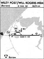
Runways
Runway Summary
| Runways: | 08/26 |
| Longest Runway: | 08/26 is 7100 ft (2164 m) long |
| Runways with an Instrument Approach: | 08 |
BRW Airport Runway Details
| Runway 08/26 | 7100 ft x 150 ft (2164 m x 46 m) | |
| Runway Length Source: | 3RD PARTY SURVEY as of 10/11/2012 | |
| Surface: | Asphalt - Fair condition - Saw-cut or plastic grooved | |
| Runway Pavement Class: | 43 /F/A/X/U | |
| Runway Edge Lights: | High Intensity | |
Runway Weight Bearing Capacity (in thousands of pounds) |
||
| Single Wheel Landing Gear: | 75.0 | |
| Dual Wheel Landing Gear: | 160.0 | |
| Dual Tandem Wheel Landing Gear: | 300.0 | |
Runway 08 |
Runway 26 |
|
Elevation: |
48.6 | 37.4 |
Latitude: |
71-17-05.5255N | 71-17-05.5607N |
Longitude: |
156-47-55.5967W | 156-44-18.1378W |
|
Runway True Alignment: |
090 | 270 |
ILS Type: |
ILS/DME | |
Glide Path Angle: |
3.0 degrees | 3.0 degrees |
Traffic Pattern: |
Right | Left |
Runway Markings Type: |
Precision Instrument | Precision Instrument |
Runway Markings Condition: |
Good | Good |
Object at End: |
ANT | |
Object Height: |
9 | |
Object Marked/Lighted?: |
Lighted | |
Distance from End: |
1500 | 380 |
Object Centerline Offset: |
0 ft. left and right of centerline | 200 ft. right of centerline |
Visual Glide Slope Indicators: |
4-Light PAPI On Right Side Of Runway | 4-Light PAPI On Left Side Of Runway |
Runway Visual Range (RVR): |
Touchdown | Rollout |
Approach Light System: |
1,400 Foot Medium Intensity Approach Lighting System With Runway Alignment Indicator Lights | |
REIL: |
Yes | |
Threshold Crossing Height: |
51 | 50 |
Threshold Elevation: |
48.7 | 39.1 |
Displaced Threshold: |
600 | 600 |
Threshold Latitude: |
71-17-05.5312N | 71-17-05.5604N |
Threshold Longitude: |
156-47-37.2221W | 156-44-36.5152W |
Declared Distances |
||
Take Off Run Avbl. (TORA): |
7100 | 7100 |
Take Off Distance Avbl. (TODA): |
7100 | 7100 |
Actual Stop Dist. Avbl. (ASDA): |
6500 | 6500 |
Landing Dist. Avbl. (LDA): |
5900 | 5900 |
Services
Airframe Repair: |
Minor |
Powerplant Repair: |
Minor |
Fuel Available: |
100LL, Jet A-1 |
Landing Fees: |
No |
Parking: |
Hangars available |
Maps & Diagrams
BRW Sectional
Flight Planning
at skyvector.com
at skyvector.com