Location
Latitude: |
35-42-03.2000N (35.700889) |
Longitude: |
101-23-37.2000W (-101.393667) |
Elevation: |
3055.2 feet MSL (931 m MSL) |
Magnetic Variation: |
5.4 E (as of April 2024 from WMM2020 model) |
Time Zone: |
UTC -6.0 (Standard Time) UTC -5.0 (Daylight Savings Time) |
From City: |
02 N.M. N of Borger, Texas |
Found On: |
Dallas-Ft Worth Chart |
FAA Region: |
ASW |
Contacts
Manager: |
Publicly owned: |
| DENNIS O'BRYANT BOX 3470 BORGER, TX 79008 806-273-0137 |
HUTCHINSON COUNTY COUNTY COURTHOUSE STINNETT, TX 79083 806-878-4000 |
Operations
Airport Status: |
Operational |
Facility Use: |
Public |
Type: |
Airport |
Activation Date: |
10/1950 |
Control tower: |
No |
Attendance (Months/Days/Hours): |
Months/Days/Hours ALL/ALL/0800-1800 |
Boundary ARTCC: |
ZAB (Albuquerque) |
Responsible ARTCC: |
ZAB (Albuquerque) |
Lighting Schedule: |
SEE RMK |
Segmented Circle Indicator: |
Yes |
Traffic Pattern Altitude (MSL): |
4055 feet (1236 m) |
NOTAMs Facility: |
BGD |
NOTAM-D Service: |
Yes |
International Airport of Entry: |
No |
Customs Landing Rights: |
No |
Military Landing Rights: |
Yes |
Civil/Military Joint Use: |
No |
Based Aircraft
| Single Engine: | 16 |
| Multi Engine: | 1 |
| GA Helicopters: | 1 |
Annual Operations (as of 09/15/2021)
| Total Operations: | 6010 | |
| GA Local: | 4000 | 66.6% |
| GA Itinerant: | 2000 | 33.3% |
| Military Aircraft: | 10 | 0.2% |
Communications
| CTAF: | 123.000 |
| Unicom: | 123.000 |
| Approach: | AMARILLO 119.5 119.5 119.5 119.5 ALBUQUERQUE ARTCC |
| Departure: | AMARILLO 119.5 119.5 119.5 119.5 ALBUQUERQUE ARTCC |
| ASOS: | 118.325 (806-274-7318) |
- APCH/DEP SVC PRVDD BY ALBUQUERQUE ARTCC (ZAB) ON FREQS 127.85/285.475 (AMARILLO RCAG) WHEN AMARILLO APCH CTL (AMA) CLSD.
Fixed Based Operators (FBOs) & Fuel
(Click on a business for detail)
Please help us keep this information up to date. This is a FREE SERVICE just like everything else on Airport Guide! If you see that a business needs to be added, modified, or deleted please fill out our Update Form.
To add, modify, or delete a business click here.
Please help us keep this information up to date. This is a FREE SERVICE just like everything else on Airport Guide! If you see that a business needs to be added, modified, or deleted please fill out our Update Form.
Area Code: 806 |
| Business Name | Frequency | Phone | Fuel Grade |
|---|---|---|---|
| Hutchinson County Airport
Update FBO info |
Unicom 123.0 | 273-0137, -0138 | 100LL, Jet A |
Flight Service Stations
| Primary | Alternate | |
| FSS on Field: | N | |
| FSS Name (ID): | Fort Worth(FTW) | |
| Frequency: | ||
| Toll Free Phone: | 1-800-WX-BRIEF |
Instrument Procedures / Charts
FAA Terminal Procedures valid from 0901Z 03/21/24 to 0901Z 04/18/24.
There are various types of charts available for an airport. They are listed in the Page Type column. Here is a legend for those types:
APD - Airport Diagram
DP - Departure Procedure Charts
HOT - Hot Spots
IAP - Instrument Approach Procedure Charts
MIN - Minimums
STAR - Standard Terminal Arrival Charts
| Page Type | Page Name | Volume | Action Since Last Cycle |
|---|---|---|---|
| IAP | RNAV (GPS) RWY 17 | SC-2 | |
| IAP | RNAV (GPS) RWY 35 | SC-2 | |
| MIN | ALTERNATE MINIMUMS | SC-2 | |
| MIN | TAKEOFF MINIMUMS | SC-2 |
Terminal Procedures are only available for airports in several countries with more being added all the time. If you are looking for a specific country's charts, please send an email to support(at)airportguide.com stating the country name. This will be used to prioritize the implementation.
Navigation Aids (Navaids) near BGD
| Dist (NM) | ID | Morse Code | Name | Type | Freq | True Hdg | Mag Hdg |
|---|---|---|---|---|---|---|---|
| 6.4 | BGD | _ . . . _ _ . _ . . | Borger | TACAN | 108.60 | 5 | 360 |
| 20.3 | PPA | . _ _ . . _ _ . . _ | Pampa | NDB | 368 | 105 | 100 |
| 31.7 | PNH | . _ _ . _ . . . . . | Panhandle | VORTAC | 116.60 | 208 | 203 |
| 38.9 | AM | . _ _ _ | Pande | NDB | 251 | 211 | 206 |
| 53.0 | PYX | . _ _ . _ . _ _ _ . . _ | Perryton | NDB | 266 | 36 | 31 |
| 60.5 | GUY | _ _ . . . _ _ . _ _ | Guymon | NDB | 275 | 354 | 349 |
| 60.7 | DHT | _ . . . . . . _ | Dalhart | VORTAC | 112.00 | 293 | 287 |
| 68.1 | HRX | . . . . . _ . _ . . _ | Hereford | NDB | 341 | 222 | 216 |
| 78.7 | LB | . _ . . _ . . . | Panck | NDB | 383 | 15 | 10 |
| 81.5 | EHA | . . . . . . _ | Elkhart | NDB | 377 | 343 | 337 |
| 83.0 | MMB | _ _ _ _ _ . . . | Mitbee | VORTAC | 115.60 | 61 | 56 |
| 83.2 | LBL | . _ . . _ . . . . _ . . | Liberal | TACAN | 112.30 | 14 | 9 |
| 87.8 | HQG | . . . . _ _ . _ _ _ . | Hugoton | NDB | 365 | 0 | 355 |
| 88.5 | SYO | . . . _ . _ _ _ _ _ | Sayre | VORTAC | 115.20 | 103 | 98 |
| 96.1 | CAO | _ . _ . . _ _ _ _ | Clayton | NDB | 332 | 298 | 292 |
| 96.6 | CDS | _ . _ . _ . . . . . | Childress | VORTAC | 117.00 | 145 | 140 |
| 98.8 | PVW | . _ _ . . . . _ . _ _ | Plainview | VOR-DME | 112.90 | 191 | 186 |
Nearby Airports with Fuel
Notices to Airmen (NOTAMS)
Remarks
| A110-1 | FOR CD CTC ALBUQUERQUE ARTCC AT 505-856-4861. |
| A110-2 | RWY 21, 100 FT DROP-OFF, 95 FT DSTC. |
| A110-3 | RWY 3, 40 FT DROP-OFF, 150 FT DSTC. |
| A58-03 | 15 FT TREE, 130 FT DSTC, 95 FT L. |
| A58-17 | 10 FT BRUSH, 82 FT DSTC, 182 FT R. |
| A81-APT | ACTVT PAPI RWYS 17 & 35; MIRL RWYS 03/21 & 17/35 - CTAF. |
Runways
Runway Summary
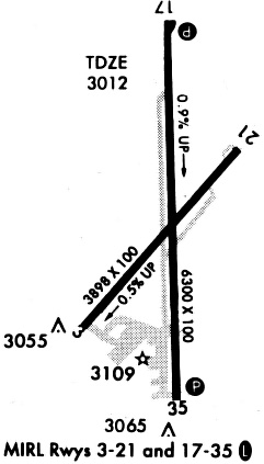
| Runways: | 03/21 17/35 |
| Longest Runway: | 17/35 is 6299 ft (1920 m) long |
| Runways with an Instrument Approach: |
BGD Airport Runway Details
| Runway 03/21 | 3897 ft x 100 ft (1188 m x 30 m) | |
| Runway Length Source: | 3RD PARTY SURVEY as of 07/10/2014 | |
| Surface: | Asphalt - Fair condition - No special surface treatment | |
| Runway Edge Lights: | Medium Intensity | |
Runway Weight Bearing Capacity (in thousands of pounds) |
||
| Single Wheel Landing Gear: | 60.0 | |
| Dual Wheel Landing Gear: | 100.0 | |
Runway 03 |
Runway 21 |
|
Elevation: |
3035.3 | 3017.2 |
Latitude: |
35-41-45.6931N | 35-42-15.2653N |
Longitude: |
101-23-53.6583W | 101-23-23.3654W |
|
Runway True Alignment: |
040 | 220 |
Glide Path Angle: |
0.0 degrees | 0.0 degrees |
Traffic Pattern: |
Left | Left |
Runway Markings Type: |
Basic | Basic |
Runway Markings Condition: |
Fair | Fair |
Object at End: |
TREES | |
Object Height: |
48 | |
Distance from End: |
2350 | |
Object Centerline Offset: |
0 ft. left and right of centerline |
| Runway 17/35 | 6299 ft x 100 ft (1920 m x 30 m) | |
| Runway Length Source: | 3RD PARTY SURVEY as of 07/10/2014 | |
| Surface: | Asphalt - Fair condition - No special surface treatment | |
| Runway Edge Lights: | Medium Intensity | |
Runway Weight Bearing Capacity (in thousands of pounds) |
||
| Single Wheel Landing Gear: | 60.0 | |
| Dual Wheel Landing Gear: | 100.0 | |
Runway 17 |
Runway 35 |
|
Elevation: |
2998.3 | 3055.2 |
Latitude: |
35-42-36.0420N | 35-41-33.7861N |
Longitude: |
101-23-37.4475W | 101-23-35.2827W |
|
Runway True Alignment: |
178 | 358 |
Glide Path Angle: |
3.0 degrees | 3.0 degrees |
Traffic Pattern: |
Left | Left |
Runway Markings Type: |
Nonprecision Instrument | Nonprecision Instrument |
Runway Markings Condition: |
Good | Good |
Object at End: |
TREES | |
Object Height: |
40 | |
Distance from End: |
1000 | |
Object Centerline Offset: |
0 ft. left and right of centerline | |
Visual Glide Slope Indicators: |
4-Light PAPI On Left Side Of Runway | 4-Light PAPI On Right Side Of Runway |
Threshold Crossing Height: |
58 | 41 |
Services
Fuel Available: |
100LL, Jet A |
Landing Fees: |
No |
Parking: |
Tiedowns available |
Maps & Diagrams
BGD Sectional
Flight Planning
at skyvector.com
at skyvector.com