Location
Latitude: |
47-31-47.9000N (47.529972) |
Longitude: |
122-18-07.0000W (-122.301944) |
Elevation: |
21.6 feet MSL (7 m MSL) |
Magnetic Variation: |
15.2 E (as of April 2024 from WMM2020 model) |
Time Zone: |
UTC -8.0 (Standard Time) UTC -7.0 (Daylight Savings Time) |
From City: |
04 N.M. S of Seattle, Washington |
Found On: |
Seattle Chart |
FAA Region: |
ANM |
Contacts
Manager: |
Publicly owned: |
| JOHN PARROTT, AAE 7277 PERIMETER ROAD SOUTH SEATTLE, WA 98108-3844 206-296-7334 |
KING COUNTY 516 THIRD AVE SEATTLE, WA 98104 (206) 296-7380 |
Operations
Airport Status: |
Operational |
Facility Use: |
Public |
Type: |
Airport |
Activation Date: |
11/1938 |
Control tower: |
Yes |
Attendance (Months/Days/Hours): |
Months/Days/Hours ALL/ALL/ALL |
Boundary ARTCC: |
ZSE (Seattle) |
Responsible ARTCC: |
ZSE (Seattle) |
Lighting Schedule: |
SEE RMK |
Segmented Circle Indicator: |
No |
Traffic Pattern Altitude (MSL): |
1022 feet (312 m) |
NOTAMs Facility: |
BFI |
NOTAM-D Service: |
Yes |
International Airport of Entry: |
Yes |
Customs Landing Rights: |
No |
Military Landing Rights: |
Yes |
Civil/Military Joint Use: |
No |
Aircraft Rescue and Firefighting: |
Class IV ARFF Index: A Air Carrier Service: Scheduled Certification Date: 01/1974 |
Based Aircraft
| Single Engine: | 229 |
| Multi Engine: | 40 |
| Jet Engine: | 88 |
| GA Helicopters: | 26 |
| Gliders: | 1 |
Annual Operations (as of 01/01/2019)
| Total Operations: | 183268 | |
| Commercial: | 10142 | 5.5% |
| Air Taxi: | 27913 | 15.2% |
| GA Local: | 49537 | 27.0% |
| GA Itinerant: | 94500 | 51.6% |
| Military Aircraft: | 1176 | 0.6% |
Communications
| Unicom: | 122.950 |
| Tower: | BOEING 118.3 ;RWY 14L/32R 120.6 ;RWY 14R/32L & ALL IFR 257.8 Hrs: 24 |
| Clearance Del.: | 132.4 |
| Ground: | 121.9 |
| Approach: | SEATTLE |
| Departure: | SEATTLE |
| ATIS: | 127.75 Hrs: 24 |
| ASOS: | (206-658-6435) |
- FREQ 121.5 NOT AVBL.
- FREQ 118.3 (312-127) AND DEPS RWY 14L/32R.
- FREQ 120.6 (128-311) AND DEPS RWY 14R/32L AND ALL JETS; HEAVY ACFT AND IFR ARRS.
Fixed Based Operators (FBOs) & Fuel
(Click on a business for detail)
Please help us keep this information up to date. This is a FREE SERVICE just like everything else on Airport Guide! If you see that a business needs to be added, modified, or deleted please fill out our Update Form.
To add, modify, or delete a business click here.
Please help us keep this information up to date. This is a FREE SERVICE just like everything else on Airport Guide! If you see that a business needs to be added, modified, or deleted please fill out our Update Form.
Area Code: 206 |
| Business Name | Frequency | Phone | Fuel Grade |
|---|---|---|---|
| Aeroflight Executive Services, Inc.
Update FBO info |
Unicom 122.95, Arinc 131.75 | 763-4718 | 100LL, Jet A |
| Air Tech
Update FBO info |
767-6040 | ||
| American Avionics, Inc.
Update FBO info |
763-8530 | ||
| Classic Helicopters
Update FBO info |
767-0515 | ||
| Flight Center
Update FBO info |
Unicom 122.95, Arinc 131.025 | 768-0800, 800-768-1101 | 100LL, Jet A |
| Galvin Flying Service, Inc.
Update FBO info |
Unicom 122.95, Arinc 129.025 | 763-0350, 800-341-4102 | 100LL, Jet A |
| Museum of Flight/Wings Cafe
Update FBO info |
764-5700 | ||
| National Aviation
Update FBO info |
762-7278 | ||
| Signature Flight Support
Update FBO info |
Arinc: 129.025 | +1 206 763 0350 | |
| The Aviator's Store
Update FBO info |
763-0666 | ||
| Washington Avionics
Update FBO info |
762-0190 | ||
| Wings Aloft, Inc.
Update FBO info |
763-2113 | 100LL |
Flight Service Stations
| Primary | Alternate | |
| FSS on Field: | N | |
| FSS Name (ID): | Seattle(SEA) | |
| Frequency: | ||
| Toll Free Phone: | 1-800-WX-BRIEF |
Instrument Procedures / Charts
FAA Terminal Procedures valid from 0901Z 03/21/24 to 0901Z 04/18/24.
There are various types of charts available for an airport. They are listed in the Page Type column. Here is a legend for those types:
APD - Airport Diagram
DP - Departure Procedure Charts
HOT - Hot Spots
IAP - Instrument Approach Procedure Charts
MIN - Minimums
STAR - Standard Terminal Arrival Charts
| Page Type | Page Name | Volume | Action Since Last Cycle |
|---|---|---|---|
| APD | AIRPORT DIAGRAM | NW-1 | |
| DP | CBAIN ONE (RNAV) | NW-1 | |
| DP | KENT EIGHT | NW-1 | |
| DP | KENT EIGHT[DELIMITER] CONT.1 | NW-1 | |
| DP | NEEDLE ONE | NW-1 | |
| DP | NRVNA ONE (RNAV) | NW-1 | |
| HOT | HOT SPOT | NW-1 | |
| IAP | HARBOR VISUAL RWY 14R | NW-1 | |
| IAP | ILS OR LOC RWY 14R | NW-1 | |
| IAP | ILS OR LOC RWY 32L | NW-1 | |
| IAP | RNAV (GPS) Y RWY 14R | NW-1 | |
| IAP | RNAV (GPS) Y RWY 32L | NW-1 | |
| IAP | RNAV (RNP) Z RWY 14R | NW-1 | |
| IAP | RNAV (RNP) Z RWY 32L | NW-1 | |
| MIN | ALTERNATE MINIMUMS | NW-1 | |
| MIN | TAKEOFF MINIMUMS | NW-1 | |
| STAR | CHINS FIVE | NW-1 | |
| STAR | CHINS FIVE[DELIMITER] CONT.1 | NW-1 | |
| STAR | GLASR THREE | NW-1 | |
| STAR | GLASR THREE[DELIMITER] CONT.1 | NW-1 | |
| STAR | JAWBN SIX | NW-1 | |
| STAR | OLYMPIA TWO | NW-1 | |
| STAR | OLYMPIA TWO[DELIMITER] CONT.1 | NW-1 | |
| STAR | SKYKO ONE | NW-1 |
Terminal Procedures are only available for airports in several countries with more being added all the time. If you are looking for a specific country's charts, please send an email to support(at)airportguide.com stating the country name. This will be used to prioritize the implementation.
Navigation Aids (Navaids) near BFI
| Dist (NM) | ID | Morse Code | Name | Type | Freq | True Hdg | Mag Hdg |
|---|---|---|---|---|---|---|---|
| 0.1 | BFI | _ . . . . . _ . . . | Seattle | VOT | 108.60 | 244 | 229 |
| 0.3 | HPK | . . . . . _ _ . _ . _ | Parkk | NDB | 281 | 305 | 290 |
| 4.1 | RNT | . _ . _ . _ | Renton | NDB | 353 | 120 | 105 |
| 4.5 | SEA | . . . . . _ | Seattle-Tacoma | VOT | 117.50 | 179 | 164 |
| 5.7 | SEA | . . . . . _ | Seattle | VORTAC | 116.80 | 183 | 168 |
| 7.1 | BF | _ . . . . . _ . | Nolla | NDB | 362 | 330 | 315 |
| 18.6 | PWT | . _ _ . . _ _ _ | Kitsap | NDB | 206 | 263 | 248 |
| 22.9 | CAN | _ . _ . . _ _ . | Carney | NDB | 274 | 251 | 236 |
| 23.4 | PAE | . _ _ . . _ . | Paine | VOR-DME | 110.60 | 2 | 347 |
| 24.0 | TCM | _ _ . _ . _ _ | Mcchord | TACAN | 109.60 | 197 | 182 |
| 25.9 | GRF | _ _ . . _ . . . _ . | Graye | NDB | 216 | 208 | 193 |
| 33.0 | LAC | . _ . . . _ _ . _ . | Lacomas | NDB | 328 | 198 | 183 |
| 33.3 | AW | . _ . _ _ | Waton | NDB | 382 | 10 | 355 |
| 36.1 | MNC | _ _ _ . _ . _ . | Mason County | NDB | 348 | 242 | 227 |
| 41.5 | OLM | _ _ _ . _ . . _ _ | Olympia | VORTAC | 113.40 | 216 | 201 |
| 46.1 | CVV | _ . _ . . . . _ . . . _ | Penn Cove | VOR-DME | 117.20 | 338 | 323 |
| 51.6 | NUW | _ . . . _ . _ _ | Whidbey Island | TACAN | 113.80 | 343 | 328 |
| 56.5 | BVS | _ . . . . . . _ . . . | Skagit/Bay View | NDB | 240 | 355 | 340 |
| 57.5 | NOW | _ . _ _ _ . _ _ | Ediz Hook | NDB | 338 | 309 | 294 |
| 62.1 | OPZ | _ _ _ . _ _ . _ _ . . | Lopez Island | NDB | 356 | 336 | 321 |
Nearby Airports with Fuel
Notices to Airmen (NOTAMS)
Remarks
| A110-10 | GA ITNRNT/TSNT PRKG AVBL. CTC ARPT OPS 206-296-7334. |
| A110-11 | TWR 80 FT AGL LCTD 1200 FT N AND 900 FT W OF THLD RY 14R. |
| A110-13 | FOR NOISE ABATEMENT PROCEDURES, CONTACT NOISE OFFICE AT (206) 296-7334. |
| A110-14 | EXTENSIVE HELICOPTER TRAINING ACTIVITY ON TAXIWAY B. |
| A110-15 | FOR MUSEUM OF FLT TSNT ACFT PRKG, PPR, CALL MUSEUM OF FLT SCTY (206) 920-9770. |
| A110-16 | TAXIWAY ZULU AND 880' SPECIAL USE PAVEMENT AVAILABLE 72 HOURS PRIOR PERMISSION REQUIRED. CONTACT AIRPORT OPERATIONS 206-296-7334. |
| A110-2 | TPA RWY 14L/32R 1000 MSL; RWY 14R/32L 800 MSL. |
| A110-22 | EMERG FREQ 121.5 NOT MNT AT TWR. |
| A110-23 | FOR BOEING MILITARY FLIGHT CENTER RAMP PERMISSION, CTC RAMP COORDINATOR 206-225-0989, 72 HOUR PRIOR PERMISSION REQUIRED, 96 HOUR PRIOR PERMISSION REQUIRED IF ORDNANCES/MUNITIONS INSTALLED OR IF ORDNANCES/MUNITIONS STORAGE IS REQUIRED. LIMITED LOX SERVICE MEETING MIL-PRF-27210J, TYPE II AVAILABLE FOR MILITARY FLIGHT CENTER TRANSIENT AIRCRAFT, CONTACT 96 HOURS PRIOR WITH NEEDED VOLUME AND AIRCRAFT TYPE. PRIOR TO ARRIVAL ONTO BOEING COMMERCIAL AIRPLANE RAMP, CTC BOEING SEATTLE AT 123.425 OR CALL 206-662-4500. ADVANCED PERMISSION TO ACCESS BOEING COMMERCIAL AIRPLANE RAMP ONLY, CTC 206-544-5900 M-F 1600Z-0000Z. |
| A110-25 | FOR CD WHEN ATCT IS CLSD CTC SEATTLE APCH AT 206-214-4722. |
| A110-26 | VFR PILOTS SHLD REVIEW & EXPC VFR PROCS PRIOR TO ARR/DEP. |
| A110-3 | TOUCH AND GO LNDGS PROHIBITED 2200-0700. |
| A110-5 | BIRD FLOCKS WITHIN ARPT VICINITY. - CHECK LOCAL ADVISORIES. |
| A110-6 | FLIGHT NOTIFICATION SERVICE (ADCUS) AVBL. |
| A110-7 | 14' ANT (MKD/LGTD) 230' FM RY 14L END 125' R. |
| A110-8 | TWY A1 & TWY A FROM A1-A3 RSTRD TO ACFT UP TO 150000 LBS AND LESS THAN 108 FT WINGSPAN. |
| A110-9 | TWYS A2; B2; & A11 RSTD TO ACFT UP TO 60000 LBS. TWYS A3; A5; & A8 RSTD TO ACFT UP TO 12500 LBS. |
| A14 | JPARROTT@KINGCOUNTY.GOV. |
| A30-14L/32R | RUNWAY 14L/32R NOT AVAILABLE FOR AIR CARRIER OPERATIONS |
| A35-14L/32R | LTD TO USE BY ACFT UP TO 12,500 LBS. |
| A57-32L | APCH SLOPE 40:1 TO DSPLCD THLD. |
| A57-32R | APCH RATIO 27:1 FM DSPLCD THLD. |
| A58-32L | FENCE/ROAD/POLES/RR TRACKS WITHIN EAST EDGE OF PRIM SFC. |
| A81-APT | HIRL RY 14R/32L OPEN DUSK-DAWN. MIRL RY 14L/32R NOT OPER 0600-1500Z++. |
| E111 | ESTABD PRIOR TO 1959. |
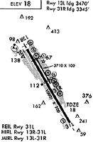
Runways
Runway Summary
| Runways: | 14L/32R 14R/32L |
| Longest Runway: | 14R/32L is 10007 ft (3050 m) long |
| Runways with an Instrument Approach: | 14R, 32L |
BFI Airport Runway Details
| Runway 14L/32R | 3709 ft x 100 ft (1131 m x 30 m) | |
| Runway Length Source: | 3RD PARTY SURVEY as of 02/02/2016 | |
| Surface: | Asphalt - Fair condition - Saw-cut or plastic grooved | |
| Runway Pavement Class: | 71 /F/A/X/T | |
| Runway Edge Lights: | Medium Intensity | |
Runway Weight Bearing Capacity (in thousands of pounds) |
||
| Single Wheel Landing Gear: | 120.0 | |
| Dual Wheel Landing Gear: | 250.0 | |
| Dual Tandem Wheel Landing Gear: | 550.0 | |
| Dual Dual Tandem Wheel Landing Gear: | 1109.0 | |
Runway 14L |
Runway 32R |
|
Elevation: |
17.4 | 17.1 |
Latitude: |
47-32-16.8657N | 47-31-45.0967N |
Longitude: |
122-18-26.8569W | 122-18-00.0020W |
|
Runway True Alignment: |
150 | 330 |
Glide Path Angle: |
3.0 degrees | 3.0 degrees |
Traffic Pattern: |
Left | Right |
Runway Markings Type: |
Basic | Basic |
Runway Markings Condition: |
Good | Good |
Object at End: |
TREE | |
Object Height: |
210 | |
Distance from End: |
5000 | |
Object Centerline Offset: |
625 ft. right of centerline | |
Visual Glide Slope Indicators: |
2-Light PAPI On Left Side Of Runway | 2-Light PAPI On Left Side Of Runway |
REIL: |
Yes | Yes |
Threshold Crossing Height: |
39 | 39 |
Threshold Elevation: |
17.5 | 17.3 |
Displaced Threshold: |
250 | 375 |
Threshold Latitude: |
47-32-14.7266N | 47-31-48.3086N |
Threshold Longitude: |
122-18-25.0488W | 122-18-02.7110W |
| Runway 14R/32L | 10007 ft x 200 ft (3050 m x 61 m) | |
| Runway Length Source: | 3RD PARTY SURVEY as of 02/02/2016 | |
| Surface: | Asphalt - Fair condition - Saw-cut or plastic grooved | |
| Runway Pavement Class: | 90 /F/B/W/T | |
| Runway Edge Lights: | High Intensity | |
Runway Weight Bearing Capacity (in thousands of pounds) |
||
| Single Wheel Landing Gear: | 100.0 | |
| Dual Wheel Landing Gear: | 200.0 | |
| Dual Tandem Wheel Landing Gear: | 500.0 | |
| Dual Dual Tandem Wheel Landing Gear: | 800.0 | |
Runway 14R |
Runway 32L |
|
Elevation: |
17.8 | 21.0 |
Latitude: |
47-32-25.9542N | 47-31-00.2519N |
Longitude: |
122-18-40.8754W | 122-17-28.4198W |
|
Runway True Alignment: |
150 | 330 |
ILS Type: |
ILS/DME | ILS/DME |
Glide Path Angle: |
3.0 degrees | 3.1 degrees |
Traffic Pattern: |
Right | Left |
Runway Markings Type: |
Precision Instrument | Precision Instrument |
Runway Markings Condition: |
Good | Good |
Object at End: |
FENCE | RR |
Object Height: |
12 | 27 |
Distance from End: |
240 | 200 |
Object Centerline Offset: |
625 ft. right of centerline | |
Visual Glide Slope Indicators: |
4-Light PAPI On Left Side Of Runway | 4-Light PAPI On Left Side Of Runway |
Runway Visual Range (RVR): |
Touchdown | Rollout |
Approach Light System: |
1,400 Foot Medium Intensity Approach Lighting System With Sequenced Flashers | |
REIL: |
Yes | |
Threshold Crossing Height: |
55 | 66 |
Threshold Elevation: |
21.6 | |
Displaced Threshold: |
887 | |
Threshold Latitude: |
47-31-07.8430N | |
Threshold Longitude: |
122-17-34.8417W | |
Declared Distances |
||
Take Off Run Avbl. (TORA): |
10000 | 10000 |
Take Off Distance Avbl. (TODA): |
10000 | 10000 |
Actual Stop Dist. Avbl. (ASDA): |
9120 | 10000 |
Landing Dist. Avbl. (LDA): |
9120 | 9120 |
Services
Airframe Repair: |
Major |
Powerplant Repair: |
Major |
Fuel Available: |
100LL, Jet A |
Landing Fees: |
No |
Parking: |
Tiedowns available |
Maps & Diagrams
BFI Sectional
Flight Planning
at skyvector.com
at skyvector.com