Location
Latitude: |
31-10-45.4000N (31.179278) |
Longitude: |
099-19-26.1000W (-99.323917) |
Elevation: |
1827.4 feet MSL (557 m MSL) |
Magnetic Variation: |
4.1 E (as of April 2024 from WMM2020 model) |
Time Zone: |
UTC -6.0 (Standard Time) UTC -5.0 (Daylight Savings Time) |
From City: |
03 N.M. NE of Brady, Texas |
Found On: |
San Antonio Chart |
FAA Region: |
ASW |
Contacts
Manager: |
Publicly owned: |
| LISA PERRY 3825 N. BRIDGE ST BRADY, TX 76825 325-597-1461 |
CITY OF BRADY PO BOX 351 BRADY, TX 76825 (325) 597-2152 |
Operations
Airport Status: |
Operational |
Facility Use: |
Public |
Type: |
Airport |
Activation Date: |
08/1941 |
Control tower: |
No |
Attendance (Months/Days/Hours): |
Months/Days/Hours ALL/M-F/0800-1700 |
Boundary ARTCC: |
ZHU (Houston) |
Responsible ARTCC: |
ZHU (Houston) |
Lighting Schedule: |
SEE RMK |
Segmented Circle Indicator: |
Yes |
Traffic Pattern Altitude (MSL): |
2827 feet (862 m) |
NOTAMs Facility: |
SJT |
NOTAM-D Service: |
Yes |
International Airport of Entry: |
No |
Customs Landing Rights: |
No |
Military Landing Rights: |
Yes |
Civil/Military Joint Use: |
No |
Based Aircraft
| Single Engine: | 17 |
| Multi Engine: | 2 |
| GA Helicopters: | 1 |
| Military Aircraft: | 3 |
Annual Operations (as of 05/13/2021)
| Total Operations: | 13000 | |
| GA Local: | 3000 | 23.1% |
| GA Itinerant: | 2000 | 15.4% |
| Military Aircraft: | 8000 | 61.5% |
Communications
| CTAF: | 122.800 |
| Unicom: | 122.800 |
| AWOS-3: | 118.375 (325-597-9139) |
- APCH/DEP CTL SVC PRVDD BY HOUSTON ARTCC (ZHU) ON FREQS 132.35/317.5 (LOMETA RCAG).
Fixed Based Operators (FBOs) & Fuel
(Click on a business for detail)
Please help us keep this information up to date. This is a FREE SERVICE just like everything else on Airport Guide! If you see that a business needs to be added, modified, or deleted please fill out our Update Form.
To add, modify, or delete a business click here.
Please help us keep this information up to date. This is a FREE SERVICE just like everything else on Airport Guide! If you see that a business needs to be added, modified, or deleted please fill out our Update Form.
Area Code: 915 |
| Business Name | Frequency | Phone | Fuel Grade |
|---|---|---|---|
| City of Brady - Curtis Field Airport
Website Update FBO info |
122.8 | 325-597-1461 | 100LL, Jet A w/FSII |

|
AvFuel | 100LL - 4.99 USD per gallon on 02/21/2024 |
Trucks After hours with 30 minute notice and call out fee |
|
|
AvFuel | Jet A - 5.75 USD per gallon on 02/21/2024 |
Trucks After hours with 30 minute notice and call out fee |
Flight Service Stations
| Primary | Alternate | |
| FSS on Field: | N | |
| FSS Name (ID): | San Angelo(SJT) | |
| Frequency: | ||
| Toll Free Phone: | 1-800-WX-BRIEF |
Instrument Procedures / Charts
FAA Terminal Procedures valid from 0901Z 03/21/24 to 0901Z 04/18/24.
There are various types of charts available for an airport. They are listed in the Page Type column. Here is a legend for those types:
APD - Airport Diagram
DP - Departure Procedure Charts
HOT - Hot Spots
IAP - Instrument Approach Procedure Charts
MIN - Minimums
STAR - Standard Terminal Arrival Charts
| Page Type | Page Name | Volume | Action Since Last Cycle |
|---|---|---|---|
| IAP | RNAV (GPS) RWY 17 | SC-3 | |
| IAP | RNAV (GPS) RWY 35 | SC-3 | |
| MIN | ALTERNATE MINIMUMS | SC-3 | |
| MIN | TAKEOFF MINIMUMS | SC-3 |
Terminal Procedures are only available for airports in several countries with more being added all the time. If you are looking for a specific country's charts, please send an email to support(at)airportguide.com stating the country name. This will be used to prioritize the implementation.
Navigation Aids (Navaids) near BBD
| Dist (NM) | ID | Morse Code | Name | Type | Freq | True Hdg | Mag Hdg |
|---|---|---|---|---|---|---|---|
| 0.1 | BBD | _ . . . _ . . . _ . . | Brady | NDB | 380 | 140 | 136 |
| 35.9 | LLO | . _ . . . _ . . _ _ _ | Llano | VORTAC | 108.20 | 129 | 125 |
| 43.2 | JCT | . _ _ _ _ . _ . _ | Junction | VORTAC | 116.00 | 216 | 212 |
| 44.9 | UBC | . . _ _ . . . _ . _ . | Ballinger | NDB | 239 | 312 | 308 |
| 46.7 | BWD | _ . . . . _ _ _ . . | Brownwood | VOR-DME | 113.55 | 23 | 19 |
| 59.2 | SJT | . . . . _ _ _ _ | San Angelo | VORTAC | 115.10 | 281 | 277 |
| 60.7 | AGJ | . _ _ _ . . _ _ _ | Gooch Springs | VORTAC | 112.50 | 89 | 85 |
| 61.9 | BMQ | _ . . . _ _ _ _ . _ | Burnet | NDB | 341 | 114 | 110 |
| 64.5 | SJ | . . . . _ _ _ | Woole | NDB | 356 | 275 | 271 |
| 65.8 | MNZ | _ _ _ . _ _ . . | Hamilton | NDB | 251 | 65 | 61 |
| 66.5 | STV | . . . _ . . . _ | Stonewall | VORTAC | 113.80 | 151 | 147 |
| 68.2 | TQA | _ _ _ . _ . _ | Tuscola | VOR-DME | 111.60 | 338 | 334 |
| 69.5 | AB | . _ _ . . . | Tomhi | NDB | 353 | 345 | 341 |
| 74.2 | GR | _ _ . . _ . | Starn | NDB | 323 | 90 | 86 |
| 75.6 | CSI | _ . _ . . . . . . | Center Point | VORTAC | 117.50 | 175 | 171 |
| 77.0 | SOA | . . . _ _ _ . _ | Sonora | NDB | 371 | 242 | 238 |
| 77.7 | OIP | _ _ _ . . . _ _ . | Old Rip | NDB | 410 | 19 | 15 |
| 78.1 | GRK | _ _ . . _ . _ . _ | Gray | VOR-DME | 111.80 | 96 | 92 |
| 79.2 | DYS | _ . . _ . _ _ . . . | Dyess | TACAN | 133.60 | 340 | 336 |
| 82.8 | ABI | . _ _ . . . . . | Abilene | VORTAC | 113.70 | 340 | 336 |
Nearby Airports with Fuel
Notices to Airmen (NOTAMS)
Remarks
| A110-1 | OVR NGT TIE DOWN FEE. |
| A110-2 | DEER ON & INVOF ARPT. |
| A110-3 | EXTSV MIL HEL OPNS ON & INVOF ARPT. |
| A110-4 | CALL OUT AVBL. CALL FOR HOL HRS. |
| A110-5 | FOR CD CTC HOUSTON ARTCC AT 281-230-5622. |
| A16 | AMGR CELL 325-456-1595. |
| A30-08/26 | RY CLSD EXCEPT FOR TAILWHEEL ACFT & HEL. |
| A33-08/26 | WEST END VERY ROUGH; RY PAVED AT MID-FIELD. |
| A70-FUEL-10 | 0LL FOR FUEL OR ATTENDANT AFT HRS CALL 325-456-1595. |
| A81-APT | DUSK-DAWN. ACTVT MIRL RWY 17/35 - CTAF. |
| E111 | PRE-DATES THE ACT. |
Runways
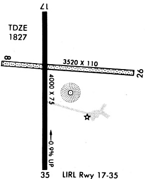
Runway Summary
| Runways: | 08/26 17/35 |
| Longest Runway: | 17/35 is 4605 ft (1404 m) long |
| Runways with an Instrument Approach: |
BBD Airport Runway Details
| Runway 08/26 | 3520 ft x 110 ft (1073 m x 34 m) | |
| Surface: | Turf - Fair condition - No special surface treatment | |
Runway 08 |
Runway 26 |
|
Elevation: |
1812.1 | 1823.1 |
Latitude: |
31-10-47.9695N | 31-10-45.9007N |
Longitude: |
099-19-43.0393W | 099-19-02.5904W |
|
Runway True Alignment: |
093 | 273 |
Glide Path Angle: |
0.0 degrees | 0.0 degrees |
Object at End: |
FENCE | FENCE |
Object Height: |
12 | 12 |
Distance from End: |
120 | 182 |
Object Centerline Offset: |
0 ft. left and right of centerline | 0 ft. left and right of centerline |
| Runway 17/35 | 4605 ft x 75 ft (1404 m x 23 m) | |
| Runway Length Source: | 3RD PARTY SURVEY as of 04/27/2007 | |
| Surface: | Turf - Fair condition - No special surface treatment | |
| Runway Edge Lights: | Medium Intensity | |
Runway Weight Bearing Capacity (in thousands of pounds) |
||
| Single Wheel Landing Gear: | 21.0 | |
Runway 17 |
Runway 35 |
|
Elevation: |
1826.2 | 1792.5 |
Latitude: |
31-11-07.0766N | 31-10-21.5090N |
Longitude: |
099-19-28.6068W | 099-19-28.7417W |
|
Runway True Alignment: |
180 | 000 |
Glide Path Angle: |
3.0 degrees | 3.0 degrees |
Traffic Pattern: |
Left | Left |
Runway Markings Type: |
Nonprecision Instrument | Nonprecision Instrument |
Runway Markings Condition: |
Good | Good |
Object at End: |
TREE | |
Object Height: |
28 | |
Distance from End: |
1178 | |
Object Centerline Offset: |
0 ft. left and right of centerline | 0 ft. left and right of centerline |
Visual Glide Slope Indicators: |
2-Light PAPI On Left Side Of Runway | 2-Light PAPI On Left Side Of Runway |
Threshold Crossing Height: |
40 | 48 |
Services
Airframe Repair: |
Major |
Powerplant Repair: |
Major |
Bottled Oxygen: |
None |
Bulk Oxygen: |
None |
Fuel Available: |
100LL, Jet A+ |
Landing Fees: |
No |
Parking: |
Hangars and tiedowns available |
Maps & Diagrams
BBD Sectional
Flight Planning
at skyvector.com
at skyvector.com