Location
Latitude: |
60-52-04.4000N (60.867889) |
Longitude: |
162-16-27.4000W (-162.274278) |
Elevation: |
19.4 feet MSL (6 m MSL) |
Magnetic Variation: |
9.6 E (as of April 2024 from WMM2020 model) |
Time Zone: |
UTC -9.0 (Standard Time) UTC -8.0 (Daylight Savings Time) |
From City: |
00 N.M. NE of Atmautluak, Alaska |
Found On: |
Bethel Chart |
FAA Region: |
AAL |
Contacts
Manager: |
Publicly owned: |
| JOSEPH LARAUX PO BOX 505 BETHEL, AK 99559 (907) 543-2498 |
ALASKA DOT&PF CENTRAL REGION PO BOX 196900 ANCHORAGE, AK 99519-6900 907-269-0760 |
Operations
Airport Status: |
Operational |
Facility Use: |
Public |
Type: |
Airport |
Activation Date: |
07/1977 |
Control tower: |
No |
Attendance (Months/Days/Hours): |
Months/Days/Hours Unattended |
Boundary ARTCC: |
ZAN (Anchorage) |
Responsible ARTCC: |
ZAN (Anchorage) |
Lighting Schedule: |
SEE RMK |
Segmented Circle Indicator: |
No |
Traffic Pattern Altitude (MSL): |
1019 feet (311 m) |
NOTAMs Facility: |
ENA |
NOTAM-D Service: |
Yes |
International Airport of Entry: |
No |
Customs Landing Rights: |
No |
Military Landing Rights: |
Yes |
Based Aircraft
Annual Operations (as of 12/31/2022)
| Total Operations: | 500 | |
| Air Taxi: | 500 | 100.0% |
Communications
| CTAF: | 122.900 |
Fixed Based Operators (FBOs) & Fuel
(Click on a business for detail)
Please help us keep this information up to date. This is a FREE SERVICE just like everything else on Airport Guide! If you see that a business needs to be added, modified, or deleted please fill out our Update Form.
To add, modify, or delete a business click here.
Please help us keep this information up to date. This is a FREE SERVICE just like everything else on Airport Guide! If you see that a business needs to be added, modified, or deleted please fill out our Update Form.
Area Code: 907 |
| Business Name | Frequency | Phone | Fuel Grade |
|---|
Flight Service Stations
| Primary | Alternate | |
| FSS on Field: | N | |
| FSS Name (ID): | Kenai(ENA) | |
| Frequency: | ||
| Toll Free Phone: | 1-866-864-1737 |
Instrument Procedures / Charts
Terminal Procedures are only available for airports in several countries with more being added all the time. If you are looking for a specific country's charts, please send an email to support(at)airportguide.com stating the country name. This will be used to prioritize the implementation.
Navigation Aids (Navaids) near ATT
| Dist (NM) | ID | Morse Code | Name | Type | Freq | True Hdg | Mag Hdg |
|---|---|---|---|---|---|---|---|
| 12.6 | OSE | _ _ _ . . . . | Oscarville | NDB | 251 | 111 | 101 |
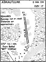
| 14.1 | BET | _ . . . . _ | Bethel | VORTAC | 114.10 | 110 | 100 |
| 77.1 | SMA | . . . _ _ . _ | St Marys | NDB | 230 | 338 | 329 |
| 88.6 | ANI | . _ _ . . . | Aniak | NDB | 359 | 59 | 49 |
Nearby Airports with Fuel
| Dist (NM) | Name (Airport IDs) | True Hdg | Mag Hdg | Fuel Grade |
|---|---|---|---|---|
| 13.9 | Bethel Airport (BET PABE BET) |
112 | 102 | 100, 100LL, Jet A, Jet A-1 |
| 68.0 | Quinhagak Airport (KWN PAQH AQH) |
169 | 159 | 100LL |
| 89.7 | Aniak Airport (ANI PANI ANI) |
60 | 49 | 100LL, Jet A |
Notices to Airmen (NOTAMS)
Remarks
| A110-1 | RWY COND UNMNT; RCMD VISUAL INSP BFR USE. |
| A110-11 | RWY, TWY & RAMP HAS 4-6 IN DIPS & RUTS. RWY SINKS & SLOPED E. |
| A110-8 | WX CAMERA AVBL ON INTERNET AT HTTPS://WEATHERCAMS.FAA.GOV |
| A110-9 | BIRDS INVOF RWY. |
| A43-15 | PAPI UNUSBL BYD 8 DEGS RIGHT OF CNTRLN. |
| A81-APT | ACTVT REIL RWY 15 & 33; PAPI RWY 15 & 33; MIRL RWY 15/33 - CTAF. |
Runways
Runway Summary
| Runways: | 15/33 |
| Longest Runway: | 15/33 is 3000 ft (914 m) long |
| Runways with an Instrument Approach: |
ATT Airport Runway Details
| Runway 15/33 | 3000 ft x 75 ft (914 m x 23 m) | |
| Runway Length Source: | 3RD PARTY SURVEY as of 07/02/2013 | |
| Surface: | Gravel - Excellent condition - No special surface treatment | |
| Runway Edge Lights: | Medium Intensity | |
Runway 15 |
Runway 33 |
|
Elevation: |
18.0 | 19.2 |
Latitude: |
60-52-18.7025N | 60-51-50.0018N |
Longitude: |
162-16-34.5677W | 162-16-20.2024W |
|
Runway True Alignment: |
166 | 346 |
Glide Path Angle: |
3.0 degrees | 3.0 degrees |
Traffic Pattern: |
Left | Left |
Object at End: |
BRUSH | BRUSH |
Object Height: |
4 | 6 |
Distance from End: |
52 | 0 |
Object Centerline Offset: |
90 ft. right of centerline | 107 ft. left of centerline |
Visual Glide Slope Indicators: |
4-Light PAPI On Left Side Of Runway | 4-Light PAPI On Left Side Of Runway |
REIL: |
Yes | Yes |
Threshold Crossing Height: |
25 | 24 |
Services
Airframe Repair: |
Minor |
Powerplant Repair: |
Minor |
Fuel Available: |
100LL, Jet A |
Landing Fees: |
No |
Parking: |
Tiedowns available |
Maps & Diagrams
ATT Sectional
Flight Planning
at skyvector.com
at skyvector.com