Location
Latitude: |
42-46-56.6900N (42.782414) |
Longitude: |
071-30-50.7400W (-71.514094) |
Elevation: |
200.4 feet MSL (61 m MSL) |
Magnetic Variation: |
14.1 W (as of April 2024 from WMM2020 model) |
Time Zone: |
UTC -5.0 (Standard Time) UTC -4.0 (Daylight Savings Time) |
From City: |
03 N.M. NW of Nashua, New Hampshire |
Found On: |
New York Chart |
FAA Region: |
ANE |
Contacts
Manager: |
Publicly owned: |
| CHRIS LYNCH 93 PERIMETER RD NASHUA, NH 03063 603-882-0661 |
NASHUA AIRPORT AUTHORITY 93 PERIMETER RD NASHUA, NH 03063 603-882-0661 |
Operations
Airport Status: |
Operational |
Facility Use: |
Public |
Type: |
Airport |
Activation Date: |
03/1947 |
Control tower: |
Yes |
Attendance (Months/Days/Hours): |
Months/Days/Hours ALL/ALL/0700-2100 |
Boundary ARTCC: |
ZBW (Boston) |
Responsible ARTCC: |
ZBW (Boston) |
Lighting Schedule: |
SEE RMK |
Traffic Pattern Altitude (MSL): |
1200 feet (366 m) |
NOTAMs Facility: |
ASH |
NOTAM-D Service: |
Yes |
International Airport of Entry: |
No |
Customs Landing Rights: |
No |
Military Landing Rights: |
Yes |
Civil/Military Joint Use: |
No |
Based Aircraft
| Single Engine: | 162 |
| Multi Engine: | 25 |
| Jet Engine: | 10 |
| GA Helicopters: | 12 |
Annual Operations (as of 10/01/2022)
| Total Operations: | 58726 | |
| Air Taxi: | 200 | 0.3% |
| GA Local: | 30000 | 51.1% |
| GA Itinerant: | 28500 | 48.5% |
| Military Aircraft: | 26 | 0.0% |
Communications
| CTAF: | 133.200 |
| Tower: | NASHUA 133.2 Hrs: 0700-2100 |
| Clearance Del.: | 121.8 121.8 ;WHEN ASH TWR CLSD 121.8 ;WHEN ASH TWR CLSD 121.8 ;WHEN ASH TWR CLSD 121.8 ;WHEN ASH TWR CLSD |
| Ground: | 121.8 |
| Approach: | BOSTON |
| Departure: | BOSTON |
| ATIS: | 125.1 Hrs: 24 |
| AWOS-3PT: | 125.1 (603-578-0473) |
- ATCT LEASED TO CITY OF NASHUA & OPRD BY MID-WEST ATC SVCS INC.
Fixed Based Operators (FBOs) & Fuel
(Click on a business for detail)
Please help us keep this information up to date. This is a FREE SERVICE just like everything else on Airport Guide! If you see that a business needs to be added, modified, or deleted please fill out our Update Form.
click here.
Please help us keep this information up to date. This is a FREE SERVICE just like everything else on Airport Guide! If you see that a business needs to be added, modified, or deleted please fill out our Update Form.
Area Code: 603 |
Flight Service Stations
| Primary | Alternate | |
| FSS on Field: | N | |
| FSS Name (ID): | Bangor(BGR) | |
| Frequency: | ||
| Toll Free Phone: | 1-800-WX-BRIEF |
Instrument Procedures / Charts
FAA Terminal Procedures valid from 0901Z 03/21/24 to 0901Z 04/18/24.
There are various types of charts available for an airport. They are listed in the Page Type column. Here is a legend for those types:
APD - Airport Diagram
DP - Departure Procedure Charts
HOT - Hot Spots
IAP - Instrument Approach Procedure Charts
MIN - Minimums
STAR - Standard Terminal Arrival Charts
| Page Type | Page Name | Volume | Action Since Last Cycle |
|---|---|---|---|
| APD | AIRPORT DIAGRAM | NE-1 | |
| IAP | ILS OR LOC RWY 14 | NE-1 | |
| IAP | RNAV (GPS) RWY 14 | NE-1 | |
| IAP | RNAV (GPS) RWY 32 | NE-1 | |
| MIN | ALTERNATE MINIMUMS | NE-1 | |
| MIN | TAKEOFF MINIMUMS | NE-1 |
Terminal Procedures are only available for airports in several countries with more being added all the time. If you are looking for a specific country's charts, please send an email to support(at)airportguide.com stating the country name. This will be used to prioritize the implementation.
Navigation Aids (Navaids) near ASH
| Dist (NM) | ID | Morse Code | Name | Type | Freq | True Hdg | Mag Hdg |
|---|---|---|---|---|---|---|---|
| 4.6 | AS | . _ . . . | Chern | NDB | 359 | 302 | 316 |
| 4.9 | MJ | _ _ . _ _ _ | Fitzy | NDB | 209 | 352 | 366 |
| 8.2 | MHT | _ _ . . . . _ | Manchester | VOR-DME | 114.40 | 50 | 64 |
| 16.2 | LW | . _ . . . _ _ | Haget | NDB | 402 | 120 | 134 |
| 17.5 | FIT | . . _ . . . _ | Fitchburg | NDB | 365 | 217 | 231 |
| 18.6 | LWM | . _ . . . _ _ _ _ | Lawrence | DME | 112.5 | 97 | 111 |
| 19.0 | BE | _ . . . . | Bedds | NDB | 332 | 163 | 177 |
| 20.4 | CO | _ . _ . _ _ _ | Epsom | NDB | 216 | 7 | 21 |
| 21.5 | BED | _ . . . . _ . . | Bedford | VOT | 110.00 | 152 | 166 |
| 24.6 | SKR | . . . _ . _ . _ . | Shaker Hill | NDB | 251 | 142 | 156 |
| 26.4 | CON | _ . _ . _ _ _ _ . | Concord | VOR-DME | 112.90 | 354 | 368 |
| 27.2 | BVY | _ . . . . . . _ _ . _ _ | Beverly | FAN MARKER | 112 | 126 | |
| 27.9 | GDM | _ _ . _ . . _ _ | Gardner | VOR-DME | 110.60 | 239 | 253 |
| 31.4 | LQ | . _ . . _ _ . _ | Lyndy | NDB | 382 | 128 | 142 |
| 34.3 | EEN | . . _ . | Keene | DME | 109.4 | 271 | 285 |
| 34.5 | BOS | _ . . . _ _ _ . . . | Boston | VOR-DME | 112.70 | 137 | 151 |
| 34.5 | BOS | _ . . . _ _ _ . . . | Boston | VOT | 111.00 | 137 | 151 |
| 34.7 | ORH | _ _ _ . _ . . . . . | Worcester | VOT | 108.20 | 206 | 220 |
| 35.0 | PSM | . _ _ . . . . _ _ | Pease | DME | 116.5 | 58 | 72 |
| 36.4 | ORE | _ _ _ . _ . . | Orange | NDB | 205 | 249 | 263 |
Nearby Airports with Fuel
Notices to Airmen (NOTAMS)
Remarks
| A110-1 | ARPT HAS VOLUNTARY NOISE ABATEMENT PROCS. CTC AMGR FOR DETAILS. |
| A110-2 | MIGRATORY BIRDS & WILDLIFE ON & INVOF ARPT. |
| A110-3 | RAMP BTN TWY D & TWY E CLSD TO ACFT WITH WINGSPAN GTR THAN 48 FT UNLESS AUZD BY ATCT. |
| A24 | FOR ACFT OVR 12500 LBS, FEE PER 1000 LBS. |
| A56-14 | TREES LCTD ALG RAIL LN N OF RWY. |
| A57-32 | APCH SLOPE 44:1 TO DTHR. |
| A81-APT | WHEN TWR CLSD ACTVT MALSR RWY 14; REIL RWY 32; PAPI RWY 14; HIRL RWY 14/32 - CTAF. |
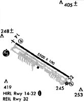
Runways
Runway Summary
| Runways: | 14/32 |
| Longest Runway: | 14/32 is 6000 ft (1829 m) long |
| Runways with an Instrument Approach: | 14 |
ASH Airport Runway Details
| Runway 14/32 | 6000 ft x 100 ft (1829 m x 30 m) | |
| Runway Length Source: | STATE as of 11/14/2012 | |
| Surface: | Asphalt - Excellent condition - Saw-cut or plastic grooved | |
| Runway Edge Lights: | High Intensity | |
Runway Weight Bearing Capacity (in thousands of pounds) |
||
| Single Wheel Landing Gear: | 62.0 | |
| Dual Wheel Landing Gear: | 80.0 | |
| Dual Tandem Wheel Landing Gear: | 133.0 | |
Runway 14 |
Runway 32 |
|
Elevation: |
200.4 | 192.0 |
Latitude: |
42-47-12.6982N | 42-46-40.6791N |
Longitude: |
071-31-24.5987W | 071-30-16.8912W |
|
Runway True Alignment: |
123 | 303 |
ILS Type: |
ILS | |
Glide Path Angle: |
3.0 degrees | 3.0 degrees |
Traffic Pattern: |
Left | Left |
Runway Markings Type: |
Precision Instrument | Nonprecision Instrument |
Runway Markings Condition: |
Good | Good |
Object at End: |
TREE | TREE |
Object Height: |
65 | 61 |
Distance from End: |
1050 | 1337 |
Object Centerline Offset: |
606 ft. left of centerline | 358 ft. left of centerline |
Visual Glide Slope Indicators: |
4-Light PAPI On Right Side Of Runway | 4-Light PAPI On Left Side Of Runway |
Approach Light System: |
1,400 Foot Medium Intensity Approach Lighting System With Runway Alignment Indicator Lights | |
REIL: |
Yes | |
Threshold Crossing Height: |
45 | 45 |
Threshold Elevation: |
191.1 | |
Displaced Threshold: |
350 | |
Threshold Latitude: |
42-46-42.5472N | |
Threshold Longitude: |
071-30-20.8402W | |
Declared Distances |
||
Take Off Run Avbl. (TORA): |
6000 | 6000 |
Take Off Distance Avbl. (TODA): |
6000 | 6000 |
Actual Stop Dist. Avbl. (ASDA): |
5650 | 6000 |
Landing Dist. Avbl. (LDA): |
5650 | 5650 |
Services
Airframe Repair: |
Major |
Powerplant Repair: |
Major |
Bottled Oxygen: |
None |
Bulk Oxygen: |
None |
Fuel Available: |
100LL |
Landing Fees: |
No |
Parking: |
Tiedowns available |
Maps & Diagrams
ASH Sectional
Flight Planning
at skyvector.com
at skyvector.com