Location
Latitude: |
45-55-40.5000N (45.927917) |
Longitude: |
089-43-51.4000W (-89.730944) |
Elevation: |
1629.5 feet MSL (497 m MSL) |
Magnetic Variation: |
3 W (as of April 2024 from WMM2020 model) |
Time Zone: |
UTC -6.0 (Standard Time) UTC -5.0 (Daylight Savings Time) |
From City: |
03 N.M. NW of Minocqua-Woodruff, Wisconsin |
Found On: |
Green Bay Chart |
FAA Region: |
AGL |
Contacts
Manager: |
Publicly owned: |
| JON SCHMITZ 1545 N. FARMING RD WOODRUFF, WI 54568 (715) 356-3891 |
LAKELAND AIRPORT COMMISSION 1545 N. FARMING RD. WOODRUFF, WI 54568 (715) 356-4340 |
Operations
Airport Status: |
Operational |
Facility Use: |
Public |
Type: |
Airport |
Activation Date: |
12/1945 |
Control tower: |
No |
Attendance (Months/Days/Hours): |
Months/Days/Hours OCT-MAY/ALL/0800-1700 |
Boundary ARTCC: |
ZMP (Minneapolis) |
Responsible ARTCC: |
ZMP (Minneapolis) |
Lighting Schedule: |
SEE RMK |
Segmented Circle Indicator: |
No |
Traffic Pattern Altitude (MSL): |
2630 feet (802 m) |
NOTAMs Facility: |
ARV |
NOTAM-D Service: |
Yes |
International Airport of Entry: |
No |
Customs Landing Rights: |
No |
Military Landing Rights: |
Yes |
Civil/Military Joint Use: |
No |
Based Aircraft
| Single Engine: | 32 |
| Multi Engine: | 3 |
| Jet Engine: | 1 |
Annual Operations (as of 08/10/2023)
| Total Operations: | 27190 | |
| Air Taxi: | 3180 | 11.7% |
| GA Local: | 9000 | 33.1% |
| GA Itinerant: | 15000 | 55.2% |
| Military Aircraft: | 10 | 0.0% |
Communications
| CTAF: | 122.700 |
| Unicom: | 122.700 |
| AWOS-3: | 121.125 (715-356-2417) |
- APCH/DEP SVC PRVDD BY MINNEAPOLIS ARTCC ON FREQS 133.65/281.5 (RHINELANDER RCAG).
Fixed Based Operators (FBOs) & Fuel
(Click on a business for detail)
Please help us keep this information up to date. This is a FREE SERVICE just like everything else on Airport Guide! If you see that a business needs to be added, modified, or deleted please fill out our Update Form.
To add, modify, or delete a business click here.
Please help us keep this information up to date. This is a FREE SERVICE just like everything else on Airport Guide! If you see that a business needs to be added, modified, or deleted please fill out our Update Form.
Area Code: 715 |
| Business Name | Frequency | Phone | Fuel Grade |
|---|---|---|---|
| Lakeland Aviation Co
Update FBO info |
122.75 | 356-3891 | 100LL, Jet A |
Flight Service Stations
| Primary | Alternate | |
| FSS on Field: | N | |
| FSS Name (ID): | Green Bay(GRB) | |
| Frequency: | ||
| Toll Free Phone: | 1-800-WX-BRIEF |
Instrument Procedures / Charts
FAA Terminal Procedures valid from 0901Z 03/21/24 to 0901Z 04/18/24.
There are various types of charts available for an airport. They are listed in the Page Type column. Here is a legend for those types:
APD - Airport Diagram
DP - Departure Procedure Charts
HOT - Hot Spots
IAP - Instrument Approach Procedure Charts
MIN - Minimums
STAR - Standard Terminal Arrival Charts
| Page Type | Page Name | Volume | Action Since Last Cycle |
|---|---|---|---|
| IAP | RNAV (GPS) RWY 18 | EC-3 | |
| IAP | RNAV (GPS) RWY 28 | EC-3 | |
| IAP | RNAV (GPS) RWY 36 | EC-3 | |
| MIN | ALTERNATE MINIMUMS | EC-3 | |
| MIN | TAKEOFF MINIMUMS | EC-3 |
Terminal Procedures are only available for airports in several countries with more being added all the time. If you are looking for a specific country's charts, please send an email to support(at)airportguide.com stating the country name. This will be used to prioritize the implementation.
Navigation Aids (Navaids) near ARV
| Dist (NM) | ID | Morse Code | Name | Type | Freq | True Hdg | Mag Hdg |
|---|---|---|---|---|---|---|---|
| 0.1 | ARV | . _ . _ . . . . _ | Arbor Vitae | NDB | 221 | 123 | 126 |
| 5.6 | DO | _ . . _ _ _ | Dougy | NDB | 236 | 179 | 182 |
| 12.7 | BDJ | _ . . . _ . . . _ _ _ | Boulder Junction | NDB | 206 | 14 | 17 |
| 18.6 | RH | . _ . . . . . | Arsha | NDB | 272 | 165 | 168 |
| 21.0 | RHI | . _ . . . . . . . | Rhinelander | VOR-DME | 109.20 | 146 | 149 |
| 25.4 | LNL | . _ . . _ . . _ . . | Land O Lakes | NDB | 396 | 58 | 61 |
| 28.7 | RXW | . _ . _ . . _ . _ _ | Watersmeet | NDB | 407 | 40 | 43 |
| 29.1 | PKF | . _ _ . _ . _ . . _ . | Park Falls | NDB | 371 | 273 | 276 |
| 31.5 | PBH | . _ _ . _ . . . . . . . | Phillips | NDB | 263 | 244 | 247 |
| 39.8 | IWD | . . . _ _ _ . . | Ironwood | VOR-DME | 108.80 | 335 | 338 |
| 43.8 | RRL | . _ . . _ . . _ . . | Merrill | NDB | 257 | 178 | 181 |
| 53.0 | AIG | . _ . . _ _ . | Antigo | NDB | 347 | 150 | 153 |
| 55.0 | MDZ | _ _ _ . . _ _ . . | Medford | NDB | 335 | 206 | 209 |
| 57.4 | OGM | _ _ _ _ _ . _ _ | Ontonagon | NDB | 375 | 15 | 18 |
| 59.0 | RCX | . _ . _ . _ . _ . . _ | Rusk County | NDB | 356 | 244 | 246 |
| 60.2 | FZK | . . _ . _ _ . . _ . _ | Wausau | NDB | 243 | 175 | 178 |
| 61.8 | ASX | . _ . . . _ . . _ | Ashland | VOR-DME | 110.20 | 307 | 310 |
| 65.2 | AUW | . _ . . _ . _ _ | Wausau | VOR-DME | 111.60 | 174 | 177 |
| 68.0 | IMT | . . _ _ _ | Iron Mountain | VOR-DME | 111.20 | 95 | 99 |
| 71.7 | HYR | . . . . _ . _ _ . _ . | Hayward | DME | 113.4 | 274 | 276 |
Nearby Airports with Fuel
Notices to Airmen (NOTAMS)
Remarks
| A11 | TOWNS OF ARBOR VITAE, LAC DU FLAMBEAU, MINOCQUA, WOODRUFF. |
| A110-1 | SANDHILL CRANES ON & INVOF ARPT. |
| A110-2 | FOR CD IF UNA TO CTC ON FSS FREQ, CTC MINNEAPOLIS ARTCC AT 651-463-5588. |
| A15 | EMAIL ADDRESS: LAKELANDAIRPORT@FRONTIER.COM (ALL LOWER CASE) |
| A17 | FOR ATTENDANT OTHER HRS CALL 715-490-4418. |
| A40-18/36 | NSTD HIRL; NSTD THLD LGTS MALS TYPE THLD LGT BAR IN ADDITION TO STD LGTG. |
| A81-APT | HIRL RWY 18/36 PRESET TO LOW SS-SR; INCR INTST AND ACTVT MALSR RWY 36; REIL RWY 18 & 28; VASI RWY 18 & 36; PAPI RWY 28; MIRL RWY 10/28 - CTAF. |
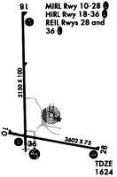
Runways
Runway Summary
| Runways: | 10/28 18/36 |
| Longest Runway: | 18/36 is 5150 ft (1570 m) long |
| Runways with an Instrument Approach: | 36 |
ARV Airport Runway Details
| Runway 10/28 | 3602 ft x 75 ft (1098 m x 23 m) | |
| Runway Length Source: | 3RD PARTY SURVEY as of 08/23/2011 | |
| Surface: | Asphalt - Good condition - No special surface treatment | |
| Runway Edge Lights: | Medium Intensity | |
Runway Weight Bearing Capacity (in thousands of pounds) |
||
| Single Wheel Landing Gear: | 35.0 | |
Runway 10 |
Runway 28 |
|
Elevation: |
1622.5 | 1622.8 |
Latitude: |
45-55-29.6831N | 45-55-23.1816N |
Longitude: |
089-44-06.7045W | 089-43-16.6080W |
|
Runway True Alignment: |
101 | 281 |
Glide Path Angle: |
0.0 degrees | 3.0 degrees |
Traffic Pattern: |
Left | Left |
Runway Markings Type: |
Nonprecision Instrument | Nonprecision Instrument |
Runway Markings Condition: |
Good | Good |
Object at End: |
TREES | |
Object Height: |
71 | |
Distance from End: |
1000 | |
Object Centerline Offset: |
190 ft. right of centerline | |
Visual Glide Slope Indicators: |
2-Light PAPI On Left Side Of Runway | |
REIL: |
No | Yes |
Touchdown Lights: |
No | No |
Centerline Lights: |
No | No |
Threshold Crossing Height: |
37 |
| Runway 18/36 | 5150 ft x 100 ft (1570 m x 30 m) | |
| Runway Length Source: | 3RD PARTY SURVEY as of 08/23/2011 | |
| Surface: | Asphalt - Good condition - No special surface treatment | |
| Runway Edge Lights: | High Intensity | |
Runway Weight Bearing Capacity (in thousands of pounds) |
||
| Single Wheel Landing Gear: | 90.0 | |
| Dual Wheel Landing Gear: | 150.0 | |
Runway 18 |
Runway 36 |
|
Elevation: |
1629.5 | 1623.6 |
Latitude: |
45-56-15.8095N | 45-55-24.9825N |
Longitude: |
089-43-58.9048W | 089-43-57.5340W |
|
Runway True Alignment: |
179 | 359 |
ILS Type: |
LOCALIZER | |
Glide Path Angle: |
3.0 degrees | 3.0 degrees |
Traffic Pattern: |
Left | Left |
Runway Markings Type: |
Nonprecision Instrument | Nonprecision Instrument |
Runway Markings Condition: |
Fair | Fair |
Object at End: |
TREES | |
Object Height: |
100 | |
Distance from End: |
3150 | |
Object Centerline Offset: |
190 ft. right of centerline | |
Visual Glide Slope Indicators: |
4-Box VASI On Left Side Of Runway | 4-Box VASI On Left Side Of Runway |
Approach Light System: |
1,400 Foot Medium Intensity Approach Lighting System With Runway Alignment Indicator Lights | |
REIL: |
Yes | No |
Touchdown Lights: |
No | No |
Centerline Lights: |
No | No |
Threshold Crossing Height: |
44 | 45 |
Services
Airframe Repair: |
Minor |
Powerplant Repair: |
Minor |
Bottled Oxygen: |
None |
Bulk Oxygen: |
None |
Fuel Available: |
100LL |
Landing Fees: |
No |
Parking: |
Tiedowns available |
Maps & Diagrams
ARV Sectional
Flight Planning
at skyvector.com
at skyvector.com