Location
Latitude: |
43-01-15.9464N (43.021096) |
Longitude: |
078-28-57.4795W (-78.482633) |
Elevation: |
839.7 feet MSL (256 m MSL) |
Magnetic Variation: |
10.7 W (as of April 2024 from WMM2020 model) |
Time Zone: |
UTC -5.0 (Standard Time) UTC -4.0 (Daylight Savings Time) |
From City: |
01 N.M. E of Akron, New York |
Found On: |
Detroit Chart |
FAA Region: |
AEA |
Contacts
Manager: |
Privately owned: |
| ALLISON FREY BOX 126, JOHN ST. AKRON, NY 14001 716-542-4607 |
CHRISTIAN AIRMEN INC. PO BOX 126 AKRON, NY 14001 716-542-4607 |
Operations
Airport Status: |
Operational |
Facility Use: |
Public |
Type: |
Airport |
Activation Date: |
02/1961 |
Control tower: |
No |
Attendance (Months/Days/Hours): |
Months/Days/Hours JAN-DEC/MON-SAT/0830-1630 LOCAL |
Boundary ARTCC: |
ZOB (Cleveland) |
Responsible ARTCC: |
ZOB (Cleveland) |
Lighting Schedule: |
SEE RMK |
Segmented Circle Indicator: |
No |
Traffic Pattern Altitude (MSL): |
1840 feet (561 m) |
NOTAMs Facility: |
BUF |
NOTAM-D Service: |
Yes |
International Airport of Entry: |
No |
Customs Landing Rights: |
No |
Military Landing Rights: |
No |
Civil/Military Joint Use: |
No |
Based Aircraft
| Single Engine: | 59 |
| Multi Engine: | 5 |
Annual Operations (as of 05/23/2018)
| Total Operations: | 50900 | |
| Air Taxi: | 900 | 1.8% |
| GA Local: | 40000 | 78.6% |
| GA Itinerant: | 10000 | 19.6% |
Communications
| CTAF: | 122.725 |
| Unicom: | 122.725 |
| Approach: | BUFFALO 126.15 126.15 |
| Departure: | BUFFALO 126.15 126.15 |
Fixed Based Operators (FBOs) & Fuel
(Click on a business for detail)
Please help us keep this information up to date. This is a FREE SERVICE just like everything else on Airport Guide! If you see that a business needs to be added, modified, or deleted please fill out our Update Form.
To add, modify, or delete a business click here.
Please help us keep this information up to date. This is a FREE SERVICE just like everything else on Airport Guide! If you see that a business needs to be added, modified, or deleted please fill out our Update Form.
Area Code: 716 |
| Business Name | Frequency | Phone | Fuel Grade |
|---|---|---|---|
| Christian Airmen, Inc.
Update FBO info |
Unicom 122.8 | 542-4607 | 80, 100LL |

|
Air Bp | 80/87 - 2.99 USD per gallon on 9/23/01 |
Trucks |
|
|
Air Bp | 100LL - 2.49 USD per gallon on 9/23/01 |
Trucks |
Flight Service Stations
| Primary | Alternate | |
| FSS on Field: | N | |
| FSS Name (ID): | Buffalo(BUF) | |
| Frequency: | ||
| Toll Free Phone: | 1-800-WX-BRIEF |
Instrument Procedures / Charts
FAA Terminal Procedures valid from 0901Z 03/21/24 to 0901Z 04/18/24.
There are various types of charts available for an airport. They are listed in the Page Type column. Here is a legend for those types:
APD - Airport Diagram
DP - Departure Procedure Charts
HOT - Hot Spots
IAP - Instrument Approach Procedure Charts
MIN - Minimums
STAR - Standard Terminal Arrival Charts
| Page Type | Page Name | Volume | Action Since Last Cycle |
|---|---|---|---|
| IAP | RNAV (GPS) RWY 07 | NE-2 | |
| IAP | RNAV (GPS) RWY 25 | NE-2 | |
| MIN | TAKEOFF MINIMUMS | NE-2 |
Terminal Procedures are only available for airports in several countries with more being added all the time. If you are looking for a specific country's charts, please send an email to support(at)airportguide.com stating the country name. This will be used to prioritize the implementation.
Navigation Aids (Navaids) near 9G3
| Dist (NM) | ID | Morse Code | Name | Type | Freq | True Hdg | Mag Hdg |
|---|---|---|---|---|---|---|---|
| 7.5 | BU | _ . . . . . _ | Klump | NDB | 231 | 260 | 271 |
| 9.1 | BUF | _ . . . . . _ . . _ . | Buffalo | DME | 116.4 | 232 | 243 |
| 12.1 | BUF | _ . . . . . _ . . _ . | Buffalo | VOT | 109.00 | 246 | 257 |
| 16.5 | IA | . . . _ | Kathi | NDB | 329 | 288 | 299 |
| 17.1 | GB | _ _ . _ . . . | Plazz | NDB | 204 | 239 | 250 |
| 21.6 | IAG | . . . _ _ _ . | Niagara Falls | TACAN | 111.00 | 284 | 295 |
| 31.3 | AVN | . _ . . . _ _ . | Avon | NDB | 344 | 90 | 101 |
| 34.7 | SN | St. Catharines | NDB | 408 | 282 | 292 | |
| 34.8 | GEE | _ _ . . . | Geneseo | VOR-DME | 108.20 | 108 | 119 |
| 36.0 | ROC | . _ . _ _ _ _ . _ . | Rochester | VOR-DME | 110.00 | 80 | 91 |
| 44.7 | LYS | . _ . . _ . _ _ . . . | Olean | NDB | 360 | 171 | 182 |
| 47.2 | DKK | _ . . _ . _ _ . _ | Dunkirk | DME | 116.2 | 227 | 237 |
| 53.0 | TZ | Gibraltar Point | NDB | 257 | 312 | 322 | |
| 54.1 | ITZ | City Centre | DME | 110.15 | 312 | 322 | |
| 56.6 | IOO | Oshawa | DME | 111.35 | 342 | 353 | |
| 57.0 | OO | Oshawa | NDB | 391 | 341 | 352 | |
| 57.4 | JHW | . _ _ _ . . . . . _ _ | Jamestown | VOR-DME | 114.70 | 209 | 219 |
| 57.9 | ZHM | Binbrook | NDB | 266 | 277 | 287 | |
| 58.7 | ZYZ | Queensway | NDB | 368 | 308 | 318 | |
| 59.8 | ELZ | . . _ . . _ _ . . | Wellsville | DME | 115.85 | 158 | 169 |
Nearby Airports with Fuel
Notices to Airmen (NOTAMS)
Remarks
| A110-2 | PARL TWY LGTD AND 35 FT WIDE. |
| A110-6 | RWY 25 NOISE ABATEMENT - MNTN RWY HDG TIL 3/4 MI BYD DEP END RWY 25 BFR TURNING. |
| A110-7 | FOR CD CTC CLEVELAND ARTCC AT 440-774-0490. |
| A17 | HRS SUBJECT TO CHANGE CTC AMGR. |
| A30-11/29 | CLSD INDEFLY. |
| A30A-07 | +40 FT TREES 172 FT R 263 FT FM RWY; +49 FT TREES 200-230 FT L 208-332 FT FM RWY; +34 FT TREES PENTRATE TRSN SFC ON R SIDE OF RWY 310 FT FM CNTLN 0-310 FT DOWN RWY. |
| A30A-25 | +43 FT TREES 135 FT L 454 FT FM RWY; +15 FT RD 300 FT FM RWY OB. |
| A43-07 | UNUSBL BYD 7 DEGS RIGHT OF CNTRLN. |
| A58-07 | +8 FT FENCE AT 195 FT OUT, 165 FT RT. |
| A58-25 | +8 FT FENCE 198 FT OUT AND 213 FT LEFT. |
| A70-FUEL-10 | 0LL 100LL FUEL AVBL 24 HRS. |
| A81-APT | ACTVT PAPI RWY 07 & 25 - CTAF. SS-SR, ACTVT REIL RWY 25; MIRL RWY 07/25 - CTAF. |
Runways
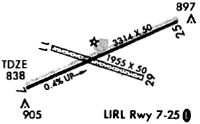
Runway Summary
| Runways: | 07/25 11/29 |
| Longest Runway: | 07/25 is 3268 ft (996 m) long |
| Runways with an Instrument Approach: |
9G3 Airport Runway Details
| Runway 07/25 | 3268 ft x 75 ft (996 m x 23 m) | |
| Runway Length Source: | 3RD PARTY SURVEY as of 11/11/2011 | |
| Surface: | Asphalt - Fair condition - No special surface treatment | |
| Runway Edge Lights: | Medium Intensity | |
Runway Weight Bearing Capacity (in thousands of pounds) |
||
| Single Wheel Landing Gear: | 8.0 | |
Runway 07 |
Runway 25 |
|
Elevation: |
829.8 | 839.7 |
Latitude: |
43-01-07.7857N | 43-01-24.1071N |
Longitude: |
078-29-16.4535W | 078-28-38.5055W |
|
Runway True Alignment: |
060 | 240 |
Glide Path Angle: |
4.0 degrees | 4.0 degrees |
Traffic Pattern: |
Left | Left |
Runway Markings Type: |
Nonprecision Instrument | Nonprecision Instrument |
Runway Markings Condition: |
Fair | Fair |
Object at End: |
TREES | TREES |
Object Height: |
36 | 26 |
Distance from End: |
214 | 240 |
Object Centerline Offset: |
214 ft. right of centerline | 240 ft. right of centerline |
Visual Glide Slope Indicators: |
2-Light PAPI On Left Side Of Runway | 2-Light PAPI On Left Side Of Runway |
REIL: |
No | Yes |
Touchdown Lights: |
No | No |
Centerline Lights: |
No | No |
Threshold Crossing Height: |
54 | 55 |
| Runway 11/29 | 1955 ft x 50 ft (596 m x 15 m) | |
| Surface: | Asphalt - Fair condition - No special surface treatment | |
Runway 11 |
Runway 29 |
|
|
Runway True Alignment: |
109 | 289 |
Glide Path Angle: |
0.0 degrees | 0.0 degrees |
Object at End: |
TREES | TREES |
Object Height: |
25 | 50 |
Distance from End: |
0 | 0 |
Object Centerline Offset: |
214 ft. right of centerline | 240 ft. right of centerline |
Services
Airframe Repair: |
Major |
Powerplant Repair: |
Major |
Bottled Oxygen: |
None |
Bulk Oxygen: |
None |
Fuel Available: |
100LL |
Landing Fees: |
No |
Parking: |
Tiedowns available |
Maps & Diagrams
9G3 Sectional
Flight Planning
at skyvector.com
at skyvector.com