Location
Latitude: |
36-41-50.7000N (36.697417) |
Longitude: |
093-54-01.9000W (-93.900528) |
Elevation: |
1482.6 feet MSL (452 m MSL) |
Magnetic Variation: |
0.8 E (as of April 2024 from WMM2020 model) |
Time Zone: |
UTC -6.0 (Standard Time) UTC -5.0 (Daylight Savings Time) |
From City: |
02 N.M. NW of Cassville, Missouri |
Found On: |
Kansas City Chart |
FAA Region: |
ACE |
Contacts
Manager: |
Publicly owned: |
| JUSTIN HENSON 300 S MAIN CASSVILLE, MO 65625 417-847-4441 |
CITY OF CASSVILLE 300 MAIN ST CASSVILLE, MO 65625 417-847-4441 |
Operations
Airport Status: |
Operational |
Facility Use: |
Public |
Type: |
Airport |
Control tower: |
No |
Attendance (Months/Days/Hours): |
Months/Days/Hours Unattended |
Boundary ARTCC: |
ZKC (Kansas City) |
Responsible ARTCC: |
ZKC (Kansas City) |
Lighting Schedule: |
SEE RMK |
Segmented Circle Indicator: |
Yes |
Traffic Pattern Altitude (MSL): |
2483 feet (757 m) |
NOTAMs Facility: |
COU |
NOTAM-D Service: |
Yes |
International Airport of Entry: |
No |
Customs Landing Rights: |
No |
Military Landing Rights: |
Yes |
Based Aircraft
| Single Engine: | 12 |
Annual Operations (as of 12/31/2021)
| Total Operations: | 3600 | |
| Air Taxi: | 50 | 1.4% |
| GA Local: | 1076 | 29.9% |
| GA Itinerant: | 2474 | 68.7% |
Communications
| CTAF: | 122.900 |
| Approach: | SPRINGFIELD 124.95 124.95 |
| Departure: | SPRINGFIELD 124.95 124.95 |
Fixed Based Operators (FBOs) & Fuel
(Click on a business for detail)
Please help us keep this information up to date. This is a FREE SERVICE just like everything else on Airport Guide! If you see that a business needs to be added, modified, or deleted please fill out our Update Form.
To add, modify, or delete a business click here.
Please help us keep this information up to date. This is a FREE SERVICE just like everything else on Airport Guide! If you see that a business needs to be added, modified, or deleted please fill out our Update Form.
Area Code: 417 |
| Business Name | Frequency | Phone | Fuel Grade |
|---|---|---|---|
| Dale's Aircraft Service
Update FBO info |
Unicom 122.9 | 847-4647 | 100LL, MOGAS |
Flight Service Stations
| Primary | Alternate | |
| FSS on Field: | N | |
| FSS Name (ID): | Columbia(COU) | |
| Frequency: | ||
| Toll Free Phone: | 1-800-WX-BRIEF |
Instrument Procedures / Charts
FAA Terminal Procedures valid from 0901Z 03/21/24 to 0901Z 04/18/24.
There are various types of charts available for an airport. They are listed in the Page Type column. Here is a legend for those types:
APD - Airport Diagram
DP - Departure Procedure Charts
HOT - Hot Spots
IAP - Instrument Approach Procedure Charts
MIN - Minimums
STAR - Standard Terminal Arrival Charts
| Page Type | Page Name | Volume | Action Since Last Cycle |
|---|---|---|---|
| IAP | RNAV (GPS) RWY 09 | NC-3 | |
| IAP | RNAV (GPS) RWY 27 | NC-3 | |
| MIN | TAKEOFF MINIMUMS | NC-3 |
Terminal Procedures are only available for airports in several countries with more being added all the time. If you are looking for a specific country's charts, please send an email to support(at)airportguide.com stating the country name. This will be used to prioritize the implementation.
Navigation Aids (Navaids) near 94K
| Dist (NM) | ID | Morse Code | Name | Type | Freq | True Hdg | Mag Hdg |
|---|---|---|---|---|---|---|---|
| 16.3 | RO | . _ . _ _ _ | Rogrs | NDB | 263 | 209 | 208 |
| 27.2 | EOS | . _ _ _ . . . | Neosho | DME | 117.3 | 288 | 287 |
| 29.1 | RZC | . _ . _ _ . . _ . _ . | Razorback | VORTAC | 116.40 | 201 | 200 |
| 40.2 | HRO | . . . . . _ . _ _ _ | Harrison | VOR-DME | 112.50 | 124 | 123 |
| 41.7 | SLG | . . . . _ . . _ _ . | Siloam Springs | NDB | 284 | 223 | 222 |
| 41.8 | DAK | _ . . . _ _ . _ | Drake | DME | 115.25 | 200 | 199 |
| 43.8 | JL | . _ _ _ . _ . . | Lunns | NDB | 344 | 314 | 313 |
| 46.9 | HR | . . . . . _ . | Bakky | NDB | 395 | 130 | 129 |
| 47.9 | SGF | . . . _ _ . . . _ . | Springfield | VORTAC | 116.90 | 34 | 33 |
| 51.3 | LLU | . _ . . . _ . . . . _ | Spring River | NDB | 356 | 337 | 336 |
| 52.9 | DGD | _ . . _ _ . _ . . | Dogwood | VORTAC | 109.40 | 67 | 67 |
| 59.7 | PTS | . _ _ . _ . . . | Pittsburg | NDB | 365 | 318 | 317 |
| 68.3 | OSW | _ _ _ . . . . _ _ | Oswego | DME | 117.6 | 294 | 293 |
| 70.7 | TQH | _ _ _ . _ . . . . | Tahlequah | NDB | 215 | 229 | 228 |
| 73.5 | FLP | . . _ . . _ . . . _ _ . | Flippin | DME | 116.05 | 108 | 108 |
| 77.2 | CZE | _ . _ . _ _ . . . | Clarksville | NDB | 201 | 162 | 161 |
| 77.8 | FSK | . . _ . . . . _ . _ | Fort Scott | NDB | 379 | 328 | 327 |
| 79.3 | IEB | . . . _ . . . | Lebanon | NDB | 414 | 48 | 48 |
| 80.6 | FSM | . . _ . . . . _ _ | Fort Smith | VORTAC | 110.40 | 193 | 192 |
| 82.0 | FS | . . _ . . . . | Wizer | NDB | 223 | 190 | 189 |
Nearby Airports with Fuel
Notices to Airmen (NOTAMS)
Remarks
| A110-1 | 100LL SELF SVC AVBL WITH CREDIT CARD ONLY. |
| A110-2 | FOR CD CTC SPRINGFIELD APCH AT 417-868-5620/5619. |
| A16 | EVE PHONE # 417-342-2814 |
| A33-09/27 | SVR FULL-DEPTH CRACKING 1-4' WIDE ENTR LEN OF RWY. |
| A81-APT | ACTVT MIRL RWY 09/27 SS-SR CTAF. PAPI RWYS 09/27 OPRS 24 HRS. |
Runways
Runway Summary
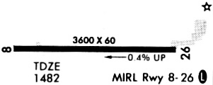
| Runways: | 09/27 |
| Longest Runway: | 09/27 is 3599 ft (1097 m) long |
| Runways with an Instrument Approach: |
94K Airport Runway Details
| Runway 09/27 | 3599 ft x 60 ft (1097 m x 18 m) | |
| Runway Length Source: | 3RD PARTY SURVEY as of 11/11/2011 | |
| Surface: | Asphalt - Poor condition - No special surface treatment | |
| Runway Edge Lights: | Medium Intensity | |
Runway Weight Bearing Capacity (in thousands of pounds) |
||
| Single Wheel Landing Gear: | 8.0 | |
Runway 09 |
Runway 27 |
|
Elevation: |
1479.4 | 1471.5 |
Latitude: |
36-41-50.5584N | 36-41-50.7588N |
Longitude: |
093-54-23.9872W | 093-53-39.7955W |
|
Runway True Alignment: |
090 | 270 |
Glide Path Angle: |
3.0 degrees | 3.0 degrees |
Traffic Pattern: |
Left | Left |
Runway Markings Type: |
Nonprecision Instrument | Nonprecision Instrument |
Runway Markings Condition: |
Good | Good |
Visual Glide Slope Indicators: |
2-Light PAPI On Left Side Of Runway | 2-Light PAPI On Left Side Of Runway |
Threshold Crossing Height: |
40 | 40 |
Services
Airframe Repair: |
Major |
Powerplant Repair: |
Major |
Bottled Oxygen: |
None |
Bulk Oxygen: |
None |
Fuel Available: |
100LL |
Landing Fees: |
No |
Parking: |
Tiedowns available |
Maps & Diagrams
94K Sectional
Flight Planning
at skyvector.com
at skyvector.com