Location
Latitude: |
42-48-51.2000N (42.814222) |
Longitude: |
077-12-10.5000W (-77.202917) |
Elevation: |
1080.0 feet MSL (329 m MSL) |
Magnetic Variation: |
11.4 W (as of April 2024 from WMM2020 model) |
Time Zone: |
UTC -5.0 (Standard Time) UTC -4.0 (Daylight Savings Time) |
From City: |
03 N.M. W of Gorham, New York |
Found On: |
Detroit Chart |
FAA Region: |
AEA |
Contacts
Manager: |
Privately owned: |
| J TRAVIS YATES 3730 LAKE TO LAKE ROAD STANLEY, NY 14561 585-764-1802 |
J TRAVIS YATES 3730 LAKE TO LAKE ROAD STANLEY, NY 14561 585-764-1802 |
Operations
Airport Status: |
Operational |
Facility Use: |
Public |
Type: |
Airport |
Activation Date: |
09/1980 |
Control tower: |
No |
Attendance (Months/Days/Hours): |
Months/Days/Hours ALL/MON-FRI/IRREG |
Boundary ARTCC: |
ZOB (Cleveland) |
Responsible ARTCC: |
ZOB (Cleveland) |
Segmented Circle Indicator: |
No |
Traffic Pattern Altitude (MSL): |
2080 feet (634 m) |
NOTAMs Facility: |
BUF |
NOTAM-D Service: |
Yes |
Based Aircraft
| Single Engine: | 3 |
Annual Operations (as of 07/11/2019)
| Total Operations: | 148 | |
| GA Local: | 100 | 67.6% |
| GA Itinerant: | 48 | 32.4% |
Communications
| CTAF: | 122.800 |
| Unicom: | 122.800 |
Fixed Based Operators (FBOs) & Fuel
(Click on a business for detail)
Please help us keep this information up to date. This is a FREE SERVICE just like everything else on Airport Guide! If you see that a business needs to be added, modified, or deleted please fill out our Update Form.
To add, modify, or delete a business click here.
Please help us keep this information up to date. This is a FREE SERVICE just like everything else on Airport Guide! If you see that a business needs to be added, modified, or deleted please fill out our Update Form.
Area Code: 716 |
| Business Name | Frequency | Phone | Fuel Grade |
|---|
Flight Service Stations
| Primary | Alternate | |
| FSS on Field: | N | |
| FSS Name (ID): | Buffalo(BUF) | |
| Frequency: | ||
| Toll Free Phone: | 1-800-WX-BRIEF |
Instrument Procedures / Charts
Terminal Procedures are only available for airports in several countries with more being added all the time. If you are looking for a specific country's charts, please send an email to support(at)airportguide.com stating the country name. This will be used to prioritize the implementation.
Navigation Aids (Navaids) near 92G
| Dist (NM) | ID | Morse Code | Name | Type | Freq | True Hdg | Mag Hdg |
|---|---|---|---|---|---|---|---|
| 12.1 | PYA | . _ _ . _ . _ _ . _ | Penn Yan | NDB | 260 | 147 | 158 |
| 23.3 | GEE | _ _ . . . | Geneseo | VOR-DME | 108.20 | 273 | 284 |
| 27.5 | AVN | . _ . . . _ _ . | Avon | NDB | 344 | 295 | 306 |
| 27.5 | ROC | . _ . _ _ _ _ . _ . | Rochester | VOR-DME | 110.00 | 311 | 322 |
| 38.0 | ITH | . . _ . . . . | Ithaca | DME | 111.8 | 120 | 132 |
| 39.6 | ALP | . _ . _ . . . _ _ . | Alpine | NDB | 245 | 150 | 161 |
| 43.5 | IT | . . _ | Vrnah | NDB | 266 | 121 | 133 |
| 43.9 | ULW | . . _ . _ . . . _ _ | Elmira | VOR-DME | 109.65 | 169 | 180 |
| 48.5 | SYR | . . . _ . _ _ . _ . | Syracuse | VORTAC | 117.00 | 64 | 76 |
| 48.6 | FZ | . . _ . _ _ . . | Falln | NDB | 220 | 53 | 65 |
| 56.0 | ELZ | . . _ . . _ _ . . | Wellsville | DME | 115.85 | 219 | 230 |
| 59.3 | LYS | . _ . . _ . _ _ . . . | Olean | NDB | 360 | 237 | 248 |
| 60.6 | GGT | _ _ . _ _ . _ | Georgetown | TACAN | 117.80 | 90 | 102 |
| 61.5 | CFB | _ . _ . . . _ . _ . . . | Binghamton | VOR-DME | 112.20 | 129 | 141 |
| 63.8 | BUF | _ . . . . . _ . . _ . | Buffalo | DME | 116.4 | 276 | 287 |
| 64.6 | BU | _ . . . . . _ | Klump | NDB | 231 | 280 | 291 |
| 67.7 | BUF | _ . . . . . _ . . _ . | Buffalo | VOT | 109.00 | 276 | 287 |
| 67.8 | SFK | . . . . . _ . _ . _ | Stonyfork | VOR-DME | 108.60 | 188 | 199 |
| 71.1 | GB | _ _ . _ . . . | Plazz | NDB | 204 | 273 | 284 |
| 72.0 | BG | _ . . . _ _ . | Smite | NDB | 332 | 125 | 137 |
Nearby Airports with Fuel
Notices to Airmen (NOTAMS)
Remarks
| A110-3 | RY 14/32 SOFT & WET DURG MAR-JUN. |
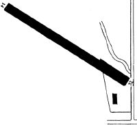
| A110-4 | RY 32 HAS +80 FT TREES 735 FT FM THLD +80 FT L/R OF CNTRLN. |
| A110-5 | FOR CD CTC CLEVELAND ARTCC AT 440-774-0490. |
| A42-14 | RY 14/32 MRKD WITH ORANGE CONES. |
| A52-14 | MARKED POWER POLES 2700 FT FROM THLD; +20 FT BRUSH 50 FT FROM THLD BOTH SIDES OF CNTRLN; +57 FT TREE 710 FT FROM THLD 177 FT R. |
| A52-32 | POWER POLES MARKED 1300 FT FM THLD. TREES 735 FT FM THLD+80' L/R OF CENTERLINE. |
| E111 | VFR USE ONLY. |
Runways
Runway Summary
| Runways: | 14/32 |
| Longest Runway: | 14/32 is 1820 ft (555 m) long |
| Runways with an Instrument Approach: |
92G Airport Runway Details
| Runway 14/32 | 1820 ft x 55 ft (555 m x 17 m) | |
| Surface: | Turf - Fair condition - No special surface treatment | |
Runway 14 |
Runway 32 |
|
Elevation: |
1058.0 | 1078.0 |
Latitude: |
42-48-56.1954N | 42-48-46.2542N |
Longitude: |
077-12-20.6420W | 077-12-00.2897W |
|
Runway True Alignment: |
124 | 304 |
Glide Path Angle: |
0.0 degrees | 0.0 degrees |
Object at End: |
TREES | ROAD |
Object Height: |
18 | 78 |
Distance from End: |
41 | 801 |
Object Centerline Offset: |
69 ft. right of centerline | 0 ft. right of centerline |
Services
Airframe Repair: |
None |
Powerplant Repair: |
None |
Bottled Oxygen: |
None |
Bulk Oxygen: |
None |
Fuel Available: |
100LL |
Landing Fees: |
No |
Parking: |
Tiedowns available |
Maps & Diagrams
92G Sectional
Flight Planning
at skyvector.com
at skyvector.com