Location
Latitude: |
40-14-52.2950N (40.24786) |
Longitude: |
081-44-09.8500W (-81.736069) |
Elevation: |
844.0 feet MSL (257 m MSL) |
Magnetic Variation: |
8.1 W (as of April 2024 from WMM2020 model) |
Time Zone: |
UTC -5.0 (Standard Time) UTC -4.0 (Daylight Savings Time) |
From City: |
02 N.M. SE of West Lafayette, Ohio |
Found On: |
Detroit Chart |
FAA Region: |
AGL |
Contacts
Manager: |
Privately owned: |
| DAVID ZIMMER 20629 STATE ROUTE 93 WEST LAFAYETTE, OH 43845-9786 740-545-7580 |
DAVID ZIMMER 20670 STATE ROUTE 93 WEST LAFAYETTE, OH 43845 740-545-7580 |
Operations
Airport Status: |
Operational |
Facility Use: |
Public |
Type: |
Airport |
Activation Date: |
04/1978 |
Control tower: |
No |
Attendance (Months/Days/Hours): |
Months/Days/Hours ALL/ALL/IREG |
Boundary ARTCC: |
ZID (Indianapolis) |
Responsible ARTCC: |
ZID (Indianapolis) |
Segmented Circle Indicator: |
No |
Traffic Pattern Altitude (MSL): |
1844 feet (562 m) |
NOTAMs Facility: |
CLE |
NOTAM-D Service: |
Yes |
Based Aircraft
| Single Engine: | 4 |
| Ultralights: | 4 |
Annual Operations (as of 08/16/2022)
| Total Operations: | 900 | |
| GA Local: | 500 | 55.6% |
| GA Itinerant: | 400 | 44.4% |
Communications
| CTAF: | 122.900 |
Fixed Based Operators (FBOs) & Fuel
(Click on a business for detail)
Please help us keep this information up to date. This is a FREE SERVICE just like everything else on Airport Guide! If you see that a business needs to be added, modified, or deleted please fill out our Update Form.
To add, modify, or delete a business click here.
Please help us keep this information up to date. This is a FREE SERVICE just like everything else on Airport Guide! If you see that a business needs to be added, modified, or deleted please fill out our Update Form.
Area Code: 614 |
| Business Name | Frequency | Phone | Fuel Grade |
|---|---|---|---|
| Zimmer Flying Service
Update FBO info |
Unicom 122.9 | 545-9135 | 80, 100LL |
Flight Service Stations
| Primary | Alternate | |
| FSS on Field: | N | |
| FSS Name (ID): | Cleveland(CLE) | |
| Frequency: | ||
| Toll Free Phone: | 1-800-WX-BRIEF |
Instrument Procedures / Charts
Terminal Procedures are only available for airports in several countries with more being added all the time. If you are looking for a specific country's charts, please send an email to support(at)airportguide.com stating the country name. This will be used to prioritize the implementation.
Navigation Aids (Navaids) near 80G
| Dist (NM) | ID | Morse Code | Name | Type | Freq | True Hdg | Mag Hdg |
|---|---|---|---|---|---|---|---|
| 11.9 | CTW | _ . _ . _ . _ _ | Newcomerstown | DME | 111.8 | 95 | 103 |
| 18.7 | MLR | _ _ . _ . . . _ . | Millersburg/Dcmsnd | NDB | 382 | 340 | 348 |
| 19.8 | ZZV | _ _ . . _ _ . . . . . _ | Zanesville | VOR-DME | 114.95 | 201 | 209 |
| 22.2 | HRA | . . . . . _ . . _ | Zanesville | NDB | 204 | 202 | 210 |
| 32.7 | BSV | _ . . . . . . . . . _ | Briggs | VOR-DME | 112.40 | 25 | 33 |
| 33.1 | CFX | _ . _ . . . _ . _ . . _ | Cadiz | NDB | 239 | 90 | 98 |
| 35.9 | HEH | . . . . . . . . . | Newark | NDB | 524 | 248 | 256 |
| 39.5 | APE | . _ . _ _ . . | Appleton | VORTAC | 116.70 | 261 | 269 |
| 42.3 | CAK | _ . _ . . _ _ . _ | Akron/Canton Regional | VOT | 110.60 | 18 | 26 |
| 44.4 | AIR | . _ . . . _ . | Bellaire | VOR-DME | 117.10 | 107 | 115 |
| 44.9 | MF | _ _ . . _ . | Manns | NDB | 372 | 314 | 322 |
| 49.0 | AAU | . _ . _ . . _ | Ashland | NDB | 329 | 331 | 339 |
| 49.3 | CM | _ . _ . _ _ | Sumie | NDB | 391 | 251 | 259 |
| 51.2 | JPU | . _ _ _ . _ _ . . . _ | Parkersburg | VOR-DME | 114.45 | 160 | 168 |
| 51.8 | AK | . _ _ . _ | Akron | NDB | 362 | 17 | 25 |
| 53.5 | HLG | . . . . . _ . . _ _ . | Wheeling | VOR-DME | 114.25 | 88 | 97 |
| 53.8 | PKB | . _ _ . _ . _ _ . . . | Marietta Ohio | FAN MARKER | 163 | 171 | |
| 53.9 | MFD | _ _ . . _ . _ . . | Mansfield | VORTAC | 108.80 | 313 | 321 |
| 54.9 | CMH | _ . _ . _ _ . . . . | Port Columbus | VOT | 111.00 | 254 | 262 |
| 55.1 | LC | . _ . . _ . _ . | Pickl | NDB | 376 | 246 | 254 |
Nearby Airports with Fuel
Notices to Airmen (NOTAMS)
Remarks
| A110-1 | FOR CD CTC INDIANAPOLIS ARTCC AT 317-247-2411. |
| A110-2 | DAYTIME VFR USE ONLY. |
| A16 | CELL 740-545-7580. |
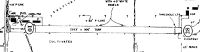
| A23-28 | DUE TO 280 FT HILLS, 2500 FT WSW. |
| A33-10/28 | ROUGH. |
| A52-10 | ALSO 270 FT WOODED HILL, 2100 FT DIST. |
Runways
Runway Summary
| Runways: | 10/28 |
| Longest Runway: | 10/28 is 3000 ft (914 m) long |
| Runways with an Instrument Approach: |
80G Airport Runway Details
| Runway 10/28 | 3000 ft x 100 ft (914 m x 30 m) | |
| Runway Length Source: | OWNER as of 07/29/2020 | |
| Surface: | Turf - Fair condition - No special surface treatment | |
Runway 10 |
Runway 28 |
|
Elevation: |
844.0 | 844.0 |
Latitude: |
40-14-52.8300N | 40-14-51.7600N |
Longitude: |
081-44-29.1800W | 081-43-50.5200W |
|
Runway True Alignment: |
092 | 272 |
Glide Path Angle: |
0.0 degrees | 0.0 degrees |
Traffic Pattern: |
Left | Right |
Object at End: |
PLINE | CROPS |
Object Height: |
25 | 12 |
Distance from End: |
0 | 20 |
Object Centerline Offset: |
0 ft. left and right of centerline | 0 ft. left and right of centerline |
REIL: |
No | No |
Touchdown Lights: |
No | No |
Centerline Lights: |
No | No |
Displaced Threshold: |
453 | |
Threshold Latitude: |
40-14-52.6686N | |
Threshold Longitude: |
081-44-23.3417W |
Services
Airframe Repair: |
Minor |
Powerplant Repair: |
Minor |
Bottled Oxygen: |
None |
Bulk Oxygen: |
None |
Fuel Available: |
100LL, Jet A, Jet A+ |
Landing Fees: |
No |
Parking: |
Hangars and tiedowns available |
Maps & Diagrams
80G Sectional
Flight Planning
at skyvector.com
at skyvector.com