Location
Latitude: |
37-38-00.5170N (37.633477) |
Longitude: |
085-14-30.6170W (-85.241838) |
Elevation: |
871.1 feet MSL (266 m MSL) |
Magnetic Variation: |
5.4 W (as of April 2024 from WMM2020 model) |
Time Zone: |
UTC -5.0 (Standard Time) UTC -4.0 (Daylight Savings Time) |
From City: |
03 N.M. S of Springfield, Kentucky |
Found On: |
St Louis Chart |
FAA Region: |
ASO |
Contacts
Manager: |
Publicly owned: |
| CHRIS CARTER 650 AIRPORT LANE SPRINGFIELD, KY 40069 859-336-3818 |
MARION-WASHINGTON COUNTIES PO BOX 805 LEBANON, KY 40033 (859) 336-3818 |
Operations
Airport Status: |
Operational |
Facility Use: |
Public |
Type: |
Airport |
Activation Date: |
12/1963 |
Control tower: |
No |
Attendance (Months/Days/Hours): |
Months/Days/Hours ALL/MON-SAT/0900-1800 |
Boundary ARTCC: |
ZID (Indianapolis) |
Responsible ARTCC: |
ZID (Indianapolis) |
Lighting Schedule: |
SEE RMK |
Segmented Circle Indicator: |
Yes |
Traffic Pattern Altitude (MSL): |
1871 feet (570 m) |
NOTAMs Facility: |
LOU |
NOTAM-D Service: |
Yes |
International Airport of Entry: |
No |
Customs Landing Rights: |
No |
Military Landing Rights: |
Yes |
Civil/Military Joint Use: |
No |
Based Aircraft
| Single Engine: | 19 |
| GA Helicopters: | 1 |
Annual Operations (as of 04/04/2018)
| Total Operations: | 9870 | |
| Air Taxi: | 1575 | 16.0% |
| GA Local: | 3675 | 37.2% |
| GA Itinerant: | 4410 | 44.7% |
| Military Aircraft: | 210 | 2.1% |
Communications
| CTAF: | 122.800 |
| Unicom: | 122.800 |
| AWOS-3P: | 119.725 (859-336-0340) |
- APCH/DEP SVC PRVDD BY INDIANAPOLIS ARTCC ON FREQS 124.625/371.925 (NEW HOPE RCAG).
Fixed Based Operators (FBOs) & Fuel
(Click on a business for detail)
Please help us keep this information up to date. This is a FREE SERVICE just like everything else on Airport Guide! If you see that a business needs to be added, modified, or deleted please fill out our Update Form.
To add, modify, or delete a business click here.
Please help us keep this information up to date. This is a FREE SERVICE just like everything else on Airport Guide! If you see that a business needs to be added, modified, or deleted please fill out our Update Form.
Area Code: 859 |
| Business Name | Frequency | Phone | Fuel Grade |
|---|
Flight Service Stations
| Primary | Alternate | |
| FSS on Field: | N | |
| FSS Name (ID): | Louisville(LOU) | |
| Frequency: | ||
| Toll Free Phone: | 1-800-WX-BRIEF |
Instrument Procedures / Charts
FAA Terminal Procedures valid from 0901Z 03/21/24 to 0901Z 04/18/24.
There are various types of charts available for an airport. They are listed in the Page Type column. Here is a legend for those types:
APD - Airport Diagram
DP - Departure Procedure Charts
HOT - Hot Spots
IAP - Instrument Approach Procedure Charts
MIN - Minimums
STAR - Standard Terminal Arrival Charts
| Page Type | Page Name | Volume | Action Since Last Cycle |
|---|---|---|---|
| IAP | RNAV (GPS) RWY 11 | SE-1 | |
| IAP | RNAV (GPS) RWY 29 | SE-1 | |
| IAP | VOR/DME RWY 11 | SE-1 | |
| MIN | ALTERNATE MINIMUMS | SE-1 | |
| MIN | TAKEOFF MINIMUMS | SE-1 |
Terminal Procedures are only available for airports in several countries with more being added all the time. If you are looking for a specific country's charts, please send an email to support(at)airportguide.com stating the country name. This will be used to prioritize the implementation.
Navigation Aids (Navaids) near 6I2
| Dist (NM) | ID | Morse Code | Name | Type | Freq | True Hdg | Mag Hdg |
|---|---|---|---|---|---|---|---|
| 0.3 | IKY | . . _ . _ _ . _ _ | Springfield | NDB | 429 | 74 | 79 |
| 13.9 | TYC | _ _ . _ _ _ . _ . | Taylor County | NDB | 272 | 180 | 185 |
| 17.2 | BRY | _ . . . . _ . _ . _ _ | Bardstown/Dcmsnd | NDB | 248 | 318 | 323 |
| 20.6 | EWO | . . _ _ _ _ _ | New Hope | VOR-DME | 113.95 | 269 | 274 |
| 23.0 | DVK | _ . . . . . _ _ . _ | Goodall | NDB | 311 | 98 | 104 |
| 32.4 | IIU | . . . . . . _ | Louisville | VORTAC | 114.80 | 330 | 335 |
| 34.8 | LE | . _ . . . | Blayd | NDB | 242 | 52 | 58 |
| 35.8 | LK | . _ . . _ . _ | Laang | NDB | 414 | 328 | 333 |
| 36.5 | FFT | . . _ . . . _ . _ | Frankfort | VOR | 109.40 | 25 | 31 |
| 38.4 | FTK | . . _ . _ _ . _ | Fort Knox | VOR-DME | 109.60 | 295 | 300 |
| 39.9 | GOI | _ _ . _ _ _ . . | Godman | NDB | 396 | 299 | 304 |
| 40.7 | SDF | . . . _ . . . . _ . | Louisville Standifd | VOT | 111.00 | 324 | 329 |
| 41.0 | BQM | _ . . . _ _ . _ _ _ | Bowman | DME | 112.2 | 330 | 335 |
| 41.6 | HYK | . . . . _ . _ _ _ . _ | Lexington | VOR-DME | 112.60 | 61 | 67 |
| 45.6 | GN | _ _ . _ . | Bridl | NDB | 340 | 49 | 55 |
| 46.7 | CDX | _ . _ . _ . . _ . . _ | Cumberland River | NDB | 388 | 144 | 150 |
| 50.1 | MYS | _ _ _ . _ _ . . . | Mystic | VOR | 108.20 | 288 | 293 |
| 52.0 | BVQ | _ . . . . . . _ _ _ . _ | Beaver Creek | NDB | 260 | 224 | 229 |
| 55.6 | JV | . _ _ _ . . . _ | Catch | NDB | 331 | 335 | 340 |
| 58.0 | XYC | _ . . _ _ . _ _ _ . _ . | Seco | NDB | 393 | 82 | 88 |
Nearby Airports with Fuel
Notices to Airmen (NOTAMS)
Remarks
| A110-2 | FOR CD CTC INDIANAPOLIS ARTCC AT 317-247-2411. |
| A30A-29 | TREES NE VIOLATE 7:1 TRSN SFC. |
| A5 | AND MARION CO. |
| A57-29 | APCH RATIO 30:1 TO DTHR. |
| A70-FUEL-10 | 0LL AVBL 24/7 WITH CC. |
| A81-APT | ACTVT REIL RWY 11 & 29; PAPI RWY 11 & 29 ; MIRL RWY 11/29 - CTAF. |
| E111 | VFR USE ONLY. |
Runways
Runway Summary
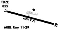
| Runways: | 11/29 |
| Longest Runway: | 11/29 is 5001 ft (1524 m) long |
| Runways with an Instrument Approach: |
6I2 Airport Runway Details
| Runway 11/29 | 5001 ft x 75 ft (1524 m x 23 m) | |
| Runway Length Source: | 3RD PARTY SURVEY as of 06/09/2011 | |
| Surface: | Asphalt - Good condition - No special surface treatment | |
| Runway Pavement Class: | 17 /F/D/X/T | |
| Runway Edge Lights: | Medium Intensity | |
Runway 11 |
Runway 29 |
|
Elevation: |
821.9 | 871.0 |
Latitude: |
37-38-06.9547N | 37-37-54.0790N |
Longitude: |
085-15-00.6215W | 085-14-00.6073W |
|
Runway True Alignment: |
105 | 285 |
Glide Path Angle: |
3.0 degrees | 3.3 degrees |
Traffic Pattern: |
Left | Left |
Runway Markings Type: |
Nonprecision Instrument | Nonprecision Instrument |
Runway Markings Condition: |
Good | Good |
Object at End: |
TREE | |
Object Height: |
77 | |
Distance from End: |
2115 | |
Object Centerline Offset: |
174 ft. left of centerline | |
Visual Glide Slope Indicators: |
4-Light PAPI On Left Side Of Runway | 4-Light PAPI On Left Side Of Runway |
REIL: |
Yes | Yes |
Threshold Crossing Height: |
36 | 27 |
Threshold Elevation: |
823.3 | 869.6 |
Displaced Threshold: |
125 | 200 |
Threshold Latitude: |
37-38-06.6353N | 37-37-54.5949N |
Threshold Longitude: |
085-14-59.1210W | 085-14-03.0098W |
Services
Fuel Available: |
100LL |
Landing Fees: |
No |
Parking: |
Tiedowns available |
Maps & Diagrams
6I2 Sectional
Flight Planning
at skyvector.com
at skyvector.com