Location
Latitude: |
39-46-44.5850N (39.779051) |
Longitude: |
081-06-10.0100W (-81.102781) |
Elevation: |
1197.1 feet MSL (365 m MSL) |
Magnetic Variation: |
8.5 W (as of April 2024 from WMM2020 model) |
Time Zone: |
UTC -5.0 (Standard Time) UTC -4.0 (Daylight Savings Time) |
From City: |
01 N.M. N of Woodsfield, Ohio |
Found On: |
Cincinnati Chart |
FAA Region: |
AGL |
Contacts
Manager: |
Publicly owned: |
| DAVID DALRYMPLE 47073 STATE ROUTE 26 WOODSFIELD, OH 43793-9330 740-472-1882 |
MONROE COUNTY COMMISSIONERS 101 N MAIN ST WOODSFIELD, OH 43793-1070 740-472-1341 |
Operations
Airport Status: |
Operational |
Facility Use: |
Public |
Type: |
Airport |
Activation Date: |
03/1969 |
Control tower: |
No |
Attendance (Months/Days/Hours): |
Months/Days/Hours IREG |
Boundary ARTCC: |
ZOB (Cleveland) |
Responsible ARTCC: |
ZOB (Cleveland) |
Lighting Schedule: |
SEE RMK |
Segmented Circle Indicator: |
No |
Traffic Pattern Altitude (MSL): |
2197 feet (670 m) |
NOTAMs Facility: |
CLE |
NOTAM-D Service: |
Yes |
International Airport of Entry: |
No |
Customs Landing Rights: |
No |
Military Landing Rights: |
No |
Civil/Military Joint Use: |
No |
Based Aircraft
| Single Engine: | 10 |
| GA Helicopters: | 4 |
Annual Operations (as of 06/30/2020)
| Total Operations: | 1024 | |
| Air Taxi: | 10 | 1.0% |
| GA Local: | 100 | 9.8% |
| GA Itinerant: | 860 | 84.0% |
| Military Aircraft: | 54 | 5.3% |
Communications
| CTAF: | 122.800 |
| Unicom: | 122.800 |
- APCH/DEP SVC PRVDD BY CLEVELAND ARTCC ON FREQS 126.95/239.30 (BELMONT RCAG).
Fixed Based Operators (FBOs) & Fuel
(Click on a business for detail)
Please help us keep this information up to date. This is a FREE SERVICE just like everything else on Airport Guide! If you see that a business needs to be added, modified, or deleted please fill out our Update Form.
To add, modify, or delete a business click here.
Please help us keep this information up to date. This is a FREE SERVICE just like everything else on Airport Guide! If you see that a business needs to be added, modified, or deleted please fill out our Update Form.
Area Code: 740 |
| Business Name | Frequency | Phone | Fuel Grade |
|---|---|---|---|
| Monroe County Airport
Update FBO info |
Unicom 122.8 | 472-1882, -2060 | 80, 100LL |
Flight Service Stations
| Primary | Alternate | |
| FSS on Field: | N | |
| FSS Name (ID): | Cleveland(CLE) | |
| Frequency: | ||
| Toll Free Phone: | 1-800-WX-BRIEF |
Instrument Procedures / Charts
FAA Terminal Procedures valid from 0901Z 03/21/24 to 0901Z 04/18/24.
There are various types of charts available for an airport. They are listed in the Page Type column. Here is a legend for those types:
APD - Airport Diagram
DP - Departure Procedure Charts
HOT - Hot Spots
IAP - Instrument Approach Procedure Charts
MIN - Minimums
STAR - Standard Terminal Arrival Charts
| Page Type | Page Name | Volume | Action Since Last Cycle |
|---|---|---|---|
| IAP | RNAV (GPS) RWY 25 | EC-2 | |
| IAP | VOR/DME RWY 25 | EC-2 | |
| MIN | TAKEOFF MINIMUMS | EC-2 |
Terminal Procedures are only available for airports in several countries with more being added all the time. If you are looking for a specific country's charts, please send an email to support(at)airportguide.com stating the country name. This will be used to prioritize the implementation.
Navigation Aids (Navaids) near 4G5
| Dist (NM) | ID | Morse Code | Name | Type | Freq | True Hdg | Mag Hdg |
|---|---|---|---|---|---|---|---|
| 19.4 | AIR | . _ . . . _ . | Bellaire | VOR-DME | 117.10 | 42 | 51 |
| 23.9 | JPU | . _ _ _ . _ _ . . . _ | Parkersburg | VOR-DME | 114.45 | 211 | 219 |
| 27.7 | PKB | . _ _ . _ . _ _ . . . | Marietta Ohio | FAN MARKER | 211 | 219 | |
| 27.8 | CFX | _ . _ . . . _ . _ . . _ | Cadiz | NDB | 239 | 8 | 17 |
| 32.0 | CTW | _ . _ . _ . _ _ | Newcomerstown | DME | 111.8 | 327 | 335 |
| 36.1 | PK | . _ _ . _ . _ | Versi | NDB | 388 | 209 | 217 |
| 37.7 | ZZV | _ _ . . _ _ . . . . . _ | Zanesville | VOR-DME | 114.95 | 285 | 293 |
| 37.9 | HLG | . . . . . _ . . _ _ . | Wheeling | VOR-DME | 114.25 | 40 | 49 |
| 38.4 | HRA | . . . . . _ . . _ | Zanesville | NDB | 204 | 281 | 289 |
| 49.9 | CKB | _ . _ . _ . _ _ . . . | Clarksburg | VOR-DME | 112.60 | 128 | 137 |
| 56.8 | UGS | . . _ _ _ . . . . | University | NDB | 250 | 236 | 244 |
| 57.3 | AGC | . _ _ _ . _ . _ . | Allegheny | VOR-DME | 110.00 | 58 | 67 |
| 57.8 | MLR | _ _ . _ . . . _ . | Millersburg/Dcmsnd | NDB | 382 | 322 | 330 |
| 58.9 | MGW | _ _ _ _ . . _ _ | Morgantown | VOR-DME | 111.60 | 102 | 111 |
| 59.6 | MMJ | _ _ _ _ . _ _ _ | Montour | DME | 112 | 44 | 53 |
| 59.6 | BSV | _ . . . . . . . . . _ | Briggs | VOR-DME | 112.40 | 345 | 353 |
| 60.5 | UNI | . . _ _ . . . | Athens | FAN MARKER | 237 | 245 | |
| 62.9 | VV | . . . _ . . . _ | Camor | NDB | 299 | 83 | 92 |
| 64.4 | HEH | . . . . . . . . . | Newark | NDB | 524 | 283 | 291 |
| 69.7 | EKN | . _ . _ _ . | Elkins | VORTAC | 114.20 | 137 | 146 |
Nearby Airports with Fuel
Notices to Airmen (NOTAMS)
Remarks
| A110-1 | OCNL DEER, BIRDS, & OTR WILDLIFE ON & INVOF ARPT. |
| A110-2 | FOR CD CTC CLEVELAND ARTCC AT 440-774-0226. |
| A16 | CELL 740-213-3106. |
| A57-07 | APCH RATIO 17:1 TO DTHR. |
| A58-25 | 0-15 FT TREES & BRUSH, 0-200 FT DIST, 135-210 FT L. |
| A70-FUEL-10 | 0LL FULL SER ONLY CALL AMGR CELL. |
| A81-APT | ACTVT REIL RWY 25; MIRL RWY 07/25 - CTAF. PAPI RWY 25 OPR CONSLY. |
Runways
Runway Summary
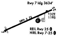
| Runways: | 07/25 |
| Longest Runway: | 07/25 is 3805 ft (1160 m) long |
| Runways with an Instrument Approach: |
4G5 Airport Runway Details
| Runway 07/25 | 3805 ft x 75 ft (1160 m x 23 m) | |
| Runway Length Source: | 3RD PARTY SURVEY as of 07/29/2020 | |
| Surface: | Asphalt - Good condition - No special surface treatment | |
| Runway Edge Lights: | Medium Intensity | |
Runway Weight Bearing Capacity (in thousands of pounds) |
||
| Single Wheel Landing Gear: | 18.0 | |
Runway 07 |
Runway 25 |
|
Elevation: |
1193.9 | 1190.7 |
Latitude: |
39-46-36.9376N | 39-46-52.2310N |
Longitude: |
081-06-32.2715W | 081-05-47.7466W |
|
Runway True Alignment: |
066 | 246 |
Glide Path Angle: |
0.0 degrees | 3.0 degrees |
Traffic Pattern: |
Left | Left |
Runway Markings Type: |
Nonprecision Instrument | Nonprecision Instrument |
Runway Markings Condition: |
Good | Good |
Object at End: |
TREES | TREES |
Object Height: |
140 | 23 |
Distance from End: |
1582 | 238 |
Object Centerline Offset: |
260 ft. right of centerline | 140 ft. left of centerline |
Visual Glide Slope Indicators: |
2-Light PAPI On Left Side Of Runway | |
REIL: |
Yes | |
Threshold Crossing Height: |
40 | |
Threshold Elevation: |
1194.3 | |
Displaced Threshold: |
174 | |
Threshold Latitude: |
39-46-37.6377N | |
Threshold Longitude: |
081-06-30.2332W |
Services
Airframe Repair: |
Minor |
Powerplant Repair: |
Minor |
Bottled Oxygen: |
None |
Bulk Oxygen: |
None |
Fuel Available: |
80, 100LL |
Landing Fees: |
No |
Parking: |
Hangars and tiedowns available |
Maps & Diagrams
4G5 Sectional
Flight Planning
at skyvector.com
at skyvector.com