Location
Latitude: |
39-26-15.2230N (39.437562) |
Longitude: |
083-42-29.7220W (-83.708256) |
Elevation: |
1090.0 feet MSL (332 m MSL) |
Magnetic Variation: |
6.7 W (as of April 2024 from WMM2020 model) |
Time Zone: |
UTC -5.0 (Standard Time) UTC -4.0 (Daylight Savings Time) |
From City: |
05 N.M. E of Wilmington, Ohio |
Found On: |
Cincinnati Chart |
FAA Region: |
AGL |
Contacts
Manager: |
Privately owned: |
| MATTHEW W ELLIS 2326 CHERRYBEND RD WILMINGTON, OH 45177-9312 937-584-4269 |
MATTHEW W ELLIS 2326 CHERRYBEND RD WILMINGTON, OH 45177-9312 937-584-4269 |
Operations
Airport Status: |
Operational |
Facility Use: |
Public |
Type: |
Airport |
Activation Date: |
03/1962 |
Control tower: |
No |
Attendance (Months/Days/Hours): |
Months/Days/Hours ALL/ALL/DALGT |
Boundary ARTCC: |
ZID (Indianapolis) |
Responsible ARTCC: |
ZID (Indianapolis) |
Segmented Circle Indicator: |
No |
Traffic Pattern Altitude (MSL): |
2090 feet (637 m) |
NOTAMs Facility: |
DAY |
NOTAM-D Service: |
Yes |
International Airport of Entry: |
No |
Customs Landing Rights: |
No |
Based Aircraft
| Single Engine: | 3 |
Annual Operations (as of 07/27/2021)
| Total Operations: | 250 | |
| GA Local: | 100 | 40.0% |
| GA Itinerant: | 150 | 60.0% |
Communications
| CTAF: | 122.900 |
Fixed Based Operators (FBOs) & Fuel
(Click on a business for detail)
Please help us keep this information up to date. This is a FREE SERVICE just like everything else on Airport Guide! If you see that a business needs to be added, modified, or deleted please fill out our Update Form.
To add, modify, or delete a business click here.
Please help us keep this information up to date. This is a FREE SERVICE just like everything else on Airport Guide! If you see that a business needs to be added, modified, or deleted please fill out our Update Form.
Area Code: 937 |
| Business Name | Frequency | Phone | Fuel Grade |
|---|
Flight Service Stations
| Primary | Alternate | |
| FSS on Field: | N | |
| FSS Name (ID): | Dayton(DAY) | |
| Frequency: | ||
| Toll Free Phone: | 1-800-WX-BRIEF |
Instrument Procedures / Charts
Terminal Procedures are only available for airports in several countries with more being added all the time. If you are looking for a specific country's charts, please send an email to support(at)airportguide.com stating the country name. This will be used to prioritize the implementation.
Navigation Aids (Navaids) near 2B6
| Dist (NM) | ID | Morse Code | Name | Type | Freq | True Hdg | Mag Hdg |
|---|---|---|---|---|---|---|---|
| 3.6 | IL | . . . _ . . | Airbo | NDB | 407 | 337 | 344 |
| 4.3 | MXQ | _ _ _ . . _ _ _ . _ | Midwest | VOR-DME | 112.90 | 263 | 270 |
| 9.3 | HW | . . . . . _ _ | Cubla | NDB | 299 | 237 | 244 |
| 17.0 | HOC | . . . . _ _ _ _ . _ . | Hillsboro | NDB | 278 | 153 | 160 |
| 17.6 | CSS | _ . _ . . . . . . . | Court House | NDB | 414 | 56 | 63 |
| 24.8 | SGH | . . . _ _ . . . . . | Springfield | DME | 113.2 | 345 | 352 |
| 24.8 | XSF | _ . . _ . . . . . _ . | Springfield | TACAN | 133.80 | 345 | 352 |
| 26.4 | CCJ | _ . _ . _ . _ . . _ _ _ | Clark County | NDB | 341 | 352 | 359 |
| 28.0 | FFO | . . _ . . . _ . _ _ _ | Patterson | TACAN | 109.20 | 325 | 332 |
| 29.7 | MW | _ _ . _ _ | Onida | NDB | 223 | 286 | 293 |
| 31.5 | RZT | . _ . _ _ . . _ | Ross County | NDB | 236 | 89 | 96 |
| 32.0 | PWF | . _ _ . . _ _ . . _ . | Sportys | NDB | 245 | 227 | 234 |
| 32.7 | BU | _ . . . . . _ | Boutn | NDB | 230 | 45 | 52 |
| 32.7 | MDE | _ _ _ . . . | Madeira | NDB | 379 | 246 | 252 |
| 33.8 | LUK | . _ . . . . _ _ . _ | Cincinnati | NDB | 335 | 240 | 246 |
| 34.2 | XUB | _ . . _ . . _ _ . . . | Yellow Bud | VOR | 112.50 | 80 | 87 |
| 34.4 | HKF | . . . . _ . _ . . _ . | Hook Field | NDB | 239 | 276 | 282 |
| 35.6 | AMT | . _ _ _ _ | West Union | NDB | 359 | 169 | 176 |
| 35.7 | PZO | . _ _ . _ _ . . _ _ _ | Peebles | NDB | 329 | 150 | 157 |
| 36.2 | DAY | _ . . . _ _ . _ _ | Dayton J M Cox-Day | VOT | 111.00 | 319 | 326 |
Nearby Airports with Fuel
Notices to Airmen (NOTAMS)
Remarks
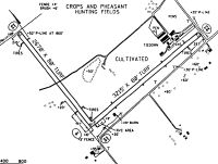
| A110-1 | PHEASANTS RELEASED N SIDE OF RWY FOR HUNTING SEP-APR. |
| A110-2 | MODEL ACFT RDO CTL AREA S OF RY 23. |
| A110-5 | CALL FOR RY COND PRIOR TO LDG FR NOV - APR. |
| A110-6 | RY 13/31 CLSD INDEFLY. |
| A110-7 | FOR CD CTC COLUMBUS APCH AT 614-338-8537 |
| A42-05 | 05/23 DSPLCD THLDS MKD WITH WHITE TIRES. |
| A57-05 | RWY 05 APCH RATIO 0:1 TO DSPLCD THLD. DUE TO CROPS |
| A57-23 | RWY 23 APCH RATIO 0:1 TO DSPLCD THLD. DUE TO CROPS |
| A75 | USERS PRVD OWN ROPES. |
Runways
Runway Summary
| Runways: | 05/23 13/31 |
| Longest Runway: | 05/23 is 3203 ft (976 m) long |
| Runways with an Instrument Approach: |
2B6 Airport Runway Details
| Runway 05/23 | 3203 ft x 80 ft (976 m x 24 m) | |
| Surface: | Turf - Good condition - No special surface treatment | |
Runway 05 |
Runway 23 |
|
Glide Path Angle: |
0.0 degrees | 0.0 degrees |
Traffic Pattern: |
Left | Left |
Object at End: |
CROPS | ROAD |
Object Height: |
10 | 16 |
Distance from End: |
20 | 10 |
Object Centerline Offset: |
0 ft. left and right of centerline | 0 ft. left and right of centerline |
Displaced Threshold: |
92 | 565 |
| Runway 13/31 | 2670 ft x 80 ft (814 m x 24 m) | |
| Surface: | Turf - Good condition - No special surface treatment | |
Runway 13 |
Runway 31 |
|
Glide Path Angle: |
0.0 degrees | 0.0 degrees |
Traffic Pattern: |
Left | Left |
Object at End: |
FENCE | FENCE |
Object Height: |
5 | 5 |
Distance from End: |
0 | 0 |
Object Centerline Offset: |
0 ft. left and right of centerline | 0 ft. left and right of centerline |
Displaced Threshold: |
250 | 732 |
Services
Airframe Repair: |
Major |
Powerplant Repair: |
Major |
Bottled Oxygen: |
None |
Bulk Oxygen: |
None |
Fuel Available: |
100LL, Jet A-1+ |
Landing Fees: |
No |
Parking: |
Tiedowns available |
Maps & Diagrams
2B6 Sectional
Flight Planning
at skyvector.com
at skyvector.com