Location
Latitude: |
43-51-04.5550N (43.851265) |
Longitude: |
112-30-03.7000W (-112.501028) |
Elevation: |
4795.0 feet MSL (1462 m MSL) |
Magnetic Variation: |
11.6 E (as of April 2024 from WMM2020 model) |
Time Zone: |
UTC -7.0 (Standard Time) UTC -6.0 (Daylight Savings Time) |
From City: |
01 N.M. NW of Mud Lake, Idaho |
Found On: |
Salt Lake City Chart |
FAA Region: |
ANM |
Contacts
Manager: |
Publicly owned: |
| SHAWN CALDER 1583N 1000 E MUD LAKE, ID 83450 208-681-0418 |
CITY OF MUD LAKE PO BOX 131 TERRETON, ID 83450 208-663-4567 |
Operations
Airport Status: |
Operational |
Facility Use: |
Public |
Type: |
Airport |
Activation Date: |
12/1972 |
Control tower: |
No |
Attendance (Months/Days/Hours): |
Months/Days/Hours MAY-OCT/ALL/0800-1700 |
Boundary ARTCC: |
ZLC (Salt Lake City) |
Responsible ARTCC: |
ZLC (Salt Lake City) |
Lighting Schedule: |
SS-SR |
Segmented Circle Indicator: |
Yes |
Traffic Pattern Altitude (MSL): |
5795 feet (1766 m) |
NOTAMs Facility: |
BOI |
NOTAM-D Service: |
Yes |
Military Landing Rights: |
No |
Civil/Military Joint Use: |
No |
Based Aircraft
| Single Engine: | 8 |
Annual Operations (as of 07/30/2021)
| Total Operations: | 3505 | |
| Air Taxi: | 5 | 0.1% |
| GA Local: | 2500 | 71.3% |
| GA Itinerant: | 1000 | 28.5% |
Communications
| CTAF: | 122.900 |
Fixed Based Operators (FBOs) & Fuel
(Click on a business for detail)
Please help us keep this information up to date. This is a FREE SERVICE just like everything else on Airport Guide! If you see that a business needs to be added, modified, or deleted please fill out our Update Form.
To add, modify, or delete a business click here.
Please help us keep this information up to date. This is a FREE SERVICE just like everything else on Airport Guide! If you see that a business needs to be added, modified, or deleted please fill out our Update Form.
Area Code: 208 |
| Business Name | Frequency | Phone | Fuel Grade |
|---|---|---|---|
| Desert Air
Update FBO info |
663-4328 |
Flight Service Stations
| Primary | Alternate | |
| FSS on Field: | N | |
| FSS Name (ID): | Boise(BOI) | |
| Frequency: | ||
| Toll Free Phone: | 1-800-WX-BRIEF |
Instrument Procedures / Charts
Terminal Procedures are only available for airports in several countries with more being added all the time. If you are looking for a specific country's charts, please send an email to support(at)airportguide.com stating the country name. This will be used to prioritize the implementation.
Navigation Aids (Navaids) near 1U2
| Dist (NM) | ID | Morse Code | Name | Type | Freq | True Hdg | Mag Hdg |
|---|---|---|---|---|---|---|---|
| 19.0 | DBS | _ . . _ . . . . . . | Dubois | VORTAC | 116.90 | 41 | 29 |
| 27.2 | ID | . . _ . . | Uconn | NDB | 324 | 123 | 112 |
| 27.5 | IDA | . . _ . . . _ | Idaho Falls | VOR-DME | 113.85 | 136 | 125 |
| 29.1 | SWU | . . . . _ _ . . _ | Sweden | NDB | 350 | 149 | 138 |
| 53.3 | PI | . _ _ . . . | Tyhee | NDB | 383 | 180 | 168 |
| 59.2 | PIH | . _ _ . . . . . . . | Pocatello | VOR-DME | 112.60 | 186 | 174 |
| 70.9 | LO | . _ . . _ _ _ | Targy | NDB | 415 | 51 | 40 |
| 77.0 | WYS | . _ _ _ . _ _ . . . | West Yellowstone | DME | 114.85 | 49 | 38 |
| 77.7 | ESY | . . . . _ . _ _ | Yellowstone | NDB | 338 | 49 | 38 |
| 77.9 | JAC | . _ _ _ . _ _ . _ . | Jackson | VOR-DME | 115.40 | 99 | 88 |
| 81.9 | HLE | . . . . . _ . . . | Hailey | NDB-DME | 220 | 248 | 236 |
| 83.9 | DLN | _ . . . _ . . _ . | Dillon | VOR-DME | 113.00 | 358 | 346 |
| 92.4 | EKS | . _ . _ . . . | Ennis | NDB | 286 | 22 | 10 |
| 93.7 | DNW | _ . . _ . . _ _ | Dunoir | VOR-DME | 117.20 | 90 | 79 |
| 96.8 | BYI | _ . . . _ . _ _ . . | Burley | VOR-DME | 114.10 | 218 | 206 |
| 97.6 | LKT | . _ . . _ . _ _ | Salmon | VOR-DME | 113.50 | 316 | 304 |
| 99.1 | MLD | _ _ . _ . . _ . . | Malad City | VOR-DME | 117.40 | 178 | 167 |
Nearby Airports with Fuel
Notices to Airmen (NOTAMS)
Remarks
| A110-1 | NGT OPS RECOMMENDED ONLY TO PLTS FAMILIAR WITH ARPT APCHS AND SURROUNDING TERRAIN. |
| A110-2 | LIRL RWY 22 & ROTG BCN INOP EA YR 1 NOV - 1 APR. |
| A110-3 | CFM SN RMVL & WINT COND WITH AMGR: 208-681-0418 OR 208-663-4567 . |
| A110-4 | EMERG FUEL SVC ONLY (JET-A & 100LL). CALL AMGR AT 208-681-0418 OR 208-663-4567. |
| A110-5 | FOR CD CTC SALT LAKE ARTCC AT 801-320-2568. |
| A14 | SCALDER@DESERTAIRAG.COM. |
| A40-04/22 | LOW INTST THR LGTS RWY 22; FIRST 600 FT RWY HAS LOW INTST EDGE LGTS; RMNG 2700 FT OF RWY ILLUMINATED WI W SOLAR LGTS. |
| A52-22 | ADNL OBSTN: +40 FT POLE AT 650 FT, 130 FT R FM THR. |
| A57-04 | 17 FT ROAD AT 580 FT, 33:1 FM THR. |
| A57-22 | THR 450 FT FM 15 FT ROAD. 22:1 SLP FM THR. |
| A58-04 | 17 FT HWY AT 80 FT ON CNTRLN, FM END OF PAVEMENT. |
Runways
Runway Summary
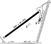
| Runways: | 04/22 |
| Longest Runway: | 04/22 is 2950 ft (899 m) long |
| Runways with an Instrument Approach: |
1U2 Airport Runway Details
| Runway 04/22 | 2950 ft x 40 ft (899 m x 12 m) | |
| Runway Length Source: | OWNER as of 09/09/2021 | |
| Surface: | Asphalt - Fair condition - No special surface treatment | |
| Runway Edge Lights: | Non-standard lighting system Intensity | |
Runway 04 |
Runway 22 |
|
Elevation: |
4795.0 | 4788.0 |
Latitude: |
43-50-53.7700N | 43-51-15.3400N |
Longitude: |
112-30-17.2300W | 112-29-50.1700W |
Glide Path Angle: |
0.0 degrees | 0.0 degrees |
Runway Markings Type: |
Basic | Basic |
Runway Markings Condition: |
Fair | Fair |
Object at End: |
FENCE | ROAD |
Object Height: |
5 | 12 |
Distance from End: |
290 | 300 |
Object Centerline Offset: |
0 ft. left and right of centerline | 150 ft. left of centerline |
Services
Airframe Repair: |
Major |
Powerplant Repair: |
Major |
Bottled Oxygen: |
None |
Bulk Oxygen: |
Low Pressure |
Fuel Available: |
100LL, Jet A |
Landing Fees: |
Yes |
Parking: |
Hangars and tiedowns available |
Maps & Diagrams
1U2 Sectional
Flight Planning
at skyvector.com
at skyvector.com