Location
Latitude: |
40-58-18.0750N (40.971688) |
Longitude: |
078-14-34.7250W (-78.242979) |
Elevation: |
1784.0 feet MSL (544 m MSL) |
Magnetic Variation: |
10.4 W (as of April 2024 from WMM2020 model) |
Time Zone: |
UTC -5.0 (Standard Time) UTC -4.0 (Daylight Savings Time) |
From City: |
05 N.M. N of Philipsburg, Pennsylvania |
Found On: |
Detroit Chart |
FAA Region: |
AEA |
Contacts
Manager: |
Privately owned: |
| JAMIE CONDON 2174 DEER CREEK RD MORRISDALE, PA 16858 (814) 553-4693 |
FRANK W ALBERT ESTATE 1945 DEER CREEK RD MORRISDALE, PA 16858 (814) 553-4693 |
Operations
Airport Status: |
Operational |
Facility Use: |
Public |
Type: |
Airport |
Activation Date: |
10/1943 |
Control tower: |
No |
Attendance (Months/Days/Hours): |
Months/Days/Hours Unattended |
Boundary ARTCC: |
ZOB (Cleveland) |
Responsible ARTCC: |
ZNY (New York) |
Segmented Circle Indicator: |
No |
Traffic Pattern Altitude (MSL): |
2784 feet (849 m) |
NOTAMs Facility: |
AOO |
NOTAM-D Service: |
Yes |
International Airport of Entry: |
No |
Customs Landing Rights: |
No |
Military Landing Rights: |
No |
Based Aircraft
| Ultralights: | 2 |
Annual Operations (as of 05/25/2023)
| Total Operations: | 160 | |
| GA Local: | 150 | 93.8% |
| GA Itinerant: | 10 | 6.2% |
Communications
| CTAF: | 122.900 |
Fixed Based Operators (FBOs) & Fuel
(Click on a business for detail)
Please help us keep this information up to date. This is a FREE SERVICE just like everything else on Airport Guide! If you see that a business needs to be added, modified, or deleted please fill out our Update Form.
To add, modify, or delete a business click here.
Please help us keep this information up to date. This is a FREE SERVICE just like everything else on Airport Guide! If you see that a business needs to be added, modified, or deleted please fill out our Update Form.
Area Code: 814 |
| Business Name | Frequency | Phone | Fuel Grade |
|---|
Flight Service Stations
| Primary | Alternate | |
| FSS on Field: | N | |
| FSS Name (ID): | Altoona(AOO) | |
| Frequency: | ||
| Toll Free Phone: | 1-800-WX-BRIEF |
Instrument Procedures / Charts
Terminal Procedures are only available for airports in several countries with more being added all the time. If you are looking for a specific country's charts, please send an email to support(at)airportguide.com stating the country name. This will be used to prioritize the implementation.
Navigation Aids (Navaids) near 1N3
| Dist (NM) | ID | Morse Code | Name | Type | Freq | True Hdg | Mag Hdg |
|---|---|---|---|---|---|---|---|
| 11.8 | PSB | . _ _ . . . . _ . . . | Philipsburg | VORTAC | 115.50 | 106 | 117 |
| 14.8 | TON | _ _ _ _ _ . | Tyrone | VORTAC | 114.90 | 195 | 205 |
| 15.3 | ETG | . _ _ _ . | Keating | VORTAC | 116.00 | 17 | 27 |
| 23.0 | UN | . . _ _ . | Penue | NDB | 388 | 99 | 110 |
| 34.3 | REC | . _ . . _ . _ . | Revloc | VOR-DME | 110.60 | 222 | 232 |
| 34.7 | SLT | . . . . _ . . _ | Slate Run | VORTAC | 113.90 | 20 | 31 |
| 38.9 | AOO | . _ _ _ _ _ _ _ | Altoona | VOR | 108.80 | 184 | 194 |
| 42.6 | INP | . . _ . . _ _ . | Indiana | NDB | 242 | 241 | 251 |
| 47.6 | JST | . _ _ _ . . . _ | Johnstown | VOR-DME | 113.00 | 214 | 224 |
| 51.7 | BFD | _ . . . . . _ . _ . . | Bradford | DME | 116.6 | 341 | 351 |
| 56.0 | CIP | _ . _ . . . . _ _ . | Clarion | DME | 112.9 | 281 | 291 |
| 57.1 | SFK | . . . . . _ . _ . _ | Stonyfork | VOR-DME | 108.60 | 40 | 51 |
| 58.9 | BHU | _ . . . . . . . . . _ | Benje | NDB | 382 | 232 | 242 |
| 61.4 | SYS | . . . _ . _ _ . . . | Stoystown | NDB | 209 | 210 | 220 |
| 62.6 | SEG | . . . . _ _ . | Selinsgrove | VOR-DME | 110.40 | 99 | 110 |
| 63.7 | THS | _ . . . . . . . | St Thomas | VORTAC | 115.00 | 167 | 177 |
| 66.8 | HAR | . . . . . _ . _ . | Harrisburg | VORTAC | 112.50 | 126 | 137 |
| 68.0 | ELZ | . . _ . . _ _ . . | Wellsville | DME | 115.85 | 9 | 20 |
| 69.1 | TDT | _ _ . . _ | Tidioute | DME | 117.6 | 310 | 320 |
| 69.9 | FQM | . . _ . _ _ . _ _ _ | Williamsport | VOR-DME | 114.40 | 71 | 82 |
Nearby Airports with Fuel
Notices to Airmen (NOTAMS)
Remarks
| A110-1 | ULTRALIGHT OPNS ON & INVOF ARPT. |
| A110-2 | BIRDS; DEER & GROUND HOGS ON & INVOF ARPT. |
| A110-3 | FOR CD CTC NEW YORK ARTCC AT 631-468-1425. |
| A17 | ARPT CLSD NOV-MAR ANNUALLY. |
| A33-11/29 | SHALE AND TURF. |
| A42-11 | RY EDGES MKD WITH YELLOW CONES. |
| A42-29 | RY EDGES MKD WITH YELLOW CONES. |
| A50-11 | DSPLCD THLD MKD WITH THREE YLW CONES. |
| A50-29 | DSPLCD THLD MKD WITH THREE YLW CONES. |
| A51-11 | RWY DTHR MKD WITH YELLOW CONES. |
| A51-29 | RWY DTHR MKD WITH YELLOW CONES. |
| A57-11 | APCH SLOPE 23:1 TO DSPLCD THLD. |
| A57-29 | APCH SLOPE 24:1 TO DSPLCD THLD. |
| E111 | VFR ONLY |
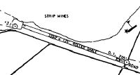
Runways
Runway Summary
| Runways: | 11/29 |
| Longest Runway: | 11/29 is 3350 ft (1021 m) long |
| Runways with an Instrument Approach: |
1N3 Airport Runway Details
| Runway 11/29 | 3350 ft x 125 ft (1021 m x 38 m) | |
| Surface: | Turf/Gravel - Fair condition - No special surface treatment | |
Runway 11 |
Runway 29 |
|
Elevation: |
1776.0 | 1760.0 |
Latitude: |
40-58-19.4900N | 40-58-16.6600N |
Longitude: |
078-14-56.4800W | 078-14-12.9700W |
Glide Path Angle: |
0.0 degrees | 0.0 degrees |
Traffic Pattern: |
Left | Left |
Object at End: |
TREES | ROAD |
Object Height: |
50 | 36 |
Distance from End: |
70 | 211 |
Object Centerline Offset: |
96 ft. right of centerline | 141 ft. left and right of centerline |
Displaced Threshold: |
750 | 200 |
Threshold Latitude: |
40-58-18.8568N | 40-58-16.8291N |
Threshold Longitude: |
078-14-46.7385W | 078-14-15.5677W |
Services
Airframe Repair: |
None |
Powerplant Repair: |
None |
Bottled Oxygen: |
None |
Bulk Oxygen: |
None |
Fuel Available: |
100LL, Jet A, Jet A+ |
Landing Fees: |
No |
Parking: |
Hangars and tiedowns available |
Maps & Diagrams
1N3 Sectional
Flight Planning
at skyvector.com
at skyvector.com