Location
Latitude: |
36-35-34.3000N (36.592861) |
Longitude: |
086-28-36.9000W (-86.476917) |
Elevation: |
817.2 feet MSL (249 m MSL) |
Magnetic Variation: |
4.4 W (as of April 2024 from WMM2020 model) |
Time Zone: |
UTC -6.0 (Standard Time) UTC -5.0 (Daylight Savings Time) |
From City: |
03 N.M. NE of Portland, Tennessee |
Found On: |
St Louis Chart |
FAA Region: |
ASO |
Contacts
Manager: |
Publicly owned: |
| DOUGLAS HUNTER 601 AIRPORT RD PORTLAND, TN 37148 615-323-7500 |
CITY OF PORTLAND 100 SOUTH RUSSELL ST. MOBILE, TN 37148 615-533-7210 |
Operations
Airport Status: |
Operational |
Facility Use: |
Public |
Type: |
Airport |
Activation Date: |
07/1944 |
Control tower: |
No |
Attendance (Months/Days/Hours): |
Months/Days/Hours MAR-OCT/ALL/0800-1700 |
Boundary ARTCC: |
ZME (Memphis) |
Responsible ARTCC: |
ZME (Memphis) |
Lighting Schedule: |
SEE RMK |
Segmented Circle Indicator: |
Yes |
Traffic Pattern Altitude (MSL): |
1817 feet (554 m) |
NOTAMs Facility: |
BNA |
NOTAM-D Service: |
Yes |
International Airport of Entry: |
No |
Customs Landing Rights: |
No |
Military Landing Rights: |
Yes |
Civil/Military Joint Use: |
No |
Based Aircraft
| Single Engine: | 19 |
| Multi Engine: | 2 |
| GA Helicopters: | 1 |
Annual Operations (as of 12/31/2017)
| Total Operations: | 12700 | |
| Air Taxi: | 200 | 1.6% |
| GA Local: | 6000 | 47.2% |
| GA Itinerant: | 6000 | 47.2% |
| Military Aircraft: | 500 | 3.9% |
Communications
| CTAF: | 122.975 |
| Unicom: | 122.975 |
| Approach: | NASHVILLE 119.35 119.35 |
| Departure: | NASHVILLE 119.35 119.35 |
| AWOS-3PT: | 118.175 (615-325-4971) |
Fixed Based Operators (FBOs) & Fuel
(Click on a business for detail)
Please help us keep this information up to date. This is a FREE SERVICE just like everything else on Airport Guide! If you see that a business needs to be added, modified, or deleted please fill out our Update Form.
To add, modify, or delete a business click here.
Please help us keep this information up to date. This is a FREE SERVICE just like everything else on Airport Guide! If you see that a business needs to be added, modified, or deleted please fill out our Update Form.
Area Code: 615 |
| Business Name | Frequency | Phone | Fuel Grade |
|---|
Flight Service Stations
| Primary | Alternate | |
| FSS on Field: | N | |
| FSS Name (ID): | Nashville(BNA) | |
| Frequency: | ||
| Toll Free Phone: | 1-800-WX-BRIEF |
Instrument Procedures / Charts
FAA Terminal Procedures valid from 0901Z 03/21/24 to 0901Z 04/18/24.
There are various types of charts available for an airport. They are listed in the Page Type column. Here is a legend for those types:
APD - Airport Diagram
DP - Departure Procedure Charts
HOT - Hot Spots
IAP - Instrument Approach Procedure Charts
MIN - Minimums
STAR - Standard Terminal Arrival Charts
| Page Type | Page Name | Volume | Action Since Last Cycle |
|---|---|---|---|
| IAP | RNAV (GPS) RWY 01 | SE-1 | |
| IAP | RNAV (GPS) RWY 19 | SE-1 | |
| MIN | ALTERNATE MINIMUMS | SE-1 | |
| MIN | TAKEOFF MINIMUMS | SE-1 |
Terminal Procedures are only available for airports in several countries with more being added all the time. If you are looking for a specific country's charts, please send an email to support(at)airportguide.com stating the country name. This will be used to prioritize the implementation.
Navigation Aids (Navaids) near 1M5
| Dist (NM) | ID | Morse Code | Name | Type | Freq | True Hdg | Mag Hdg |
|---|---|---|---|---|---|---|---|
| 17.2 | BW | _ . . . . _ _ | Noora | NDB | 236 | 359 | 363 |
| 20.2 | BWG | _ . . . . _ _ _ _ . | Bowling Green | DME | 117.9 | 4 | 8 |
| 24.8 | VI | . . . _ . . | Opery | NDB | 344 | 200 | 204 |
| 25.3 | JUE | . _ _ _ . . _ . | Lebanon | NDB | 414 | 161 | 165 |
| 25.7 | ON | _ _ _ _ . | Music | NDB | 279 | 252 | 256 |
| 29.1 | BNA | _ . . . _ . . _ | Nashville | VORTAC | 114.10 | 200 | 204 |
| 30.0 | BNA | _ . . . _ . . _ | Nashville Metropoln | VOT | 108.60 | 197 | 201 |
| 34.0 | BVQ | _ . . . . . . _ _ _ . _ | Beaver Creek | NDB | 260 | 41 | 46 |
| 35.2 | MQY | _ _ _ _ . _ _ . _ _ | Smyrna | VOT | 110.20 | 182 | 186 |
| 38.2 | SWZ | . . . . _ _ _ _ . . | Sewart | NDB | 391 | 179 | 183 |
| 38.2 | FQW | . . _ . _ _ . _ . _ _ | Walter Hill | NDB | 371 | 172 | 176 |
| 44.0 | CK | _ . _ . _ . _ | Snuff | NDB | 335 | 265 | 269 |
| 44.8 | HIX | . . . . . . _ . . _ | Honey Grove | NDB | 356 | 292 | 296 |
| 45.1 | CKV | _ . _ . _ . _ . . . _ | Clarksville | VOR-DME | 110.60 | 272 | 276 |
| 45.9 | FK | . . _ . _ . _ | Airbe | NDB | 273 | 281 | 285 |
| 48.8 | SKN | . . . _ . _ _ . | Hurricane | NDB | 256 | 138 | 143 |
| 50.0 | HXW | . . . . _ . . _ . _ _ | Screaming Eagle | TACAN | 114.90 | 274 | 278 |
| 50.2 | GMH | _ _ . _ _ . . . . | Muhlenberg | NDB | 362 | 319 | 323 |
| 54.0 | DMZ | _ . . _ _ _ _ . . | Dickson | NDB | 203 | 239 | 243 |
| 56.3 | HEM | . . . . . _ _ | Huchn | NDB | 233 | 129 | 134 |
Nearby Airports with Fuel
Notices to Airmen (NOTAMS)
Remarks
| A110*G | THIS AIRPORT HAS BEEN SURVEYED BY THE NATIONAL GEODETIC SURVEY. |
| A110-1 | FOR CD CTC NASHVILLE APCH AT 615-695-4524. |
| A16 | 615-533-7210. |
| A17 | CLSD FED HOL. |
| A81-APT | ACTVT MIRL RWY 01/19 - CTAF. PAPI RWY 01 & 19 ON CONSLY. |
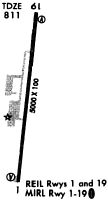
Runways
Runway Summary
| Runways: | 01/19 |
| Longest Runway: | 01/19 is 5000 ft (1524 m) long |
| Runways with an Instrument Approach: |
1M5 Airport Runway Details
| Runway 01/19 | 5000 ft x 100 ft (1524 m x 30 m) | |
| Runway Length Source: | NGS as of 04/16/2009 | |
| Surface: | Asphalt - Fair condition - No special surface treatment | |
| Runway Pavement Class: | 13 /F/C/X/T | |
| Runway Edge Lights: | Medium Intensity | |
Runway Weight Bearing Capacity (in thousands of pounds) |
||
| Single Wheel Landing Gear: | 30.0 | |
| Dual Wheel Landing Gear: | 50.0 | |
Runway 01 |
Runway 19 |
|
Elevation: |
817.2 | 770.0 |
Latitude: |
36-35-10.0554N | 36-35-58.5757N |
Longitude: |
086-28-42.7779W | 086-28-30.9842W |
|
Runway True Alignment: |
011 | 191 |
Glide Path Angle: |
3.5 degrees | 3.0 degrees |
Traffic Pattern: |
Left | Left |
Runway Markings Type: |
Nonprecision Instrument | Nonprecision Instrument |
Runway Markings Condition: |
Fair | Fair |
Object at End: |
TREE | |
Object Height: |
84 | |
Distance from End: |
1840 | |
Object Centerline Offset: |
344 ft. right of centerline | |
Visual Glide Slope Indicators: |
4-Light PAPI On Right Side Of Runway | 4-Light PAPI On Right Side Of Runway |
REIL: |
Yes | Yes |
Threshold Crossing Height: |
21 |
Services
Airframe Repair: |
Major |
Powerplant Repair: |
Major |
Fuel Available: |
100LL, Jet A+ |
Landing Fees: |
No |
Parking: |
Hangars and tiedowns available |
Maps & Diagrams
1M5 Sectional
Flight Planning
at skyvector.com
at skyvector.com