Location
Latitude: |
43-15-16.3000N (43.254528) |
Longitude: |
073-28-12.7000W (-73.470194) |
Elevation: |
330.0 feet MSL (101 m MSL) |
Magnetic Variation: |
13.3 W (as of April 2024 from WMM2020 model) |
Time Zone: |
UTC -5.0 (Standard Time) UTC -4.0 (Daylight Savings Time) |
From City: |
02 N.M. NE of Argyle, New York |
Found On: |
New York Chart |
FAA Region: |
AEA |
Contacts
Manager: |
Privately owned: |
| GENE FEHER 5292 STATE ROUTE 40 ARGYLE, NY 12809 518-638-9723 |
ARGYLE AIRPORT HOLDINGS, LLC 5292 STATE ROUTE 40 ARGYLE, NY 12809 518-638-9723 |
Operations
Airport Status: |
Operational |
Facility Use: |
Public |
Type: |
Airport |
Activation Date: |
11/1974 |
Control tower: |
No |
Attendance (Months/Days/Hours): |
Months/Days/Hours ALL/ALL/0900-DUSK |
Boundary ARTCC: |
ZBW (Boston) |
Responsible ARTCC: |
ZBW (Boston) |
Segmented Circle Indicator: |
No |
Traffic Pattern Altitude (MSL): |
1330 feet (405 m) |
NOTAMs Facility: |
BTV |
NOTAM-D Service: |
Yes |
Based Aircraft
| Single Engine: | 27 |
| Ultralights: | 1 |
Annual Operations (as of 06/19/2018)
| Total Operations: | 20000 | |
| GA Local: | 17000 | 85.0% |
| GA Itinerant: | 2000 | 10.0% |
| Military Aircraft: | 1000 | 5.0% |
Communications
| CTAF: | 122.900 |
Fixed Based Operators (FBOs) & Fuel
(Click on a business for detail)
Please help us keep this information up to date. This is a FREE SERVICE just like everything else on Airport Guide! If you see that a business needs to be added, modified, or deleted please fill out our Update Form.
To add, modify, or delete a business click here.
Please help us keep this information up to date. This is a FREE SERVICE just like everything else on Airport Guide! If you see that a business needs to be added, modified, or deleted please fill out our Update Form.
Area Code: 518 |
| Business Name | Frequency | Phone | Fuel Grade |
|---|
Flight Service Stations
| Primary | Alternate | |
| FSS on Field: | N | |
| FSS Name (ID): | Burlington(BTV) | |
| Frequency: | ||
| Toll Free Phone: | 1-800-WX-BRIEF |
Instrument Procedures / Charts
Terminal Procedures are only available for airports in several countries with more being added all the time. If you are looking for a specific country's charts, please send an email to support(at)airportguide.com stating the country name. This will be used to prioritize the implementation.
Navigation Aids (Navaids) near 1C3
| Dist (NM) | ID | Morse Code | Name | Type | Freq | True Hdg | Mag Hdg |
|---|---|---|---|---|---|---|---|
| 5.9 | GF | _ _ . . . _ . | Ganse | NDB | 209 | 270 | 283 |
| 8.1 | GFL | _ _ . . . _ . . _ . . | Glens Falls | VORTAC | 110.20 | 310 | 323 |
| 16.6 | CAM | _ . _ . . _ _ _ | Cambridge | VOR-DME | 115.00 | 160 | 173 |
| 27.9 | RUT | . _ . . . _ _ | Rutland | DME | 111 | 54 | 67 |
| 31.5 | HEU | . . . . . . . _ | Hunter | NDB | 356 | 220 | 233 |
| 32.1 | R | . _ . | Chitt | FAN MARKER | 44 | 58 | |
| 33.0 | VWD | . . . _ . _ _ _ . . | Mount Snow | NDB | 224 | 126 | 139 |
| 33.8 | ALB | . _ . _ . . _ . . . | Albany | VORTAC | 115.30 | 205 | 218 |
| 34.4 | ALB | . _ . _ . . _ . . . | Albany | VOT | 108.20 | 206 | 219 |
| 35.1 | DYO | _ . . _ . _ _ _ _ _ | Smuto | NDB | 221 | 39 | 53 |
| 38.6 | SXD | . . . _ . . _ _ . . | Springfield | NDB | 265 | 88 | 102 |
| 40.7 | JJH | . _ _ _ . _ _ _ . . . . | Johnstown | NDB | 523 | 248 | 261 |
| 47.5 | IVV | . . . . . _ . . . _ | White River | NDB | 379 | 66 | 80 |
| 48.5 | CNH | _ . _ . _ . . . . . | Claremont | NDB | 233 | 81 | 95 |
| 58.6 | EEN | . . _ . | Keene | DME | 109.4 | 117 | 131 |
| 60.3 | LEB | . _ . . . _ . . . | Lebanon | DME | 113.7 | 64 | 78 |
| 61.1 | PFH | . _ _ . . . _ . . . . . | Philmont | NDB | 272 | 190 | 203 |
| 62.2 | CTR | _ . _ . _ . _ . | Chester | VOR-DME | 115.10 | 158 | 171 |
| 62.4 | LAH | . _ . . . _ . . . . | Hanover | NDB | 276 | 64 | 78 |
| 64.4 | GBR | _ _ . _ . . . . _ . | Great Barrington | NDB | 395 | 177 | 190 |
Nearby Airports with Fuel
Notices to Airmen (NOTAMS)
Remarks
| A110-1 | ULTRALGTS ON & INVOF ARPT. |
| A110-3 | ARPT MAY BE CLSD WET WX CALL 518-638-9723. |
| A110-4 | FOR CD CTC ALBANY APCH AT 518-862-2299. |
| A110-5 | RWY GENERALLY PLOWED DRG WINTER BUT MAY BE SNOWY/ICY. CHECK/INSPECT BFR TAKING OFF OR LNDG AND USE AT YOUR DISCRETION. |
| A110-6 | BIRDS & WILDLIFE MAY BE ON OR INVOF ARPT. |
| A110-7 | MOWING OR PLOWING MAY OCCUR DURG DALGT HRS; CTAF MNTD. |
| A32-03/21 | WIDTH VARIES FROM 87'-100' |
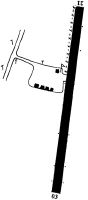
Runways
Runway Summary
| Runways: | 03/21 |
| Longest Runway: | 03/21 is 2400 ft (732 m) long |
| Runways with an Instrument Approach: |
1C3 Airport Runway Details
| Runway 03/21 | 2400 ft x 87 ft (732 m x 27 m) | |
| Surface: | Turf - Excellent condition - No special surface treatment | |
Runway 03 |
Runway 21 |
|
Elevation: |
310.0 | 314.0 |
Latitude: |
43-15-04.8463N | 43-15-27.7790N |
Longitude: |
073-28-16.8353W | 073-28-08.5967W |
|
Runway True Alignment: |
015 | 195 |
Glide Path Angle: |
0.0 degrees | 0.0 degrees |
Traffic Pattern: |
Left | Left |
Object at End: |
TREE | TREE |
Object Height: |
40 | 81 |
Distance from End: |
8 | 185 |
Object Centerline Offset: |
115 ft. right of centerline | 255 ft. right of centerline |
Services
Airframe Repair: |
Major |
Powerplant Repair: |
Minor |
Bottled Oxygen: |
High Pressure |
Bulk Oxygen: |
High Pressure |
Fuel Available: |
100, 100LL, Jet A-1+ |
Landing Fees: |
No |
Parking: |
Hangars and tiedowns available |
Maps & Diagrams
1C3 Sectional
Flight Planning
at skyvector.com
at skyvector.com