Location
Latitude: |
41-01-41.4650N (41.028185) |
Longitude: |
081-47-53.3300W (-81.798147) |
Elevation: |
1210.0 feet MSL (369 m MSL) |
Magnetic Variation: |
8.2 W (as of April 2024 from WMM2020 model) |
Time Zone: |
UTC -5.0 (Standard Time) UTC -4.0 (Daylight Savings Time) |
From City: |
03 N.M. W of Wadsworth, Ohio |
Found On: |
Detroit Chart |
FAA Region: |
AGL |
Contacts
Manager: |
Privately owned: |
| JOEL KULL 3071 GREENWICH RD WADSWORTH, OH 44281-9516 330-573-6437 |
JOEL KULL 3071 GREENWICH RD WADSWORTH, OH 44281-9516 330-573-6437 |
Operations
Airport Status: |
Operational |
Facility Use: |
Public |
Type: |
Airport |
Activation Date: |
07/1967 |
Control tower: |
No |
Attendance (Months/Days/Hours): |
Months/Days/Hours ALL/ALL/DAWN TO DUSK |
Boundary ARTCC: |
ZOB (Cleveland) |
Responsible ARTCC: |
ZOB (Cleveland) |
Lighting Schedule: |
SEE RMK |
Segmented Circle Indicator: |
No |
Traffic Pattern Altitude (MSL): |
2210 feet (674 m) |
NOTAMs Facility: |
CLE |
NOTAM-D Service: |
Yes |
International Airport of Entry: |
No |
Customs Landing Rights: |
No |
Military Landing Rights: |
No |
Civil/Military Joint Use: |
No |
Based Aircraft
| Single Engine: | 105 |
| Multi Engine: | 2 |
Annual Operations (as of 07/21/2020)
| Total Operations: | 74650 | |
| Air Taxi: | 100 | 0.1% |
| GA Local: | 70000 | 93.8% |
| GA Itinerant: | 4500 | 6.0% |
| Military Aircraft: | 50 | 0.1% |
Communications
| CTAF: | 123.050 |
| Unicom: | 123.050 |
Fixed Based Operators (FBOs) & Fuel
(Click on a business for detail)
Please help us keep this information up to date. This is a FREE SERVICE just like everything else on Airport Guide! If you see that a business needs to be added, modified, or deleted please fill out our Update Form.
To add, modify, or delete a business click here.
Please help us keep this information up to date. This is a FREE SERVICE just like everything else on Airport Guide! If you see that a business needs to be added, modified, or deleted please fill out our Update Form.
Area Code: 330 |
| Business Name | Frequency | Phone | Fuel Grade |
|---|---|---|---|
| Aero Dynamics, Inc.
Update FBO info |
Unicom 123.0 | 334-5337 | |
| Skypark, Inc.
Update FBO info |
334-9921 | 80, 100LL |
Flight Service Stations
| Primary | Alternate | |
| FSS on Field: | N | |
| FSS Name (ID): | Cleveland(CLE) | |
| Frequency: | ||
| Toll Free Phone: | 1-800-WX-BRIEF |
Instrument Procedures / Charts
Terminal Procedures are only available for airports in several countries with more being added all the time. If you are looking for a specific country's charts, please send an email to support(at)airportguide.com stating the country name. This will be used to prioritize the implementation.
Navigation Aids (Navaids) near 15G
| Dist (NM) | ID | Morse Code | Name | Type | Freq | True Hdg | Mag Hdg |
|---|---|---|---|---|---|---|---|
| 17.5 | CAK | _ . _ . . _ _ . _ | Akron/Canton Regional | VOT | 110.60 | 112 | 120 |
| 18.8 | AK | . _ _ . _ | Akron | NDB | 362 | 82 | 90 |
| 21.0 | AAU | . _ . _ . . _ | Ashland | NDB | 329 | 259 | 267 |
| 23.6 | CLE | _ . _ . . _ . . . | Cleveland | VOT | 110.40 | 354 | 362 |
| 23.9 | BSV | _ . . . . . . . . . _ | Briggs | VOR-DME | 112.40 | 135 | 143 |
| 25.7 | DJB | _ . . . _ _ _ _ . . . | Dryer | VOR-DME | 113.60 | 320 | 328 |
| 27.4 | ACO | . _ _ . _ . _ _ _ | Akron | VOR-DME | 114.40 | 79 | 87 |
| 29.4 | MLR | _ _ . _ . . . _ . | Millersburg/Dcmsnd | NDB | 382 | 186 | 194 |
| 33.3 | MF | _ _ . . _ . | Manns | NDB | 372 | 242 | 250 |
| 37.2 | MFD | _ _ . . _ . _ . . | Mansfield | VORTAC | 108.80 | 255 | 263 |
| 41.0 | CXR | _ . _ . _ . . _ . _ . | Chardon | VOR-DME | 112.70 | 44 | 52 |
| 43.6 | LQL | . _ . . _ _ . _ . _ . . | Lakeland | NDB | 263 | 25 | 33 |
| 45.7 | SKY | . . . _ . _ _ . _ _ | Sandusky | VOR-DME | 109.20 | 302 | 310 |
| 50.1 | CTW | _ . _ . _ . _ _ | Newcomerstown | DME | 111.8 | 162 | 170 |
| 53.9 | YNG | _ . _ _ _ . _ _ . | Youngstown | VORTAC | 109.00 | 69 | 78 |
| 55.3 | YN | _ . _ _ _ . | Fetch | NDB | 338 | 78 | 87 |
| 56.5 | PCW | . _ _ . _ . _ . . _ _ | Port Clinton | NDB | 423 | 301 | 309 |
| 57.8 | HBD | . . . . _ . . . _ . . | Hubbard | NDB | 408 | 82 | 91 |
| 59.4 | CFX | _ . _ . . . _ . _ . . _ | Cadiz | NDB | 239 | 142 | 150 |
| 62.5 | BUD | _ . . . . . _ _ . . | Buckeye | VOR | 109.80 | 247 | 255 |
Nearby Airports with Fuel
Notices to Airmen (NOTAMS)
Remarks
| A110-1 | RWY 03/21 TGL NA. |
| A110-2 | BIRDS & WILDLIFE ON & INVOF ARPT. |
| A110-3 | FOR CD CTC CLEVELAND APCH AT 216-352-2323. |
| A35-03/21 | LTD TO 6500 LBS PER AMGR. |
| A40-03/21 | NSTD LIRL DUE TO INCOR COLORS & MOUNTING ON 6 IN PVC PIPE. |
| A42-03 | FADED. |
| A42-21 | FADED. |
| A57-03 | APCH RATIO 0:1 AT DTHR DUE TO OVR 25 FT HNGR, 0 FT DIST, 100 FT L. |
| A57-21 | OBST CLNC SLOPE 0:1 AT DTHR OVR 20 FT TREES, 0 FT DIST, 45 FT L. |
| A58-03 | 15 FT ROAD, 0 FT DIST, 55 FT R; +8 FT SIGN, 85 FT L; 23 FT PLINE, 105 FT L/R. |
| A58-21 | 35 FT TREES AT RWY END; 15 FT BRUSH & TREES; 1 FT GUARD RAIL ACRS RWY END. |
| A81-APT | ACTVT NSTD LIRL RWY 03/21 - CTAF. |
| E111 | VFR ONLY. |
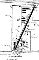
Runways
Runway Summary
| Runways: | 03/21 |
| Longest Runway: | 03/21 is 2410 ft (735 m) long |
| Runways with an Instrument Approach: |
15G Airport Runway Details
| Runway 03/21 | 2410 ft x 37 ft (735 m x 11 m) | |
| Surface: | Asphalt - Fair condition - No special surface treatment | |
| Runway Edge Lights: | Non-standard lighting system Intensity | |
Runway 03 |
Runway 21 |
|
Elevation: |
1210.0 | 1210.0 |
Latitude: |
41-01-30.6400N | 41-01-52.2900N |
Longitude: |
081-47-59.8700W | 081-47-46.7900W |
|
Runway True Alignment: |
025 | 205 |
Glide Path Angle: |
0.0 degrees | 0.0 degrees |
Traffic Pattern: |
Left | Left |
Runway Markings Type: |
Basic | Basic |
Runway Markings Condition: |
Poor | Poor |
Object at End: |
CROPS | TREES |
Object Height: |
8 | 80 |
Distance from End: |
201 | 395 |
Object Centerline Offset: |
0 ft. left and right of centerline | 145 ft. right of centerline |
Visual Glide Slope Indicators: |
Pulsating/Steady Burning VASI On Left Side Of Runway | Pulsating/Steady Burning VASI On Left Side Of Runway |
REIL: |
No | No |
Touchdown Lights: |
No | No |
Centerline Lights: |
No | No |
Displaced Threshold: |
178 | 50 |
Threshold Latitude: |
41-01-32.2393N | 41-01-51.8408N |
Threshold Longitude: |
081-47-58.9039W | 081-47-47.0614W |
Services
Airframe Repair: |
Major |
Powerplant Repair: |
Major |
Bottled Oxygen: |
None |
Bulk Oxygen: |
None |
Fuel Available: |
100LL, Jet A |
Landing Fees: |
No |
Parking: |
Hangars and tiedowns available |
Maps & Diagrams
15G Sectional
Flight Planning
at skyvector.com
at skyvector.com