Location
Latitude: |
33-11-29.3527N (33.191487) |
Longitude: |
099-43-04.3415W (-99.717873) |
Elevation: |
1625.4 feet MSL (495 m MSL) |
Magnetic Variation: |
4.4 E (as of April 2024 from WMM2020 model) |
Time Zone: |
UTC -6.0 (Standard Time) UTC -5.0 (Daylight Savings Time) |
From City: |
02 N.M. N of Haskell, Texas |
Found On: |
Dallas-Ft Worth Chart |
FAA Region: |
ASW |
Contacts
Manager: |
Publicly owned: |
| MATT USSERY 301 SOUTH 1ST STRET HASKELL, TX 79521 (940) 864-2333 |
CITY OF HASKELL CITY HALL PO BOX 1003 HASKELL, TX 79521 940-864-2333 |
Operations
Airport Status: |
Operational |
Facility Use: |
Public |
Type: |
Airport |
Activation Date: |
03/1971 |
Control tower: |
No |
Attendance (Months/Days/Hours): |
Months/Days/Hours Unattended |
Boundary ARTCC: |
ZFW (Fort Worth) |
Responsible ARTCC: |
ZFW (Fort Worth) |
Lighting Schedule: |
SEE RMK |
Segmented Circle Indicator: |
Yes |
Traffic Pattern Altitude (MSL): |
2625 feet (800 m) |
NOTAMs Facility: |
FTW |
NOTAM-D Service: |
Yes |
International Airport of Entry: |
No |
Customs Landing Rights: |
No |
Military Landing Rights: |
Yes |
Civil/Military Joint Use: |
No |
Based Aircraft
| Single Engine: | 5 |
Annual Operations (as of 11/14/2023)
| Total Operations: | 1500 | |
| GA Local: | 1000 | 66.7% |
| GA Itinerant: | 500 | 33.3% |
Communications
| CTAF: | 122.900 |
- APCH/DEP CTL SVC PRVDD BY FORT WORTH ARTCC (ZFW) ON FREQS 133.5/350.35 (WICHITA FALLS NR 2 RCAG).
Fixed Based Operators (FBOs) & Fuel
(Click on a business for detail)
Please help us keep this information up to date. This is a FREE SERVICE just like everything else on Airport Guide! If you see that a business needs to be added, modified, or deleted please fill out our Update Form.
To add, modify, or delete a business click here.
Please help us keep this information up to date. This is a FREE SERVICE just like everything else on Airport Guide! If you see that a business needs to be added, modified, or deleted please fill out our Update Form.
Area Code: 940 |
| Business Name | Frequency | Phone | Fuel Grade |
|---|---|---|---|
| City of Haskell
Update FBO info |
864-2333 | 100LL |
Flight Service Stations
| Primary | Alternate | |
| FSS on Field: | N | |
| FSS Name (ID): | Fort Worth(FTW) | |
| Frequency: | ||
| Toll Free Phone: | 1-800-WX-BRIEF |
Instrument Procedures / Charts
FAA Terminal Procedures valid from 0901Z 03/21/24 to 0901Z 04/18/24.
There are various types of charts available for an airport. They are listed in the Page Type column. Here is a legend for those types:
APD - Airport Diagram
DP - Departure Procedure Charts
HOT - Hot Spots
IAP - Instrument Approach Procedure Charts
MIN - Minimums
STAR - Standard Terminal Arrival Charts
| Page Type | Page Name | Volume | Action Since Last Cycle |
|---|---|---|---|
| IAP | RNAV (GPS)-A | SC-2 | |
| MIN | TAKEOFF MINIMUMS | SC-2 |
Terminal Procedures are only available for airports in several countries with more being added all the time. If you are looking for a specific country's charts, please send an email to support(at)airportguide.com stating the country name. This will be used to prioritize the implementation.
Navigation Aids (Navaids) near 15F
| Dist (NM) | ID | Morse Code | Name | Type | Freq | True Hdg | Mag Hdg |
|---|---|---|---|---|---|---|---|
| 0.1 | AKL | . _ _ . _ . _ . . | Haskell | NDB | 407 | 257 | 253 |
| 43.2 | ABI | . _ _ . . . . . | Abilene | VORTAC | 113.70 | 189 | 185 |
| 46.9 | GTH | _ _ . _ . . . . | Guthrie | DME | 114.5 | 318 | 313 |
| 46.9 | DYS | _ . . _ . _ _ . . . | Dyess | TACAN | 133.60 | 188 | 184 |
| 53.6 | AB | . _ _ . . . | Tomhi | NDB | 353 | 177 | 173 |
| 57.6 | TQA | _ _ _ . _ . _ | Tuscola | VOR-DME | 111.60 | 185 | 181 |
| 57.8 | SWW | . . . . _ _ . _ _ | Sweetwater | NDB | 275 | 220 | 215 |
| 61.3 | GHX | _ _ . . . . . _ . . _ | Graham | NDB | 371 | 91 | 87 |
| 66.0 | OIP | _ _ _ . . . _ _ . | Old Rip | NDB | 410 | 135 | 131 |
| 68.5 | SDR | . . . _ . . . _ . | Snyder | NDB | 359 | 244 | 239 |
| 71.0 | SKB | . . . _ . _ _ . . . | Scotland | NDB | 344 | 59 | 55 |
| 73.7 | SPS | . . . . _ _ . . . . | Wichita Falls | VORTAC | 112.70 | 49 | 45 |
| 76.2 | CDS | _ . _ . _ . . . . . | Childress | VORTAC | 117.00 | 338 | 333 |
| 76.5 | ICF | . . _ . _ . . . _ . | Madison | NDB | 296 | 55 | 51 |
| 77.7 | SHP | . . . . . . . . _ _ . | Sheppard | TACAN | 110.80 | 51 | 47 |
| 80.5 | CZX | _ . _ . _ _ . . _ . . _ | Crosbyton | NDB | 332 | 289 | 284 |
| 86.9 | BWD | _ . . . . _ _ _ . . | Brownwood | VOR-DME | 113.55 | 153 | 149 |
| 91.0 | MQP | _ _ _ _ . _ . _ _ . | Millsap | VORTAC | 117.70 | 107 | 103 |
| 91.0 | LTS | . _ . . _ . . . | Altus | VORTAC | 109.80 | 14 | 10 |
| 91.6 | UBC | . . _ _ . . . _ . _ . | Ballinger | NDB | 239 | 188 | 184 |
Nearby Airports with Fuel
Notices to Airmen (NOTAMS)
Remarks
| A110*G | THIS AIRPORT HAS BEEN SURVEYED BY THE NATIONAL GEODETIC SURVEY. |
| A110-1 | NO LINE OF SIGHT BETWEEN RY ENDS. |
| A110-2 | FOR CD CTC FORT WORTH ARTCC AT 817-858-7584. |
| A14 | PUBLIC WORKS DIRECTOR. |
| A33-18/36 | NMRS CRACKS, SPALLING, LOOSE STONES, VEGETATION GROWING. |
| A42-18 | MKG POOR. |
| A42-36 | MKG POOR. |
| A57-18 | APCH SLOPE 17:1 TO DSPLCD THLD. |
| A58-36 | 4 FT PIPE 174 FT DSTC, 49 FT. L |
| A70-FUEL-10 | 0LL FOR FUEL WKDAYS 0800-1700 CALL 940-207-1855; NIGHTS & WKENDS CALL 940-864-2345. |
| A81-APT | ACTVT MIRL RWY 18/36 - 122.8. NMRS LTS OUT, OBSCURED BY VEGETATION. |
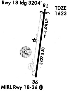
Runways
Runway Summary
| Runways: | 18/36 |
| Longest Runway: | 18/36 is 3420 ft (1042 m) long |
| Runways with an Instrument Approach: |
15F Airport Runway Details
| Runway 18/36 | 3420 ft x 50 ft (1042 m x 15 m) | |
| Runway Length Source: | NGS as of 11/19/1997 | |
| Surface: | Asphalt - Failed condition - No special surface treatment | |
| Runway Edge Lights: | Medium Intensity | |
Runway Weight Bearing Capacity (in thousands of pounds) |
||
| Single Wheel Landing Gear: | 13.0 | |
Runway 18 |
Runway 36 |
|
Elevation: |
1589.3 | 1625.4 |
Latitude: |
33-11-46.1129N | 33-11-12.5925N |
Longitude: |
099-43-01.6078W | 099-43-07.0749W |
|
Runway True Alignment: |
188 | 008 |
Glide Path Angle: |
0.0 degrees | 0.0 degrees |
Traffic Pattern: |
Left | Left |
Runway Markings Type: |
Nonprecision Instrument | Nonprecision Instrument |
Runway Markings Condition: |
Poor | Poor |
Object at End: |
PLINE | ROAD |
Object Height: |
35 | 15 |
Distance from End: |
600 | 416 |
Object Centerline Offset: |
325 ft. right of centerline | 0 ft. left and right of centerline |
Threshold Elevation: |
1591.9 | |
Displaced Threshold: |
206 | |
Threshold Latitude: |
33-11-44.0896N | |
Threshold Longitude: |
099-43-01.9378W |
Services
Fuel Available: |
100LL |
Landing Fees: |
No |
Parking: |
Tiedowns available |
Maps & Diagrams
15F Sectional
Flight Planning
at skyvector.com
at skyvector.com