Location
Latitude: |
40-32-12.1245N (40.536701) |
Longitude: |
081-57-21.3882W (-81.955941) |
Elevation: |
1226.5 feet MSL (374 m MSL) |
Magnetic Variation: |
8 W (as of April 2024 from WMM2020 model) |
Time Zone: |
UTC -5.0 (Standard Time) UTC -4.0 (Daylight Savings Time) |
From City: |
02 N.M. SW of Millersburg, Ohio |
Found On: |
Detroit Chart |
FAA Region: |
AGL |
Contacts
Manager: |
Publicly owned: |
| LARRY CLARK 4501 TOWNSHIP ROAD 307 MILLERSBURG, OH 44654-9656 330-674-0674 |
HOLMES CO ARPT AUTH 10 S CLAY ST MILLERSBURG, OH 44654-1329 330-674-8625 |
Operations
Airport Status: |
Operational |
Facility Use: |
Public |
Type: |
Airport |
Activation Date: |
03/1962 |
Control tower: |
No |
Attendance (Months/Days/Hours): |
Months/Days/Hours ALL/MON-FRI/0800-1700 |
Boundary ARTCC: |
ZID (Indianapolis) |
Responsible ARTCC: |
ZID (Indianapolis) |
Lighting Schedule: |
SEE RMK |
Segmented Circle Indicator: |
No |
Traffic Pattern Altitude (MSL): |
2226 feet (678 m) |
NOTAMs Facility: |
CLE |
NOTAM-D Service: |
Yes |
International Airport of Entry: |
No |
Customs Landing Rights: |
No |
Military Landing Rights: |
Yes |
Civil/Military Joint Use: |
No |
Based Aircraft
| Single Engine: | 16 |
| Multi Engine: | 1 |
| Jet Engine: | 1 |
Annual Operations (as of 09/07/2022)
| Total Operations: | 21500 | |
| Air Taxi: | 500 | 2.3% |
| GA Local: | 15000 | 69.8% |
| GA Itinerant: | 5000 | 23.3% |
| Military Aircraft: | 1000 | 4.7% |
Communications
| CTAF: | 123.000 |
| Unicom: | 123.000 |
| AWOS-3: | 128.325 (330-674-6279) |
- APCH/DEP SVC PRVDD BY INDIANAPOLIS ARTCC ON FREQS 124.45/323.275 (ZANESVILLE RCAG).
Fixed Based Operators (FBOs) & Fuel
(Click on a business for detail)
Please help us keep this information up to date. This is a FREE SERVICE just like everything else on Airport Guide! If you see that a business needs to be added, modified, or deleted please fill out our Update Form.
To add, modify, or delete a business click here.
Please help us keep this information up to date. This is a FREE SERVICE just like everything else on Airport Guide! If you see that a business needs to be added, modified, or deleted please fill out our Update Form.
Area Code: 330 |
| Business Name | Frequency | Phone | Fuel Grade |
|---|---|---|---|
| Holmes County Aviation, Inc.
Update FBO info |
Unicom 123.0 | 674-2686 | 100LL, Jet A |
Flight Service Stations
| Primary | Alternate | |
| FSS on Field: | N | |
| FSS Name (ID): | Cleveland(CLE) | |
| Frequency: | ||
| Toll Free Phone: | 1-800-WX-BRIEF |
Instrument Procedures / Charts
FAA Terminal Procedures valid from 0901Z 03/21/24 to 0901Z 04/18/24.
There are various types of charts available for an airport. They are listed in the Page Type column. Here is a legend for those types:
APD - Airport Diagram
DP - Departure Procedure Charts
HOT - Hot Spots
IAP - Instrument Approach Procedure Charts
MIN - Minimums
STAR - Standard Terminal Arrival Charts
| Page Type | Page Name | Volume | Action Since Last Cycle |
|---|---|---|---|
| IAP | RNAV (GPS) RWY 09 | EC-2 | |
| IAP | RNAV (GPS) RWY 27 | EC-2 | |
| MIN | ALTERNATE MINIMUMS | EC-2 | |
| MIN | TAKEOFF MINIMUMS | EC-2 |
Terminal Procedures are only available for airports in several countries with more being added all the time. If you are looking for a specific country's charts, please send an email to support(at)airportguide.com stating the country name. This will be used to prioritize the implementation.
Navigation Aids (Navaids) near 10G
| Dist (NM) | ID | Morse Code | Name | Type | Freq | True Hdg | Mag Hdg |
|---|---|---|---|---|---|---|---|
| 3.8 | MLR | _ _ . _ . . . _ . | Millersburg/Dcmsnd | NDB | 382 | 85 | 93 |
| 26.2 | MF | _ _ . . _ . | Manns | NDB | 372 | 301 | 309 |
| 26.8 | BSV | _ . . . . . . . . . _ | Briggs | VOR-DME | 112.40 | 62 | 70 |
| 28.6 | CTW | _ . _ . _ . _ _ | Newcomerstown | DME | 111.8 | 129 | 137 |
| 28.9 | AAU | . _ . _ . . _ | Ashland | NDB | 329 | 332 | 340 |
| 32.6 | CAK | _ . _ . . _ _ . _ | Akron/Canton Regional | VOT | 110.60 | 45 | 53 |
| 35.1 | MFD | _ _ . . _ . _ . . | Mansfield | VORTAC | 108.80 | 304 | 312 |
| 35.9 | ZZV | _ _ . . _ _ . . . . . _ | Zanesville | VOR-DME | 114.95 | 175 | 183 |
| 37.0 | APE | . _ . _ _ . . | Appleton | VORTAC | 116.70 | 231 | 239 |
| 37.9 | HRA | . . . . . _ . . _ | Zanesville | NDB | 204 | 177 | 185 |
| 38.5 | HEH | . . . . . . . . . | Newark | NDB | 524 | 217 | 225 |
| 41.1 | AK | . _ _ . _ | Akron | NDB | 362 | 38 | 46 |
| 46.7 | CFX | _ . _ . . . _ . _ . . _ | Cadiz | NDB | 239 | 112 | 120 |
| 48.5 | ACO | . _ _ . _ . _ _ _ | Akron | VOR-DME | 114.40 | 44 | 52 |
| 49.3 | CM | _ . _ . _ _ | Sumie | NDB | 391 | 228 | 236 |
| 50.2 | DJB | _ . . . _ _ _ _ . . . | Dryer | VOR-DME | 113.60 | 349 | 357 |
| 50.7 | BUD | _ . . . . . _ _ . . | Buckeye | VOR | 109.80 | 275 | 283 |
| 53.2 | CLE | _ . _ . . _ . . . | Cleveland | VOT | 110.40 | 5 | 13 |
| 53.6 | CMH | _ . _ . _ _ . . . . | Port Columbus | VOT | 111.00 | 232 | 240 |
| 56.3 | LC | . _ . . _ . _ . | Pickl | NDB | 376 | 225 | 233 |
Nearby Airports with Fuel
Notices to Airmen (NOTAMS)
Remarks
| A110-1 | DEER ON & INVOF ARPT. |
| A110-2 | FOR CD CTC INDIANAPOLIS ARTCC AT 317-247-2411. |
| A16 | CELL 330-231-3715. |
| A17 | UNATNDD MAJ HOLS. |
| A75 | PPR. |
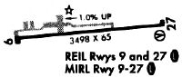
| A81-APT | ACTVT MIRL RY 09/27, PAPI RY 27 AND REIL RYS 09 & 27 - 123.4. |
Runways
Runway Summary
| Runways: | 09/27 |
| Longest Runway: | 09/27 is 4400 ft (1341 m) long |
| Runways with an Instrument Approach: |
10G Airport Runway Details
| Runway 09/27 | 4400 ft x 75 ft (1341 m x 23 m) | |
| Runway Length Source: | 3RD PARTY SURVEY as of 09/07/2011 | |
| Surface: | Asphalt - Fair condition - No special surface treatment | |
| Runway Edge Lights: | Medium Intensity | |
Runway Weight Bearing Capacity (in thousands of pounds) |
||
| Single Wheel Landing Gear: | 14.0 | |
| Dual Wheel Landing Gear: | 25.0 | |
Runway 09 |
Runway 27 |
|
Elevation: |
1226.5 | 1183.2 |
Latitude: |
40-32-10.9289N | 40-32-13.3201N |
Longitude: |
081-57-49.8391W | 081-56-52.9372W |
|
Runway True Alignment: |
087 | 267 |
Glide Path Angle: |
0.0 degrees | 3.0 degrees |
Traffic Pattern: |
Left | Left |
Runway Markings Type: |
Nonprecision Instrument | Nonprecision Instrument |
Runway Markings Condition: |
Fair | Fair |
Object at End: |
TREES | |
Object Height: |
74 | |
Distance from End: |
1537 | |
Object Centerline Offset: |
224 ft. right of centerline | |
Visual Glide Slope Indicators: |
2-Light PAPI On Left Side Of Runway | |
REIL: |
Yes | Yes |
Touchdown Lights: |
No | No |
Centerline Lights: |
No | No |
Threshold Crossing Height: |
25 |
Services
Airframe Repair: |
None |
Powerplant Repair: |
None |
Fuel Available: |
100LL |
Landing Fees: |
No |
Parking: |
Hangars and tiedowns available |
Maps & Diagrams
10G Sectional
Flight Planning
at skyvector.com
at skyvector.com