Location
Latitude: |
32-31-38.4000N (32.527333) |
Longitude: |
086-19-51.7000W (-86.331028) |
Elevation: |
197.1 feet MSL (60 m MSL) |
Magnetic Variation: |
4.1 W (as of April 2024 from WMM2020 model) |
Time Zone: |
UTC -6.0 (Standard Time) UTC -5.0 (Daylight Savings Time) |
From City: |
06 N.M. W of Wetumpka, Alabama |
Found On: |
Atlanta Chart |
FAA Region: |
ASO |
Contacts
Manager: |
Publicly owned: |
| LYNN WELDON 1285 HIGHWAY 14 ELMORE, AL 36025 334-285-5843 |
CITY OF WETUMPKA PO BOX 1180 WETUMPKA, AL 36092 334-567-5147 |
Operations
Airport Status: |
Operational |
Facility Use: |
Public |
Type: |
Airport |
Control tower: |
No |
Attendance (Months/Days/Hours): |
Months/Days/Hours ALL/MON-FRI/0800-1700 |
Boundary ARTCC: |
ZTL (Atlanta) |
Responsible ARTCC: |
ZTL (Atlanta) |
Lighting Schedule: |
SEE RMK |
Segmented Circle Indicator: |
Yes |
Traffic Pattern Altitude (MSL): |
1197 feet (365 m) |
NOTAMs Facility: |
ANB |
NOTAM-D Service: |
Yes |
International Airport of Entry: |
No |
Customs Landing Rights: |
No |
Military Landing Rights: |
Yes |
Civil/Military Joint Use: |
No |
Based Aircraft
| Single Engine: | 52 |
| Multi Engine: | 1 |
Annual Operations (as of 04/01/2019)
| Total Operations: | 39400 | |
| GA Local: | 6900 | 17.5% |
| GA Itinerant: | 32500 | 82.5% |
Communications
| CTAF: | 123.050 |
| Unicom: | 123.050 |
| Approach: | MONTGOMERY 121.2 121.2 ATLANTA ARTCC |
| Departure: | MONTGOMERY 121.2 121.2 ATLANTA ARTCC |
- APCH/DEP SVC PRVDD BY ATLANTA ARTCC ON FREQS 120.45/298.850 (COLUMBUS RCAG) WHEN MONTGOMERY APCH CTL CLSD.
Fixed Based Operators (FBOs) & Fuel
(Click on a business for detail)
Please help us keep this information up to date. This is a FREE SERVICE just like everything else on Airport Guide! If you see that a business needs to be added, modified, or deleted please fill out our Update Form.
To add, modify, or delete a business click here.
Please help us keep this information up to date. This is a FREE SERVICE just like everything else on Airport Guide! If you see that a business needs to be added, modified, or deleted please fill out our Update Form.
Area Code: 334 |
| Business Name | Frequency | Phone | Fuel Grade |
|---|---|---|---|
| Barnstormer Inc.
Update FBO info |
285-7864 | ||
| CMC Aviation Services Update FBO info |
Unicom 122.8 | 285-5843 | 100LL |
| Pro-Aero
Update FBO info |
Unicom 122.8 | 285-5843 | 100LL |
Flight Service Stations
| Primary | Alternate | |
| FSS on Field: | N | |
| FSS Name (ID): | Anniston(ANB) | |
| Frequency: | ||
| Toll Free Phone: | 1-800-WX-BRIEF |
Instrument Procedures / Charts
FAA Terminal Procedures valid from 0901Z 03/21/24 to 0901Z 04/18/24.
There are various types of charts available for an airport. They are listed in the Page Type column. Here is a legend for those types:
APD - Airport Diagram
DP - Departure Procedure Charts
HOT - Hot Spots
IAP - Instrument Approach Procedure Charts
MIN - Minimums
STAR - Standard Terminal Arrival Charts
| Page Type | Page Name | Volume | Action Since Last Cycle |
|---|---|---|---|
| IAP | RNAV (GPS) RWY 09 | SE-4 | |
| IAP | RNAV (GPS) RWY 27 | SE-4 | |
| MIN | TAKEOFF MINIMUMS | SE-4 |
Terminal Procedures are only available for airports in several countries with more being added all the time. If you are looking for a specific country's charts, please send an email to support(at)airportguide.com stating the country name. This will be used to prioritize the implementation.
Navigation Aids (Navaids) near 08A
| Dist (NM) | ID | Morse Code | Name | Type | Freq | True Hdg | Mag Hdg |
|---|---|---|---|---|---|---|---|
| 9.1 | MXF | _ _ _ . . _ . . _ . | Maxwell | TACAN | 115.00 | 192 | 196 |
| 15.8 | MG | _ _ _ _ . | Marra | NDB | 245 | 215 | 219 |
| 18.3 | MGM | _ _ _ _ . _ _ | Montgomery | VORTAC | 112.10 | 178 | 182 |
| 24.1 | GGY | _ _ . _ _ . _ . _ _ | Gragg-Wade | NDB | 338 | 324 | 328 |
| 28.2 | DER | _ . . . . _ . | Alexander City | NDB | 382 | 41 | 45 |
| 33.6 | TGE | _ _ _ . . | Tuskegee | VOR-DME | 117.30 | 94 | 98 |
| 33.9 | SE | . . . . | Pollk | NDB | 344 | 243 | 247 |
| 35.2 | JYU | . _ _ _ _ . _ _ . . _ | Junior | VOR-DME | 113.60 | 252 | 256 |
| 38.8 | SCD | . . . _ . _ . _ . . | Sylacauga | NDB | 284 | 0 | 4 |
| 43.3 | TOI | _ _ _ _ . . | Blood | NDB | 365 | 164 | 168 |
| 62.9 | OKW | _ _ _ _ . _ . _ _ | Brookwood | VORTAC | 111.00 | 312 | 316 |
| 63.7 | AN | . _ _ . | Bogga | NDB | 211 | 18 | 22 |
| 64.5 | BH | _ . . . . . . . | Mcden | NDB | 224 | 336 | 340 |
| 64.5 | TDG | _ _ . . _ _ . | Talladega | DME | 108.8 | 12 | 16 |
| 64.8 | LGC | . _ . . _ _ . _ . _ . | Lagrange | VORTAC | 115.60 | 60 | 65 |
| 65.4 | CS | _ . _ . . . . | Fenix | NDB | 355 | 93 | 98 |
| 65.7 | BHM | _ . . . . . . . _ _ | Birmingham Muni | VOT | 110.00 | 341 | 345 |
| 66.6 | CSG | _ . _ . . . . _ _ . | Columbus | TACAN | 117.10 | 85 | 90 |
| 67.7 | AWS | . _ . _ _ . . . | Lawson | NDB | 335 | 101 | 106 |
| 68.8 | LSF | . _ . . . . . . . _ . | Lawson | VOR-DME | 111.40 | 99 | 104 |
Nearby Airports with Fuel
Notices to Airmen (NOTAMS)
Remarks
| A110-2 | FOR CD CTC MONTGOMERY APCH AT 334-284-4575. WHEN APCH CLSD FOR CD CTC ATLANTA ARTCC AT 770-210-7692. |
| A17 | FOR ARPT ATTENDANT AFT HRS CALL 334-233-7320 |
| A42-18 | MKD WITH 36 INCH WHITE CONES. |
| A42-36 | MKD WITH 36 INCH WHITE CONES. |
| A57-36 | RWY 36 APCH RATIO 15:1 FM DSPLCD THR. |
| A81-APT | DUSK-DAWN. ACTVT MIRL RWY 09/27 - CTAF. |
Runways
Runway Summary
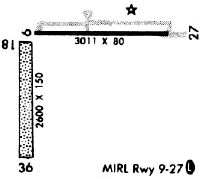
| Runways: | 09/27 18/36 |
| Longest Runway: | 09/27 is 3013 ft (918 m) long |
| Runways with an Instrument Approach: |
08A Airport Runway Details
| Runway 09/27 | 3013 ft x 80 ft (918 m x 24 m) | |
| Runway Length Source: | 3RD PARTY SURVEY as of 06/03/2017 | |
| Surface: | Asphalt - Fair condition - No special surface treatment | |
| Runway Edge Lights: | Medium Intensity | |
Runway Weight Bearing Capacity (in thousands of pounds) |
||
| Single Wheel Landing Gear: | 15.0 | |
Runway 09 |
Runway 27 |
|
Elevation: |
196.7 | 196.4 |
Latitude: |
32-31-45.7745N | 32-31-46.1888N |
Longitude: |
086-19-59.1763W | 086-19-23.9836W |
|
Runway True Alignment: |
089 | 269 |
Glide Path Angle: |
0.0 degrees | 0.0 degrees |
Traffic Pattern: |
Left | Left |
Runway Markings Type: |
Nonprecision Instrument | Nonprecision Instrument |
Runway Markings Condition: |
Fair | Fair |
Object at End: |
TREES | TREES |
Object Height: |
61 | 73 |
Distance from End: |
677 | 816 |
Object Centerline Offset: |
263 ft. right of centerline | 317 ft. right of centerline |
REIL: |
Yes | Yes |
| Runway 18/36 | 2876 ft x 130 ft (877 m x 40 m) | |
| Runway Length Source: | 3RD PARTY SURVEY as of 06/03/2017 | |
| Surface: | Asphalt - Fair condition - No special surface treatment | |
Runway 18 |
Runway 36 |
|
Elevation: |
195.7 | 191.0 |
Latitude: |
32-31-44.6694N | 32-31-16.2159N |
Longitude: |
086-20-01.9210W | 086-20-02.4719W |
|
Runway True Alignment: |
181 | 001 |
Glide Path Angle: |
0.0 degrees | 0.0 degrees |
Runway Markings Type: |
Basic | Basic |
Runway Markings Condition: |
Good | Good |
Object at End: |
TREES | TREES |
Object Height: |
69 | 76 |
Object Marked/Lighted?: |
Marked | |
Distance from End: |
918 | 344 |
Object Centerline Offset: |
263 ft. right of centerline | 317 ft. right of centerline |
Threshold Elevation: |
193.9 | |
Displaced Threshold: |
983 | |
Threshold Latitude: |
32-31-25.9431N | |
Threshold Longitude: |
086-20-02.2838W |
Services
Airframe Repair: |
Major |
Powerplant Repair: |
Major |
Bottled Oxygen: |
None |
Bulk Oxygen: |
None |
Fuel Available: |
100LL, Jet A |
Landing Fees: |
No |
Parking: |
Tiedowns available |
Maps & Diagrams
08A Sectional
Flight Planning
at skyvector.com
at skyvector.com