Location
Latitude: |
32-31-43.8000N (32.528833) |
Longitude: |
094-58-18.3000W (-94.97175) |
Elevation: |
296.5 feet MSL (90 m MSL) |
Magnetic Variation: |
1.6 E (as of April 2024 from WMM2020 model) |
Time Zone: |
UTC -6.0 (Standard Time) UTC -5.0 (Daylight Savings Time) |
From City: |
02 N.M. SW of Gladewater, Texas |
Found On: |
Memphis Chart |
FAA Region: |
ASW |
Contacts
Manager: |
Publicly owned: |
| CHARLIE SMITH PO BOX 1725 GLADEWATER, TX 75647 903-845-2586 |
CITY OF GLADEWATER PO BOX 1725 GLADEWATER, TX 75647 903-845-2196 |
Operations
Airport Status: |
Operational |
Facility Use: |
Public |
Type: |
Airport |
Activation Date: |
03/1951 |
Control tower: |
No |
Attendance (Months/Days/Hours): |
Months/Days/Hours ALL/ALL/0800-1700 |
Boundary ARTCC: |
ZFW (Fort Worth) |
Responsible ARTCC: |
ZFW (Fort Worth) |
Lighting Schedule: |
SS-SR |
Segmented Circle Indicator: |
No |
Traffic Pattern Altitude (MSL): |
1296 feet (395 m) |
NOTAMs Facility: |
FTW |
NOTAM-D Service: |
Yes |
International Airport of Entry: |
No |
Customs Landing Rights: |
No |
Military Landing Rights: |
Yes |
Civil/Military Joint Use: |
No |
Based Aircraft
| Single Engine: | 46 |
| Multi Engine: | 4 |
| GA Helicopters: | 3 |
Annual Operations (as of 03/29/2019)
| Total Operations: | 17600 | |
| Air Taxi: | 100 | 0.6% |
| GA Local: | 12900 | 73.3% |
| GA Itinerant: | 4600 | 26.1% |
Communications
| CTAF: | 122.900 |
| Approach: | LONGVIEW 124.275 124.275 FORT WORTH ARTCC |
| Departure: | LONGVIEW 124.275 124.275 FORT WORTH ARTCC |
- APCH/DEP CTL SVC PRVDD BY FORT WORTH ARTCC (ZFW) ON FREQS 126.325/346.25 (SHREVEPORT RCAG) WHEN LONGVIEW APCH CTL (GGG) CLSD.
Fixed Based Operators (FBOs) & Fuel
(Click on a business for detail)
Please help us keep this information up to date. This is a FREE SERVICE just like everything else on Airport Guide! If you see that a business needs to be added, modified, or deleted please fill out our Update Form.
To add, modify, or delete a business click here.
Please help us keep this information up to date. This is a FREE SERVICE just like everything else on Airport Guide! If you see that a business needs to be added, modified, or deleted please fill out our Update Form.
Area Code: 903 |
| Business Name | Frequency | Phone | Fuel Grade |
|---|---|---|---|
| Don Maxwell Aviation Services
Update FBO info |
Unicom 122.9 | 845-5844 | 100LL, MOGAS |
Flight Service Stations
| Primary | Alternate | |
| FSS on Field: | N | |
| FSS Name (ID): | Fort Worth(FTW) | |
| Frequency: | ||
| Toll Free Phone: | 1-800-WX-BRIEF |
Instrument Procedures / Charts
FAA Terminal Procedures valid from 0901Z 03/21/24 to 0901Z 04/18/24.
There are various types of charts available for an airport. They are listed in the Page Type column. Here is a legend for those types:
APD - Airport Diagram
DP - Departure Procedure Charts
HOT - Hot Spots
IAP - Instrument Approach Procedure Charts
MIN - Minimums
STAR - Standard Terminal Arrival Charts
| Page Type | Page Name | Volume | Action Since Last Cycle |
|---|---|---|---|
| IAP | RNAV (GPS) RWY 14 | SC-2 | |
| IAP | RNAV (GPS) RWY 32 | SC-2 | |
| MIN | TAKEOFF MINIMUMS | SC-2 |
Terminal Procedures are only available for airports in several countries with more being added all the time. If you are looking for a specific country's charts, please send an email to support(at)airportguide.com stating the country name. This will be used to prioritize the implementation.
Navigation Aids (Navaids) near 07F
| Dist (NM) | ID | Morse Code | Name | Type | Freq | True Hdg | Mag Hdg |
|---|---|---|---|---|---|---|---|
| 7.9 | ABG | . _ _ . . . _ _ . | Ambassador | NDB | 404 | 295 | 293 |
| 9.9 | GG | _ _ . _ _ . | Veels | NDB | 410 | 116 | 114 |
| 12.9 | GGG | _ _ . _ _ . _ _ . | Gregg County | VORTAC | 112.90 | 120 | 119 |
| 21.2 | HNO | . . . . _ . _ _ _ | Henderson | NDB | 371 | 164 | 162 |
| 24.2 | TYR | _ _ . _ _ . _ . | Tyler | VOR-DME | 114.20 | 244 | 242 |
| 26.1 | TY | _ _ . _ _ | Indoo | NDB | 320 | 255 | 253 |
| 29.0 | UIM | . . _ . . _ _ | Quitman | DME | 114 | 316 | 314 |
| 39.3 | FZT | . . _ . _ _ . . _ | Frankston | VOR-DME | 111.40 | 226 | 224 |
| 40.1 | RPF | . _ . . _ _ . . . _ . | Carthage | NDB | 332 | 121 | 120 |
| 41.4 | JSO | . _ _ _ . . . _ _ _ | Cherokee County | NDB | 263 | 197 | 195 |
| 48.8 | AHX | . _ . . . . _ . . _ | Athens | NDB | 269 | 243 | 241 |
| 49.4 | SLR | . . . . _ . . . _ . | Sulphur Springs | DME | 109 | 324 | 322 |
| 52.4 | ATA | . _ _ . _ | Atlanta | NDB | 347 | 48 | 47 |
| 52.5 | VIV | . . . _ . . . . . _ | Vivian | NDB | 284 | 67 | 66 |
| 54.5 | GXD | _ _ . _ . . _ _ . . | Nacogdoches | NDB | 391 | 165 | 164 |
| 57.3 | CSZ | _ . _ . . . . _ _ . . | Crossroads | NDB | 215 | 241 | 239 |
| 57.7 | SHV | . . . . . . . . . . _ | Shreveport | VOT | 108.20 | 94 | 93 |
| 58.2 | PSN | . _ _ . . . . _ . | Palestine | NDB | 375 | 219 | 217 |
| 58.9 | CZJ | _ . _ . _ _ . . . _ _ _ | Amason | NDB | 341 | 134 | 133 |
| 60.5 | EIC | . . . _ . _ . | Belcher | VORTAC | 117.40 | 75 | 74 |
Nearby Airports with Fuel
Notices to Airmen (NOTAMS)
Remarks
| A110-1 | FOR CD CTC FORT WORTH ARTCC AT 817-858-7584. |
| A17 | FOR SVC AFT HRS CALL 903-295-8860. |
| A33-17/35 | NMRS CRACKS, LOOSE STONES. |
| A58-14 | 30 FT TREES, 0-200 FT DSTC, 167 FT R. |
Runways
Runway Summary
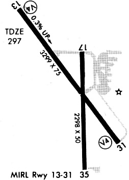
| Runways: | 14/32 17/35 |
| Longest Runway: | 14/32 is 3299 ft (1006 m) long |
| Runways with an Instrument Approach: |
07F Airport Runway Details
| Runway 14/32 | 3299 ft x 75 ft (1006 m x 23 m) | |
| Runway Length Source: | 3RD PARTY SURVEY as of 02/13/2011 | |
| Surface: | Asphalt - Poor condition - No special surface treatment | |
| Runway Edge Lights: | Medium Intensity | |
Runway Weight Bearing Capacity (in thousands of pounds) |
||
| Single Wheel Landing Gear: | 12.5 | |
Runway 14 |
Runway 32 |
|
Elevation: |
285.0 | 295.6 |
Latitude: |
32-31-59.5545N | 32-31-33.5934N |
Longitude: |
094-58-31.1672W | 094-58-07.8057W |
|
Runway True Alignment: |
143 | 323 |
Glide Path Angle: |
3.0 degrees | 0.0 degrees |
Traffic Pattern: |
Left | Left |
Runway Markings Type: |
Nonprecision Instrument | Nonprecision Instrument |
Runway Markings Condition: |
Good | Good |
Object at End: |
TREES | TREES |
Object Height: |
21 | 80 |
Distance from End: |
201 | 1026 |
Object Centerline Offset: |
137 ft. right of centerline | 180 ft. left of centerline |
Visual Glide Slope Indicators: |
2-Light PAPI On Left Side Of Runway | |
Threshold Crossing Height: |
44 |
| Runway 17/35 | 2300 ft x 50 ft (701 m x 15 m) | |
| Runway Length Source: | 3RD PARTY SURVEY as of 02/13/2011 | |
| Surface: | Asphalt - Poor condition - No special surface treatment | |
Runway Weight Bearing Capacity (in thousands of pounds) |
||
| Single Wheel Landing Gear: | 7.0 | |
Runway 17 |
Runway 35 |
|
Elevation: |
291.9 | 294.6 |
Latitude: |
32-31-51.2661N | 32-31-28.5179N |
Longitude: |
094-58-16.8314W | 094-58-16.2803W |
|
Runway True Alignment: |
179 | 359 |
Glide Path Angle: |
0.0 degrees | 0.0 degrees |
Traffic Pattern: |
Left | Left |
Runway Markings Type: |
Basic | Basic |
Runway Markings Condition: |
Good | Good |
Object at End: |
TREES | TREES |
Object Height: |
40 | 30 |
Distance from End: |
269 | 360 |
Object Centerline Offset: |
137 ft. right of centerline | 180 ft. left of centerline |
Services
Airframe Repair: |
Major |
Powerplant Repair: |
Major |
Fuel Available: |
100LL |
Maps & Diagrams
07F Sectional
Flight Planning
at skyvector.com
at skyvector.com