Location
Latitude: |
38-10-26.7060N (38.174085) |
Longitude: |
085-44-11.3770W (-85.736494) |
Elevation: |
500.8 feet MSL (153 m MSL) |
Magnetic Variation: |
5.1 W (as of April 2024 from WMM2020 model) |
Time Zone: |
UTC -5.0 (Standard Time) UTC -4.0 (Daylight Savings Time) |
From City: |
04 N.M. S of Louisville, Kentucky |
Found On: |
St Louis Chart |
FAA Region: |
ASO |
Contacts
Manager: |
Publicly owned: |
| DAN MANN 700 ADMINISTRATION DRIVE LOUISVILLE, KY 40209 502-380-8200 |
LOUISVILLE REGIONAL ARPT AUTH 700 ADMINISTRATION DRIVE LOUISVILLE, KY 40209 502-380-8200 |
Operations
Airport Status: |
Operational |
Facility Use: |
Public |
Type: |
Airport |
Activation Date: |
11/1942 |
Control tower: |
Yes |
Attendance (Months/Days/Hours): |
Months/Days/Hours ALL/ALL/ALL |
Boundary ARTCC: |
ZID (Indianapolis) |
Responsible ARTCC: |
ZID (Indianapolis) |
Segmented Circle Indicator: |
No |
Traffic Pattern Altitude (MSL): |
1501 feet (458 m) |
NOTAMs Facility: |
SDF |
NOTAM-D Service: |
Yes |
International Airport of Entry: |
No |
Customs Landing Rights: |
Yes |
Military Landing Rights: |
Yes |
Civil/Military Joint Use: |
No |
Aircraft Rescue and Firefighting: |
Class I ARFF Index: C Air Carrier Service: Scheduled Certification Date: 05/1973 |
Based Aircraft
| Single Engine: | 1 |
| Jet Engine: | 22 |
| Military Aircraft: | 8 |
Annual Operations (as of 07/31/2022)
| Total Operations: | 176003 | |
| Commercial: | 148086 | 84.1% |
| Air Taxi: | 15531 | 8.8% |
| GA Local: | 242 | 0.1% |
| GA Itinerant: | 10030 | 5.7% |
| Military Aircraft: | 2114 | 1.2% |
Communications
| Unicom: | 122.950 |
| Tower: | LOUISVILLE 124.2 257.8 Hrs: 24 |
| Clearance Del.: | 126.1 275.8 |
| Ground: | 121.7 348.6 |
| Approach: | LOUISVILLE 132.075 134.15 327.0 Hrs: 24 |
| Departure: | LOUISVILLE 132.075 134.15 327.0 Hrs: 24 |
| ATIS: | 118.725 Hrs: 24 |
| ASOS: | (502-367-1492) |
| REDSTONE STAR: | 132.075 |
| REDSTONE STAR: | 327.0 |
| EMERG: | 121.5 |
| EMERG: | 243.0 |
| ANG OPS: | 268.1 |
| CHERI STAR: | 132.075 |
| CLASS C: | 132.075 |
| CHERI STAR: | 327.0 |
| DARBY STAR: | 132.075 |
| DARBY STAR: | 327.0 |
Fixed Based Operators (FBOs) & Fuel
(Click on a business for detail)
Please help us keep this information up to date. This is a FREE SERVICE just like everything else on Airport Guide! If you see that a business needs to be added, modified, or deleted please fill out our Update Form.
To add, modify, or delete a business click here.
Please help us keep this information up to date. This is a FREE SERVICE just like everything else on Airport Guide! If you see that a business needs to be added, modified, or deleted please fill out our Update Form.
Area Code: 502 |
| Business Name | Frequency | Phone | Fuel Grade |
|---|---|---|---|
| Johnson Controls Av Center
Update FBO info |
Unicom 122.95 | 368-1515 | 100LL, Jet A |
Flight Service Stations
| Primary | Alternate | |
| FSS on Field: | N | |
| FSS Name (ID): | Louisville(LOU) | |
| Frequency: | ||
| Toll Free Phone: | 1-800-WX-BRIEF |
Instrument Procedures / Charts
FAA Terminal Procedures valid from 0901Z 03/21/24 to 0901Z 04/18/24.
There are various types of charts available for an airport. They are listed in the Page Type column. Here is a legend for those types:
APD - Airport Diagram
DP - Departure Procedure Charts
HOT - Hot Spots
IAP - Instrument Approach Procedure Charts
MIN - Minimums
STAR - Standard Terminal Arrival Charts
Terminal Procedures are only available for airports in several countries with more being added all the time. If you are looking for a specific country's charts, please send an email to support(at)airportguide.com stating the country name. This will be used to prioritize the implementation.
Navigation Aids (Navaids) near SDF
| Dist (NM) | ID | Morse Code | Name | Type | Freq | True Hdg | Mag Hdg |
|---|---|---|---|---|---|---|---|
| 0.8 | SDF | . . . _ . . . . _ . | Louisville Standifd | VOT | 111.00 | 356 | 361 |
| 4.8 | BQM | _ . . . _ _ . _ _ _ | Bowman | DME | 112.2 | 45 | 50 |
| 5.2 | LK | . _ . . _ . _ | Laang | NDB | 414 | 109 | 114 |
| 8.6 | IIU | . . . . . . _ | Louisville | VORTAC | 114.80 | 119 | 124 |
| 17.2 | GOI | _ _ . _ _ _ . . | Godman | NDB | 396 | 221 | 226 |
| 18.0 | JV | . _ _ _ . . . _ | Catch | NDB | 331 | 359 | 364 |
| 19.5 | FTK | . . _ . _ _ . _ | Fort Knox | VOR-DME | 109.60 | 214 | 219 |
| 22.9 | BRY | _ . . . . _ . _ . _ _ | Bardstown/Dcmsnd | NDB | 248 | 148 | 153 |
| 25.3 | ABB | . _ _ . . . _ . . . | Nabb | VORTAC | 112.40 | 10 | 15 |
| 29.3 | MYS | _ _ _ . _ _ . . . | Mystic | VOR | 108.20 | 235 | 240 |
| 32.7 | EWO | . . _ _ _ _ _ | New Hope | VOR-DME | 113.95 | 174 | 179 |
| 37.2 | GVR | _ _ . . . . _ . _ . | Hanover | DME | 114.65 | 19 | 24 |
| 39.1 | FFT | . . _ . . . _ . _ | Frankfort | VOR | 109.40 | 89 | 94 |
| 40.1 | IKY | . . _ . _ _ . _ _ | Springfield | NDB | 429 | 143 | 148 |
| 43.1 | EQZ | . _ _ . _ _ _ . . | Captain | NDB | 308 | 345 | 350 |
| 46.0 | TEL | _ . . _ . . | Tell City | NDB | 206 | 258 | 263 |
| 51.7 | BFR | _ . . . . . _ . . _ . | Bedford | NDB | 344 | 320 | 325 |
| 51.9 | TYC | _ _ . _ _ _ . _ . | Taylor County | NDB | 272 | 153 | 158 |
| 52.0 | LE | . _ . . . | Blayd | NDB | 242 | 102 | 107 |
| 57.7 | HNB | . . . . _ . _ . . . | Huntingburg | VOR-DME | 109.20 | 274 | 279 |
Nearby Airports with Fuel
Notices to Airmen (NOTAMS)
Remarks
| A110-1 | BIRDS ON & INVOF ARPT. |
| A110-12 | TAIL HGT 65 FT OR GTR 24 HR PPR. |
| A110-14 | ANG: FAA GP 6 ACFT 24 HR PPR. |
| A110-2 | CTN: CONST IN PROG; FQT RWY & TWY CLOSURES PSBL. |
| A110-3 | ANG/123TAC RECON. |
| A110-4 | ASDE-X IN USE; OPR PARROT WITH ALT RPRTG MODE & ADS-B IF EQUIPPED ENABLED ON ALL ARPT SFCS. |
| A110-5 | LINE UP & WAIT WAIVER IN EFCT SS-SR AT INTXN OF RWY 17R AT TWY B OR AT TWY A8 & INTXN OF RWY 35L AT TWY A OR AT TWY B. |
| A110-8 | ANG: DUTY HR 1200-2000Z/DT 1300-2100Z MON-THU; 1200-1800Z/DT 1300-1900Z FRI. APVL AUTH 123 AW/OGC; BASE OPS D741-4581/4584/ C502-413-4581/4584. ENG START & TAXI CLNC - DERBY OPS. |
| A30A-17L | TWY E INTXN DEP 7700 FT AVBL. |
| A30A-17R | STD DEP POINTS AT TWY B & TWY A8. REQS USE OF RWY 17R EXTN. TKOF AT TWY B ASDA/TORA/TODA 10245 FT. |
| A30A-35L | STD DEP POINTS AT TWY A & TWY B; REQS USE OF RWY 35L EXTN; TKOF AT TWY A & TWY B ASDA/TORA/TODA 10250 FT. |
| A30A-35R | TWY E2 INTXN DEP 6300 FT AVBL. |
| E111 | EXISTED PRIOR TO 1959. |
Runways
Runway Summary
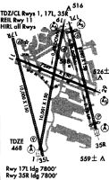
| Runways: | 11/29 17L/35R 17R/35L |
| Longest Runway: | 17R/35L is 11887 ft (3623 m) long |
| Runways with an Instrument Approach: | 29, 17L, 35R, 17R, 35L |
SDF Airport Runway Details
| Runway 11/29 | 7251 ft x 150 ft (2210 m x 46 m) | |
| Runway Length Source: | 3RD PARTY SURVEY as of 02/28/2013 | |
| Surface: | Concrete - Good condition - Wire comb or wire tine | |
| Runway Pavement Class: | 71 /R/B/W/T | |
| Runway Edge Lights: | High Intensity | |
Runway Weight Bearing Capacity (in thousands of pounds) |
||
| Single Wheel Landing Gear: | 75.0 | |
| Dual Wheel Landing Gear: | 170.0 | |
| Dual Tandem Wheel Landing Gear: | 360.0 | |
| Dual Dual Tandem Wheel Landing Gear: | 850.0 | |
Runway 11 |
Runway 29 |
|
Elevation: |
476.5 | 480.0 |
Latitude: |
38-10-48.8184N | 38-10-22.9958N |
Longitude: |
085-44-50.4619W | 085-43-25.7630W |
|
Runway True Alignment: |
111 | 291 |
ILS Type: |
LOCALIZER | |
Glide Path Angle: |
3.0 degrees | 3.0 degrees |
Traffic Pattern: |
Left | Left |
Runway Markings Type: |
Basic | Precision Instrument |
Runway Markings Condition: |
Good | Good |
Object at End: |
BLDG | |
Object Height: |
55 | |
Distance from End: |
1375 | |
Object Centerline Offset: |
325 ft. right of centerline | |
Visual Glide Slope Indicators: |
4-Light PAPI On Left Side Of Runway | 4-Light PAPI On Left Side Of Runway |
Runway Visual Range (RVR): |
Rollout | Touchdown |
Approach Light System: |
1,400 Foot Medium Intensity Approach Lighting System With Runway Alignment Indicator Lights | |
Threshold Crossing Height: |
65 | 56 |
Declared Distances |
||
Take Off Run Avbl. (TORA): |
7250 | 7250 |
Take Off Distance Avbl. (TODA): |
7250 | 7250 |
Actual Stop Dist. Avbl. (ASDA): |
6946 | 7250 |
Landing Dist. Avbl. (LDA): |
6946 | 7250 |
| Runway 17L/35R | 8578 ft x 150 ft (2615 m x 46 m) | |
| Runway Length Source: | 3RD PARTY SURVEY as of 02/28/2013 | |
| Surface: | Concrete - Good condition - Saw-cut or plastic grooved | |
| Runway Pavement Class: | 71 /R/B/W/T | |
| Runway Edge Lights: | High Intensity | |
Runway Weight Bearing Capacity (in thousands of pounds) |
||
| Single Wheel Landing Gear: | 75.0 | |
| Dual Wheel Landing Gear: | 207.0 | |
| Dual Tandem Wheel Landing Gear: | 360.0 | |
| Dual Dual Tandem Wheel Landing Gear: | 850.0 | |
Runway 17L |
Runway 35R |
|
Elevation: |
500.8 | 471.3 |
Latitude: |
38-11-14.2764N | 38-09-52.4016N |
Longitude: |
085-43-52.8304W | 085-43-24.8694W |
|
Runway True Alignment: |
165 | 345 |
ILS Type: |
ILS/DME | ILS/DME |
Glide Path Angle: |
3.3 degrees | 3.0 degrees |
Runway Markings Type: |
Precision Instrument | Precision Instrument |
Runway Markings Condition: |
Good | Good |
Object Centerline Offset: |
325 ft. right of centerline | |
Visual Glide Slope Indicators: |
4-Light PAPI On Left Side Of Runway | 4-Light PAPI On Right Side Of Runway |
Runway Visual Range (RVR): |
Touchdown, Midfield, Rollout | Touchdown, Midfield, Rollout |
Approach Light System: |
1,400 Foot Medium Intensity Approach Lighting System With Runway Alignment Indicator Lights | Standard 2,400 Foot High Intensity Approach Lighting System With Sequenced Flashers, Cat. II or III Config. |
Touchdown Lights: |
Yes | Yes |
Centerline Lights: |
Yes | Yes |
Threshold Crossing Height: |
71 | 72 |
Threshold Elevation: |
499.4 | 471.4 |
Displaced Threshold: |
328 | 449 |
Threshold Latitude: |
38-11-11.1449N | 38-09-56.6902N |
Threshold Longitude: |
085-43-51.7597W | 085-43-26.3316W |
Declared Distances |
||
Take Off Run Avbl. (TORA): |
8579 | 8579 |
Take Off Distance Avbl. (TODA): |
8579 | 8579 |
Actual Stop Dist. Avbl. (ASDA): |
8129 | 8250 |
Landing Dist. Avbl. (LDA): |
7800 | 7800 |
| Runway 17R/35L | 11887 ft x 150 ft (3623 m x 46 m) | |
| Runway Length Source: | 3RD PARTY SURVEY as of 02/28/2013 | |
| Surface: | Concrete - Good condition - Saw-cut or plastic grooved | |
| Runway Pavement Class: | 71 /R/B/W/T | |
| Runway Edge Lights: | High Intensity | |
Runway Weight Bearing Capacity (in thousands of pounds) |
||
| Single Wheel Landing Gear: | 75.0 | |
| Dual Wheel Landing Gear: | 207.0 | |
| Dual Tandem Wheel Landing Gear: | 360.0 | |
| Dual Dual Tandem Wheel Landing Gear: | 850.0 | |
Runway 17R |
Runway 35L |
|
Elevation: |
489.3 | 461.3 |
Latitude: |
38-11-13.1566N | 38-09-19.4495N |
Longitude: |
085-44-55.6065W | 085-44-18.0888W |
|
Runway True Alignment: |
165 | 345 |
ILS Type: |
ILS/DME | ILS/DME |
Glide Path Angle: |
3.0 degrees | 3.0 degrees |
Runway Markings Type: |
Precision Instrument | Precision Instrument |
Runway Markings Condition: |
Good | Good |
Object Centerline Offset: |
325 ft. right of centerline | |
Visual Glide Slope Indicators: |
4-Light PAPI On Right Side Of Runway | 4-Light PAPI On Left Side Of Runway |
Runway Visual Range (RVR): |
Touchdown, Midfield, Rollout | Touchdown, Midfield, Rollout |
Approach Light System: |
1,400 Foot Medium Intensity Approach Lighting System With Runway Alignment Indicator Lights | Standard 2,400 Foot High Intensity Approach Lighting System With Sequenced Flashers, Cat. II or III Config. |
Touchdown Lights: |
Yes | Yes |
Centerline Lights: |
Yes | Yes |
Threshold Crossing Height: |
64 | 75 |
Threshold Elevation: |
485.4 | 461.4 |
Displaced Threshold: |
846 | 1040 |
Threshold Latitude: |
38-11-05.0596N | 38-09-29.3989N |
Threshold Longitude: |
085-44-52.9341W | 085-44-21.3712W |
Declared Distances |
||
Take Off Run Avbl. (TORA): |
11095 | 11290 |
Take Off Distance Avbl. (TODA): |
11095 | 11290 |
Actual Stop Dist. Avbl. (ASDA): |
11095 | 11290 |
Landing Dist. Avbl. (LDA): |
10000 | 10000 |
Services
Airframe Repair: |
Major |
Powerplant Repair: |
Major |
Bulk Oxygen: |
None |
Fuel Available: |
100LL |
Landing Fees: |
No |
Parking: |
Hangars and tiedowns available |
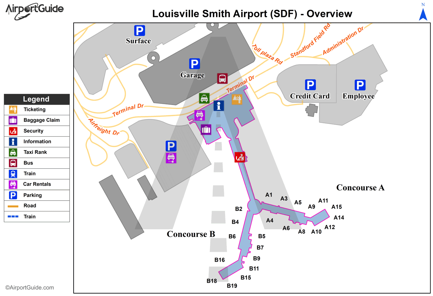
Maps & Diagrams
SDF Sectional
Flight Planning
at skyvector.com
at skyvector.com