
Location
Latitude: |
38-46-52.68N (38.7813) |
Longitude: |
009-08-09.312W (-9.13592) |
Elevation: |
374 feet MSL (114 m MSL) |
Magnetic Variation: |
1.3 W (as of April 2024 from WMM2020 model) |
Time Zone: |
UTC +0.0 (Standard Time) UTC +1.0 (Daylight Savings Time) |
Contacts
Manager: |
: |
Operations
Airport Status: |
Operational |
Facility Use: |
Public |
Type: |
Airport |
Traffic Pattern Altitude (MSL): |
1374 feet (419 m) |
Based Aircraft
Annual Operations (as of )
Communications
| RDO: | 127.9 |
| INFO: | 123.75 |
| TWR: | 118.1 |
| CLD: | 118.95 |
| GND: | 121.75 |
| APP: | 119.1 |
| ATIS: | 124.15 |
Fixed Based Operators (FBOs) & Fuel
(Click on a business for detail)
Please help us keep this information up to date. This is a FREE SERVICE just like everything else on Airport Guide! If you see that a business needs to be added, modified, or deleted please fill out our Update Form.
To add, modify, or delete a business click here.
Please help us keep this information up to date. This is a FREE SERVICE just like everything else on Airport Guide! If you see that a business needs to be added, modified, or deleted please fill out our Update Form.
| Business Name | Frequency | Phone | Fuel Grade |
|---|---|---|---|
| WEXJET AVIATION
Website Update FBO info |
(+351) 910 224 808 |
Flight Service Stations
| Primary | Alternate | |
| FSS on Field: | ||
| FSS Name (ID): | ||
| Frequency: | ||
| Toll Free Phone: |
Instrument Procedures / Charts
Terminal Procedures are only available for airports in several countries with more being added all the time. If you are looking for a specific country's charts, please send an email to support(at)airportguide.com stating the country name. This will be used to prioritize the implementation.
Navigation Aids (Navaids) near LIS
| Dist (NM) | ID | Morse Code | Name | Type | Freq | True Hdg | Mag Hdg |
|---|---|---|---|---|---|---|---|
| 4.7 | LO | Lisboa Lom | NDB | 401 | 22 | 23 | |
| 6.1 | MIO | Montijo | NDB | 322 | 134 | 135 | |
| 6.5 | MOJ | Montijo | TACAN | 110.00 | 132 | 133 | |
| 6.6 | LIS | Lisboa | VOR-DME | 114.80 | 349 | 350 | |
| 9.3 | CP | Caparica | NDB | 389 | 205 | 206 | |
| 10.0 | SRA | Sintra | VORTAC | 112.10 | 286 | 287 | |
| 10.8 | CAS | Cascais | VOR-DME | 114.30 | 259 | 260 | |
| 10.9 | CA | Cascais | NDB | 359 | 252 | 253 | |
| 13.5 | LAR | Arruda | NDB | 382 | 19 | 20 | |
| 21.5 | ESP | Espichel | VORTAC | 112.50 | 186 | 187 | |
| 60.9 | FTM | Fatima | VOR-DME | 113.50 | 29 | 30 | |
| 64.1 | MTR | Monte Real | TACAN | 109.60 | 10 | 11 | |
| 68.2 | BJA | Beja | NDB | 376 | 122 | 123 | |
| 68.6 | MTL | Monte Real | NDB | 336 | 9 | 10 | |
| 69.0 | BEJ | Beja | VORTAC | 115.80 | 124 | 125 | |
| 73.7 | NSA | Nisa | VORTAC | 115.50 | 50 | 51 | |
| 88.3 | CB | Coimbra | NDB | 426 | 20 | 21 |
Nearby Airports with Fuel
| Dist (NM) | Name (Airport IDs) | True Hdg | Mag Hdg | Fuel Grade |
|---|---|---|---|---|
| 10.8 | Cascais Airport (CAT LPCS) |
251 | 252 | 100LL |
Notices to Airmen (NOTAMS)
Remarks
No remarks for this landing facility
Runways
Runway Summary
| Runways: | 02/20 [X] 17/35 |
| Longest Runway: | 02/20 is 12162 ft (3707 m) long |
| Runways with an Instrument Approach: |
LIS Airport Runway Details
| Runway 02/20 | 12162 ft x 148 ft (3707 m x 45 m) | |
| Runway Edge Lights: | Yes Intensity | |
Runway 02 |
Runway 20 |
|
Elevation: |
331 | 347 |
Latitude: |
38.765678 | 38.796474 |
Longitude: |
-9.144302 | -9.127831 |
|
Runway True Alignment: |
22 | 202 |
Glide Path Angle: |
0.0 degrees | 0.0 degrees |
REIL: |
Yes | Yes |
Threshold Elevation: |
331 | 347 |
Displaced Threshold: |
296 | 1969 |
| Runway [X] 17/35 | 7874 ft x 148 ft (2400 m x 45 m) | |
| Runway Edge Lights: | Yes Intensity | |
Runway [X] 17 |
Runway [X] 35 |
|
Elevation: |
374 | 332 |
Latitude: |
38.78620147705 | 38.76499938964 |
Longitude: |
-9.137209892272 | -9.131600379943 |
|
Runway True Alignment: |
168 | 348 |
Glide Path Angle: |
0.0 degrees | 0.0 degrees |
REIL: |
Yes | Yes |
Threshold Elevation: |
374 | 332 |
Displaced Threshold: |
492 |
Services
Fuel Available: |
100LL |
Maps & Diagrams
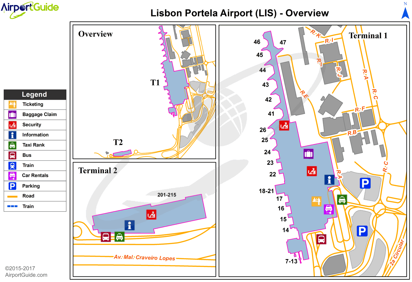
LIS Sectional
Flight Planning
at skyvector.com
at skyvector.com
