
Location
Latitude: |
52-09-56.5164N (52.165699) |
Longitude: |
020-58-01.5605E (20.9671) |
Elevation: |
362 feet MSL (110 m MSL) |
Magnetic Variation: |
6.9 E (as of April 2024 from WMM2020 model) |
Time Zone: |
UTC +1.0 (Standard Time) UTC +2.0 (Daylight Savings Time) |
Contacts
Manager: |
: |
Operations
Airport Status: |
Operational |
Facility Use: |
Public |
Type: |
Airport |
Traffic Pattern Altitude (MSL): |
1362 feet (415 m) |
Based Aircraft
Annual Operations (as of )
Communications
| TWR: | 118.3 |
| TWR: | 118.1 |
| TWR: | 119.4 |
| TWR: | 118.1 |
| TWR: | 118.6 |
| TWR: | 120 |
| TWR: | 120.8 |
| CLNC DEL: | 121.6 |
| GND: | 119 |
| PREM START: | 124 |
| TAXIING: | 121.7 |
| TRANSIT: | 131.5 |
| TYUMEN TAXIING: | 119 |
| TAXIING: | 121.8 |
| START: | 120.8 |
| GND: | 121.9 |
| TYUMEN START: | 118.2 |
| CHELYABINSK START: | 125.2 |
| TAXIING: | 121.7 |
| TYUMEN APP: | 126.1 |
| APP: | 125.9 |
| WARSZAWA APP: | 128.8 |
| PERM APP: | 127.1 |
| CHELYABINSK APP: | 124.7 |
| APP: | 134.3 |
| TYUMEN ATIS: | 121.7 |
| PERM ATIS: | 126.4 |
| ATIS: | 127.8 |
| ATIS: | 120.45 |
| ATIS: | 124.8 |
| ATIS: | 123.4 |
| TYUMEN KRUG: | 120.4 |
| WARSZAWA DIR: | 129.375 |
| METEO: | 126.6 |
| KRUG: | 120.4 |
| ASR: | 118.7 |
| CHELYABINSK METEO: | 128.3 |
| GCA: | 120 |
| ASR: | 120.8 |
| ASR: | 120.4 |
| KRUG: | 120.3 |
| METEO: | 126.4 |
Fixed Based Operators (FBOs) & Fuel
(Click on a business for detail)
Please help us keep this information up to date. This is a FREE SERVICE just like everything else on Airport Guide! If you see that a business needs to be added, modified, or deleted please fill out our Update Form.
To add, modify, or delete a business click here.
Please help us keep this information up to date. This is a FREE SERVICE just like everything else on Airport Guide! If you see that a business needs to be added, modified, or deleted please fill out our Update Form.
| Business Name | Frequency | Phone | Fuel Grade |
|---|
Flight Service Stations
| Primary | Alternate | |
| FSS on Field: | ||
| FSS Name (ID): | ||
| Frequency: | ||
| Toll Free Phone: |
Instrument Procedures / Charts
Terminal Procedures are only available for airports in several countries with more being added all the time. If you are looking for a specific country's charts, please send an email to support(at)airportguide.com stating the country name. This will be used to prioritize the implementation.
Navigation Aids (Navaids) near WAW
| Dist (NM) | ID | Morse Code | Name | Type | Freq | True Hdg | Mag Hdg |
|---|---|---|---|---|---|---|---|
| 0.4 | OKE | Okecie | VOR-DME | 113.40 | 313 | 306 | |
| 1.4 | AY | Warszawa | NDB | 375 | 294 | 287 | |
| 1.6 | W | Warszawa | NDB | 361 | 151 | 144 | |
| 4.6 | WAO | Warszawa | NDB | 412 | 151 | 144 | |
| 6.5 | WAG | Warszawa | NDB | 336 | 294 | 287 | |
| 7.6 | PNO | Piaseczno | NDB | 330 | 152 | 145 | |
| 12.7 | WAR | Zaborowek | VOR-DME | 114.90 | 296 | 289 | |
| 15.7 | LIN | Linin | VOR-DME | 113.10 | 153 | 146 | |
| 23.3 | KRN | Karnice | VOR-DME | 117.80 | 235 | 228 | |
| 45.4 | SIE | Siedlce | VOR-DME | 114.70 | 90 | 83 | |
| 53.2 | LDZ | Lodz | VOR-DME | 112.40 | 246 | 239 | |
| 73.9 | TZ | Lask | NDB | 322 | 240 | 233 | |
| 74.9 | T | Lask | NDB | 664 | 240 | 233 | |
| 76.3 | DW | Szczytno | NDB | 288 | 358 | 351 | |
| 95.0 | JED | Jedow | VOR-DME | 115.60 | 196 | 189 | |
| 97.3 | MRA | Mragowo | VOR-DME | 117.30 | 3 | 356 |
Nearby Airports with Fuel
| Dist (NM) | Name (Airport IDs) | True Hdg | Mag Hdg | Fuel Grade |
|---|
Notices to Airmen (NOTAMS)
Remarks
No remarks for this landing facility
Runways
Runway Summary
| Runways: | 11/29 15/33 |
| Longest Runway: | 15/33 is 12106 ft (3690 m) long |
| Runways with an Instrument Approach: |
WAW Airport Runway Details
| Runway 11/29 | 9186 ft x 164 ft (2800 m x 50 m) | |
| Runway Edge Lights: | Yes Intensity | |
Runway 11 |
Runway 29 |
|
Elevation: |
361 | 344 |
Latitude: |
52.17150115966 | 52.16099929809 |
Longitude: |
20.946699142456 | 20.983900070190 |
|
Runway True Alignment: |
114.8 | 294.8 |
Glide Path Angle: |
0.0 degrees | 0.0 degrees |
REIL: |
Yes | Yes |
Threshold Elevation: |
361 | 344 |
Displaced Threshold: |
1640 |
| Runway 15/33 | 12106 ft x 196 ft (3690 m x 60 m) | |
| Runway Edge Lights: | Yes Intensity | |
Runway 15 |
Runway 33 |
|
Elevation: |
351 | 351 |
Latitude: |
52.17860031127 | 52.14939880371 |
Longitude: |
20.955900192260 | 20.981399536132 |
|
Runway True Alignment: |
152 | 332 |
Glide Path Angle: |
0.0 degrees | 0.0 degrees |
REIL: |
Yes | Yes |
Threshold Elevation: |
351 | 351 |
Services
Maps & Diagrams
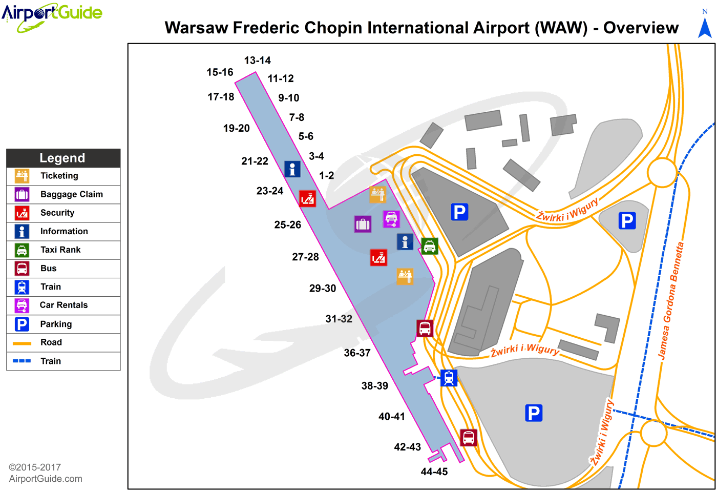
WAW Sectional
Flight Planning
at skyvector.com
at skyvector.com
