
Location
Latitude: |
31-38-09.9628N (31.636101) |
Longitude: |
106-25-44.4031W (-106.429001) |
Elevation: |
3904 feet MSL (1190 m MSL) |
Magnetic Variation: |
7.5 E (as of April 2024 from WMM2020 model) |
Time Zone: |
UTC -7.0 (Standard Time) UTC -6.0 (Daylight Savings Time) |
Contacts
Manager: |
: |
Operations
Airport Status: |
Operational |
Facility Use: |
Public |
Type: |
Airport |
Traffic Pattern Altitude (MSL): |
4904 feet (1495 m) |
Based Aircraft
Annual Operations (as of )
Communications
| JUAREZ TWR: | 118.9 |
| JUAREZ APP: | 119.9 |
Fixed Based Operators (FBOs) & Fuel
(Click on a business for detail)
Please help us keep this information up to date. This is a FREE SERVICE just like everything else on Airport Guide! If you see that a business needs to be added, modified, or deleted please fill out our Update Form.
To add, modify, or delete a business click here.
Please help us keep this information up to date. This is a FREE SERVICE just like everything else on Airport Guide! If you see that a business needs to be added, modified, or deleted please fill out our Update Form.
| Business Name | Frequency | Phone | Fuel Grade |
|---|
Flight Service Stations
| Primary | Alternate | |
| FSS on Field: | ||
| FSS Name (ID): | ||
| Frequency: | ||
| Toll Free Phone: |
Instrument Procedures / Charts
Terminal Procedures are only available for airports in several countries with more being added all the time. If you are looking for a specific country's charts, please send an email to support(at)airportguide.com stating the country name. This will be used to prioritize the implementation.
Navigation Aids (Navaids) near CJS
| Dist (NM) | ID | Morse Code | Name | Type | Freq | True Hdg | Mag Hdg |
|---|---|---|---|---|---|---|---|
| 0.1 | CJS | Juarez | VOR-DME | 116.70 | 86 | 79 | |
| 0.1 | CJS | _ . _ . . _ _ _ . . . | Ciudad Juarez | VOR-DME | 116.70 | 90 | 83 |
| 10.6 | ELP | . . _ . . . _ _ . | El Paso | VOT | 111.00 | 17 | 10 |
| 13.1 | ELP | . . _ . . . _ _ . | El Paso | VORTAC | 115.20 | 34 | 27 |
| 14.6 | EL | . . _ . . | Valtr | NDB | 242 | 22 | 15 |
| 20.6 | EWM | . . _ _ _ _ | Newman | VORTAC | 112.40 | 22 | 15 |
| 53.9 | HUP | . . . . . . _ . _ _ . | Hudspeth | VORTAC | 115.00 | 94 | 87 |
| 59.5 | CUS | _ . _ . . . _ . . . | Columbus | VOR-DME | 111.20 | 280 | 272 |
| 68.9 | SFL | . . . . . _ . . _ . . | Salt Flat | VORTAC | 113.00 | 84 | 77 |
| 71.1 | DMN | _ . . _ _ _ . | Deming | VORTAC | 108.60 | 302 | 294 |
| 74.2 | BWS | _ . . . . _ _ . . . | Boles | DME | 113.65 | 16 | 9 |
| 75.3 | HMN | . . . . _ _ _ . | Holloman | TACAN | 114.50 | 12 | 5 |
| 78.3 | PIO | . _ _ . . . _ _ _ | Pinon | VOR-DME | 110.40 | 46 | 39 |
| 90.9 | VHN | . . . _ . . . . _ . | Van Horn | NDB | 233 | 111 | 104 |
Nearby Airports with Fuel
| Dist (NM) | Name (Airport IDs) | True Hdg | Mag Hdg | Fuel Grade |
|---|---|---|---|---|
| 10.6 | El Paso International Airport (ELP KELP ELP) |
14 | 7 | 100LL, Jet A-1+ |
| 16.1 | Fabens Airport (E35) |
116 | 109 | 100LL |
| 20.3 | Dona Ana County International Jetport Airport (DNA) |
316 | 308 | 100LL, Jet A-1+ |
| 46.5 | Las Cruces International Airport (LRU KLRU LRU) |
327 | 319 | 100LL, Jet A-1+ |
| 75.5 | Alamogordo-White Sands Regional Airport (ALM KALM ALM) |
16 | 9 | 100LL, Jet A-1+ |
| 75.7 | Deming Municipal Airport (DMN KDMN DMN) |
300 | 292 | 100LL, Jet A-1+ |
| 91.2 | Culberson County Airport (VHN KVHN VHN) |
111 | 104 | 100LL, Jet A-1+ |
Notices to Airmen (NOTAMS)
Remarks
No remarks for this landing facility
Runways
Services
Bottled Oxygen: |
None |
Bulk Oxygen: |
None |
Fuel Available: |
100LL, Jet A-1+ |
Landing Fees: |
No |
Parking: |
Tiedowns available |
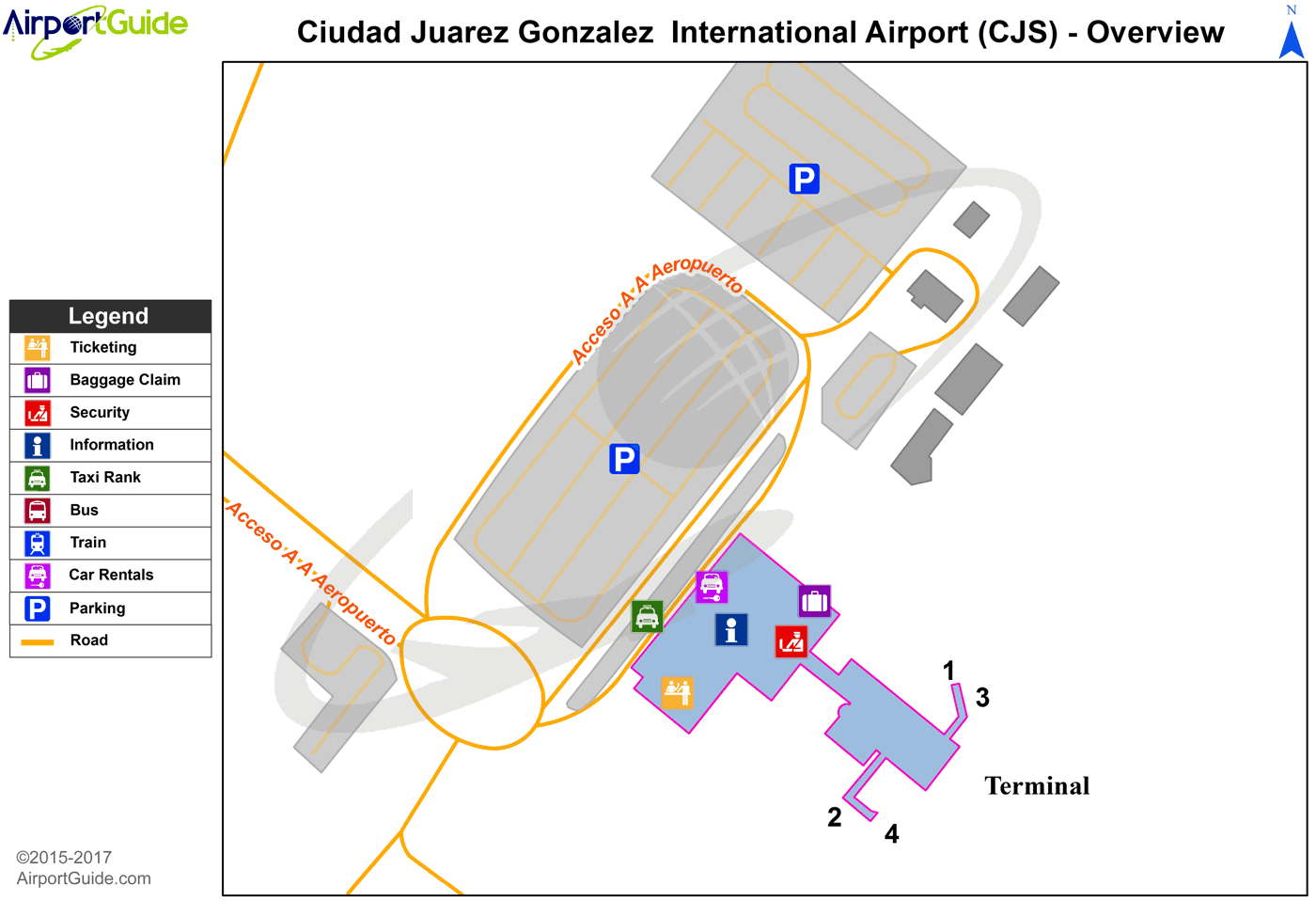
Maps & Diagrams
CJS Sectional
Flight Planning
at skyvector.com
at skyvector.com
