
Location
Latitude: |
44-32-07.44N (44.5354) |
Longitude: |
011-17-19.32E (11.2887) |
Elevation: |
123 feet MSL (37 m MSL) |
Magnetic Variation: |
3.9 E (as of April 2024 from WMM2020 model) |
Time Zone: |
UTC +1.0 (Standard Time) UTC +2.0 (Daylight Savings Time) |
Contacts
Manager: |
: |
Operations
Airport Status: |
Operational |
Facility Use: |
Public |
Type: |
Airport |
Traffic Pattern Altitude (MSL): |
1123 feet (342 m) |
Based Aircraft
Annual Operations (as of )
Communications
| TWR: | 120.8 |
| Tower Discretional: | 120.1 |
| GND: | 121.925 |
| Approach East: | 118.15 |
| Approach West: | 133.775 |
| Approach West Discretional: | 120.1 |
| ATIS: | 134.875 |
Fixed Based Operators (FBOs) & Fuel
(Click on a business for detail)
Please help us keep this information up to date. This is a FREE SERVICE just like everything else on Airport Guide! If you see that a business needs to be added, modified, or deleted please fill out our Update Form.
To add, modify, or delete a business click here.
Please help us keep this information up to date. This is a FREE SERVICE just like everything else on Airport Guide! If you see that a business needs to be added, modified, or deleted please fill out our Update Form.
| Business Name | Frequency | Phone | Fuel Grade |
|---|
Flight Service Stations
| Primary | Alternate | |
| FSS on Field: | ||
| FSS Name (ID): | ||
| Frequency: | ||
| Toll Free Phone: |
Instrument Procedures / Charts
Terminal Procedures are only available for airports in several countries with more being added all the time. If you are looking for a specific country's charts, please send an email to support(at)airportguide.com stating the country name. This will be used to prioritize the implementation.
Navigation Aids (Navaids) near BLQ
| Dist (NM) | ID | Morse Code | Name | Type | Freq | True Hdg | Mag Hdg |
|---|---|---|---|---|---|---|---|
| 0.1 | BOA | Bologna | VOR-DME | 117.10 | 41 | 37 | |
| 4.2 | BOA | Bologna | NDB | 413 | 296 | 292 | |
| 21.8 | FER | Ferrara | NDB | 427 | 39 | 35 | |
| 32.3 | FOR | Forli | NDB | 423 | 122 | 118 | |
| 32.9 | FRZ | Firenze | VORTAC | 115.20 | 202 | 198 | |
| 41.5 | CEV | Cervia | NDB | 387 | 112 | 108 | |
| 43.7 | PRT | Peretola | VOR-DME | 112.50 | 184 | 180 | |
| 45.8 | PAR | Parma | NDB | 306 | 292 | 288 | |
| 49.5 | GAZ | Gazoldo | NDB | 382 | 324 | 320 | |
| 49.9 | CEV | Cervia | TACAN | 113.60 | 112 | 108 | |
| 51.9 | VIL | Villafranca | NDB | 355 | 335 | 331 | |
| 53.1 | CHI | Chioggia | VOR-DME | 114.10 | 52 | 48 | |
| 53.1 | CHI | Chioggia | NDB | 408 | 52 | 48 | |
| 54.3 | PDV | Padova | NDB | 285 | 24 | 20 | |
| 54.8 | VIL | Villafranca | VORTAC | 115.80 | 342 | 338 | |
| 59.0 | RIM | Rimini | NDB | 335 | 117 | 113 | |
| 61.3 | PIN | Pisa | TACAN | 108.30 | 217 | 213 | |
| 64.2 | SAZ | Sarzana | TACAN | 111.10 | 245 | 241 | |
| 64.4 | PIS | Pisa | VOR-DME | 112.10 | 217 | 213 | |
| 65.0 | RIM | Rimini | VORTAC | 116.20 | 118 | 114 |
Nearby Airports with Fuel
| Dist (NM) | Name (Airport IDs) | True Hdg | Mag Hdg | Fuel Grade |
|---|
Notices to Airmen (NOTAMS)
Remarks
No remarks for this landing facility
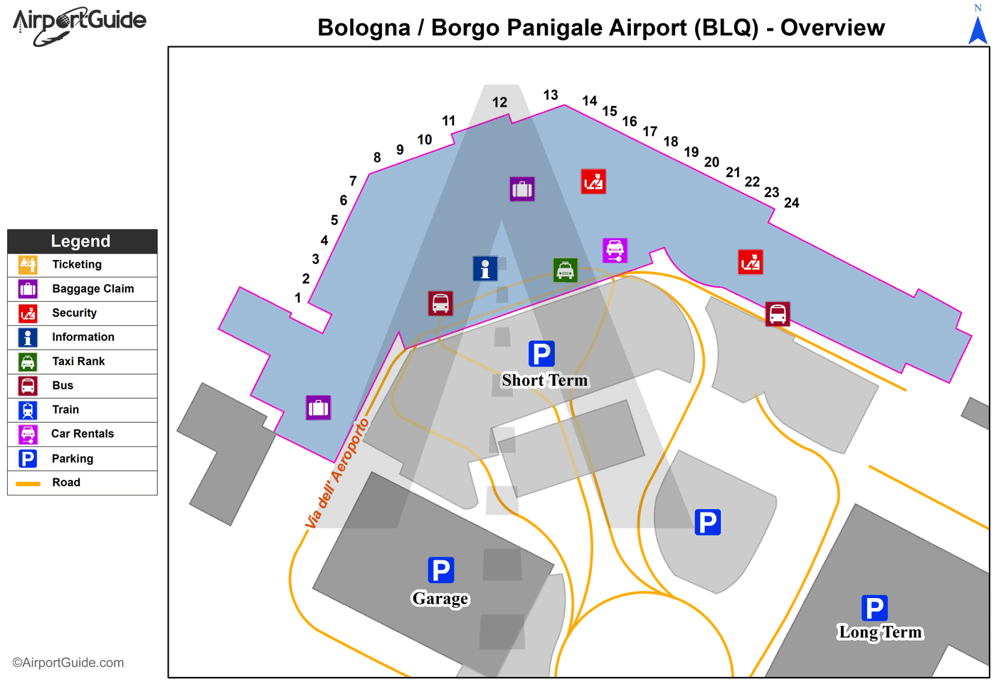
Runways
Runway Summary
| Runways: | 12/30 |
| Longest Runway: | 12/30 is 9196 ft (2803 m) long |
| Runways with an Instrument Approach: |
BLQ Airport Runway Details
| Runway 12/30 | 9196 ft x 148 ft (2803 m x 45 m) | |
| Runway Edge Lights: | Yes Intensity | |
Runway 12 |
Runway 30 |
|
Elevation: |
120 | 120 |
Latitude: |
44.54109954833 | 44.52980041503 |
Longitude: |
11.272899627685 | 11.304400444030 |
|
Runway True Alignment: |
117 | 297 |
Glide Path Angle: |
0.0 degrees | 0.0 degrees |
REIL: |
Yes | Yes |
Threshold Elevation: |
120 | 120 |
Displaced Threshold: |
1007 | 1188 |
Services
Maps & Diagrams
BLQ Sectional
Flight Planning
at skyvector.com
at skyvector.com
