
Location
Latitude: |
50-06-02.88N (50.1008) |
Longitude: |
014-15-36E (14.26) |
Elevation: |
1247 feet MSL (380 m MSL) |
Magnetic Variation: |
4.9 E (as of April 2024 from WMM2020 model) |
Time Zone: |
UTC +1.0 (Standard Time) UTC +2.0 (Daylight Savings Time) |
Contacts
Manager: |
: |
Operations
Airport Status: |
Operational |
Facility Use: |
Public |
Type: |
Airport |
Traffic Pattern Altitude (MSL): |
2247 feet (685 m) |
Based Aircraft
Annual Operations (as of )
Communications
| Ruzyně Information: | 118.31 |
| Ruzyně Tower: | 134.56 |
| Ruzyně Delivery: | 120.06 |
| Ruzyně Ground: | 121.91 |
| Praha Approach: | 120.53 |
| Praha Approach: | 127.58 |
| Ruzyně Radar: | 119.01 |
| ATIS: | 122.16 |
Fixed Based Operators (FBOs) & Fuel
(Click on a business for detail)
Please help us keep this information up to date. This is a FREE SERVICE just like everything else on Airport Guide! If you see that a business needs to be added, modified, or deleted please fill out our Update Form.
To add, modify, or delete a business click here.
Please help us keep this information up to date. This is a FREE SERVICE just like everything else on Airport Guide! If you see that a business needs to be added, modified, or deleted please fill out our Update Form.
| Business Name | Frequency | Phone | Fuel Grade |
|---|
Flight Service Stations
| Primary | Alternate | |
| FSS on Field: | ||
| FSS Name (ID): | ||
| Frequency: | ||
| Toll Free Phone: |
Instrument Procedures / Charts
Terminal Procedures are only available for airports in several countries with more being added all the time. If you are looking for a specific country's charts, please send an email to support(at)airportguide.com stating the country name. This will be used to prioritize the implementation.
Navigation Aids (Navaids) near PRG
| Dist (NM) | ID | Morse Code | Name | Type | Freq | True Hdg | Mag Hdg |
|---|---|---|---|---|---|---|---|
| 0.3 | OKL | Praha | VOR-DME | 112.60 | 157 | 152 | |
| 1.5 | L | Liboc | NDB | 372 | 41 | 36 | |
| 1.6 | D | Dejvice | NDB | 429 | 126 | 121 | |
| 4.9 | PR | Ruzyne North | NDB | 356 | 57 | 52 | |
| 5.3 | PG | Ruzyne Middle | NDB | 307 | 127 | 122 | |
| 9.3 | VO | Brezany | NDB | 333 | 44 | 39 | |
| 14.8 | KD | Kbely | NDB | 300 | 77 | 72 | |
| 20.2 | PSK | Pisek | DME | 117.60 | 205 | 200 | |
| 21.1 | NER | Neratovice | VOR-DME | 108.60 | 40 | 35 | |
| 21.9 | RAK | Rakovnik | NDB | 386 | 269 | 264 | |
| 39.2 | VLM | Vlasim | VOR-DME | 114.30 | 127 | 122 | |
| 41.6 | VOZ | Vozice | VOR-DME | 116.30 | 144 | 139 | |
| 45.0 | D | Line | NDB | 398 | 236 | 231 | |
| 46.7 | CF | Caslav | NDB | 346 | 104 | 99 | |
| 49.8 | HDO | Hermsdorf | VOR-DME | 115.00 | 4 | 359 | |
| 51.6 | KVY | Karlovy Vary | VOR-DME | 111.55 | 277 | 272 | |
| 56.4 | OKX | Frydlant | VOR-DME | 114.85 | 31 | 26 | |
| 60.1 | PK | Pardubice | NDB | 432 | 94 | 89 | |
| 60.4 | DRN | Dresden | VOR-DME | 114.35 | 335 | 330 | |
| 64.6 | DND | Dresden | DME | 115.40 | 342 | 337 |
Nearby Airports with Fuel
| Dist (NM) | Name (Airport IDs) | True Hdg | Mag Hdg | Fuel Grade |
|---|
Notices to Airmen (NOTAMS)
Remarks
No remarks for this landing facility
Runways
Runway Summary
| Runways: | [X] 04/22 06/24 12/30 |
| Longest Runway: | 06/24 is 12189 ft (3715 m) long |
| Runways with an Instrument Approach: |
PRG Airport Runway Details
| Runway [X] 04/22 | 6955 ft x 197 ft (2120 m x 60 m) | |
| Runway Edge Lights: | Yes Intensity | |
Runway [X] 04 |
Runway [X] 22 |
|
Elevation: |
1247 | 1174 |
Latitude: |
50.08769989013 | 50.10290145874 |
Longitude: |
14.266699790954 | 14.284399986267 |
|
Runway True Alignment: |
37 | 217 |
Glide Path Angle: |
0.0 degrees | 0.0 degrees |
REIL: |
Yes | Yes |
Threshold Elevation: |
1247 | 1174 |
| Runway 06/24 | 12189 ft x 148 ft (3715 m x 45 m) | |
| Runway Edge Lights: | Yes Intensity | |
Runway 06 |
Runway 24 |
|
Elevation: |
1202 | 1158 |
Latitude: |
50.10179901123 | 50.11600112915 |
Longitude: |
14.226300239562 | 14.273400306701 |
|
Runway True Alignment: |
65 | 245 |
Glide Path Angle: |
0.0 degrees | 0.0 degrees |
REIL: |
Yes | Yes |
Threshold Elevation: |
1202 | 1158 |
| Runway 12/30 | 10663 ft x 148 ft (3250 m x 45 m) | |
| Runway Edge Lights: | Yes Intensity | |
Runway 12 |
Runway 30 |
|
Elevation: |
1160 | 1232 |
Latitude: |
50.10800170898 | 50.09049987792 |
Longitude: |
14.245400428771 | 14.281700134277 |
|
Runway True Alignment: |
127 | 307 |
Glide Path Angle: |
0.0 degrees | 0.0 degrees |
REIL: |
Yes | Yes |
Threshold Elevation: |
1160 | 1232 |
Services
Maps & Diagrams
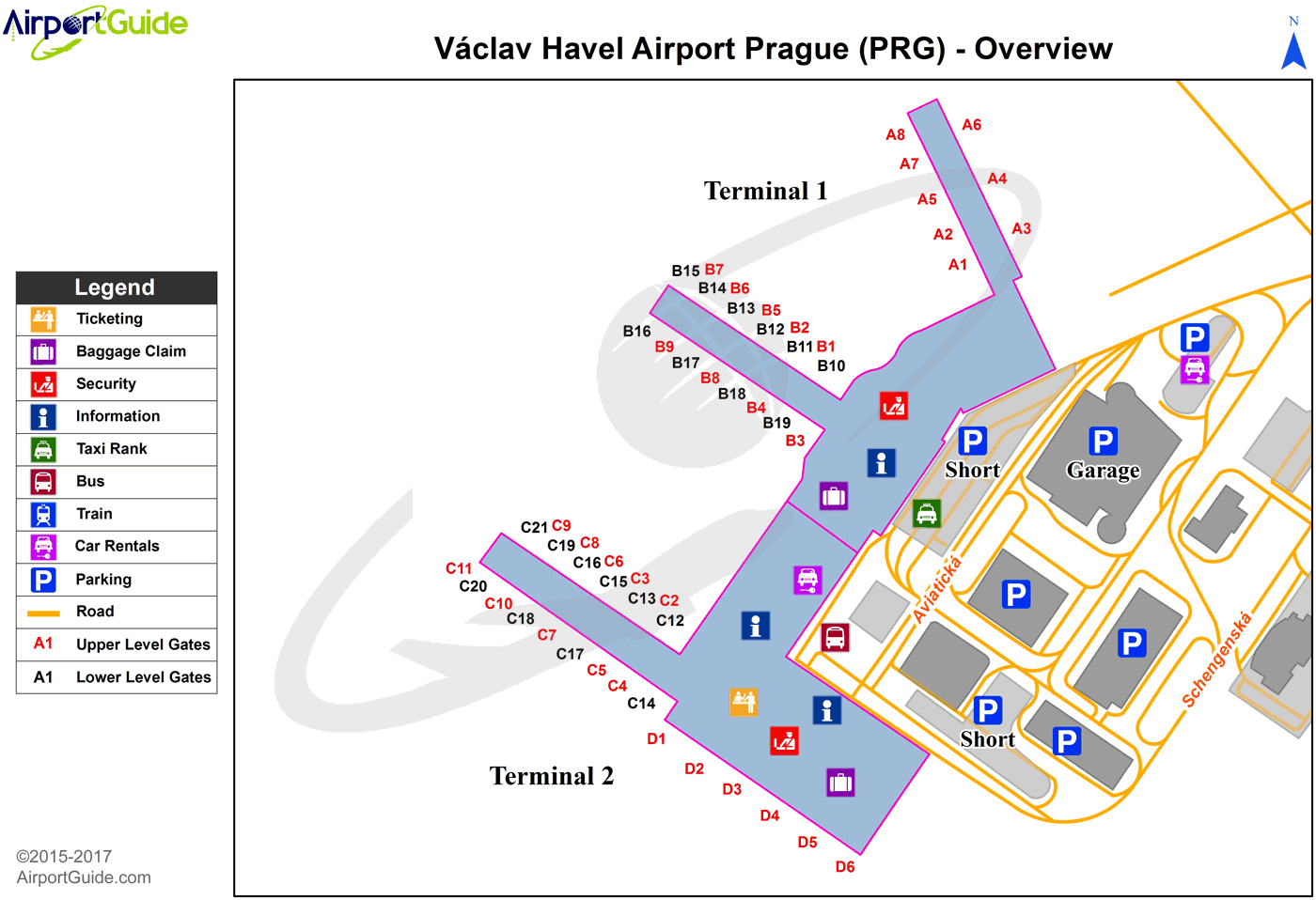
PRG Sectional
Flight Planning
at skyvector.com
at skyvector.com
